
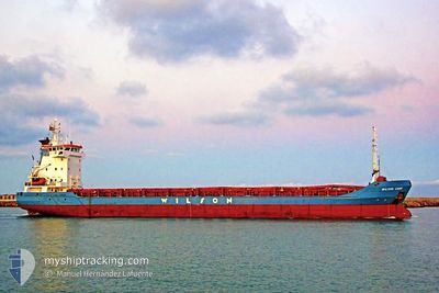
WILSON CORK
General Cargo
Current Trip
| Trip Time | 11 days |
|---|---|
| Trip Distance | 2307.96 nm |
| AVG Speed | 8 Noeuds |
| MAX Speed | 13.3 Noeuds |
| Tirant d eau | 5.4 m |
| AVG Wind | 9 knots |
| MAX Wind | 25 knots |
| MIN Temp | -3.3°C / 26.06°F |
| MAX Temp | 16.1°C / 60.98°F |
| Position reçue | 3 m depuis |
Current Position
| Longitude | --- |
|---|---|
| Latitude | --- |
| Etat | Moored |
| Vitesse | |
| Parcours | 102° |
| Zone | Kattegat |
| Station | T-AIS |
| Position reçue | 3 m depuis |
Info
Information
The current position of WILSON CORK is in Kattegat with coordinates 55.85528° / 9.87307° as reported on 2025-02-16 19:25 by AIS to our vessel tracker app. The vessel's current speed is 0 Noeuds and is currently inside the port of HORSENS.
The vessel WILSON CORK (IMO: 9178460, MMSI: 314180000) is a General Cargo that was built in 1998 ( 27 Age ). It's sailing under the flag of [BB] Barbados.
In this page you can find informations about the vessels current position, last detected port calls, and current voyage information. If the vessels is not in coverage by AIS you will find the latest position.
The current position of WILSON CORK is detected by our AIS receivers and we are not responsible for the reliability of the data. The last position was recorded while the vessel was in Coverage by the Ais receivers of our vessel tracking app.
The current draught of WILSON CORK as reported by AIS is 5.4 meters
Weather
| Temperature | -4°C / 24.8°F |
|---|---|
| Wind Speed | 1 knots |
| Direction | 69° ENE |
| Pressure | 1028.6 hPa |
| Humidity | 48.8 % |
| Cloud Coverage | --- |
Featured Company
Last Port Calls
| Port | Arrival | Departure | Time In Port |
|---|---|---|---|
| 2025-02-15 12:16 | |||
| 2025-02-02 12:48 | 2025-02-04 07:45 | 1 d | |
| 2025-01-31 09:21 | 2025-01-31 20:21 | 10 h | |
| 2025-01-26 06:05 | 2025-01-27 10:57 | 1 d | |
| 2025-01-23 10:33 | 2025-01-24 18:04 | 1 d | |
| 2025-01-16 06:15 | 2025-01-17 12:59 | 1 d | |
| 2025-01-15 08:26 | 2025-01-15 09:03 | 37 m | |
| 2025-01-15 07:20 | 2025-01-15 08:06 | 45 m | |
| 2025-01-09 22:19 | 2025-01-15 06:41 | 5 d | |
| 2025-01-09 21:10 | 2025-01-09 21:31 | 20 m |
Most Visited Ports (Last year)
| Port | Arrivals | |
|---|---|---|
| 5 | ||
| 3 | ||
| 3 | ||
| 2 | ||
| 2 | ||
| 2 |
Last Trips
| Origin | Departure | Destination | Arrival | Distance | |
|---|---|---|---|---|---|
| 2025-02-04 08:45 | 2025-02-15 13:16 | 2307.96 nm | |||
| 2025-01-31 21:21 | 2025-02-02 13:48 | 437.37 nm | |||
| 2025-01-27 11:57 | 2025-01-31 10:21 | 893.18 nm | |||
| 2025-01-24 18:04 | 2025-01-26 07:05 | 334.12 nm | |||
| 2025-01-17 12:59 | 2025-01-23 10:33 | 1151.79 nm | |||
| 2025-01-15 09:03 | 2025-01-16 06:15 | 230.03 nm | |||
| 2025-01-15 08:06 | 2025-01-15 08:26 | 1.91 nm | |||
| 2025-01-15 06:41 | 2025-01-15 07:20 | 4.55 nm | |||
| 2025-01-09 21:31 | 2025-01-09 22:19 | 4.16 nm | |||
| 2025-01-09 20:51 | 2025-01-09 21:10 | 1.53 nm |
Events
| Heure | Evenement | Détails | Position/ Destination | Info |
|---|---|---|---|---|
| 2025-02-15 12:56 | Etat Changé | Moored Under way using engine |
55.85528 / 9.87309
[DK] HORSENS
|
Vitesse: Parcours: 101° |
| 2025-02-15 12:29 | Arret |
55.85706 / 9.86604
[DK] HORSENS
|
Vitesse: 0.3 kn Parcours: 292° |
|
| 2025-02-15 12:16 | Port d'arrivée |
|
55.85484 / 9.88259
[DK] HORSENS
|
Vitesse: 5.2 kn Parcours: 281.2° |
| 2025-02-14 19:08 | Changement de destination | DKHOR DKHOR VIA KIEL CANAL |
54.90680 / 10.90655
DKHOR
|
Vitesse: 5.1 kn Parcours: 11.8° |
| 2025-02-14 17:19 | Detecté en mer | Danish part of the Kattegat |
54.74616 / 10.88432
Kattegat
DKHOR VIA KIEL CANAL
|
Vitesse: 4.4 kn Parcours: 0.7° |
| 2025-02-14 13:58 | Detecté en mer | Danish part of the Baltic Sea |
54.56129 / 10.59463
Baltic Sea
DKHOR VIA KIEL CANAL
|
Vitesse: 5.3 kn Parcours: 67.5° |
| 2025-02-14 12:31 | Tirant d'eau modifié | 5.4 5.5 |
54.51475 / 10.40557
DKHOR VIA KIEL CANAL
|
Vitesse: 4.3 kn Parcours: 70° |
| 2025-02-14 12:31 | Changement d'ETA | 2025/02/15 11:00 2025/02/14 19:00 |
54.51475 / 10.40557
DKHOR VIA KIEL CANAL
|
Vitesse: 4.3 kn Parcours: 70° |
| 2025-02-14 11:47 | Changement de zone | German part of the Baltic Sea German part of the North Sea |
54.46692 / 10.26105
Baltic Sea
DKHOR VIA KIEL CANAL
|
Vitesse: 10.3 kn Parcours: 27.3° |
| 2025-02-14 11:00 | Démarrage | 1.33 nm, South West of STICKENHΟRN SPORT |
54.36485 / 10.14611
DKHOR VIA KIEL CANAL
|
Vitesse: 3.6 kn Parcours: 100° |