
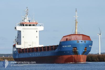
WILSON CADIZ
General Cargo
Current Trip
| Time Travelled | 3 days |
|---|---|
| Remaining Time | --- |
| Distance Travelled | 870.44 nm |
| Remaining Distance | --- |
| AVG Speed | 10.4 Noeuds |
| MAX Speed | 11.8 Noeuds |
| AVG Wind | 10.9 knots |
| MAX Wind | 22.9 knots |
| MIN Temp | 3.5°C / 38.3°F |
| MAX Temp | 13.7°C / 56.66°F |
| Tirant d eau | 5.8 m |
| Position reçue | 3 d depuis |
Current Position
| Longitude | -5.65854° |
|---|---|
| Latitude | 54.84744° |
| Etat | Under way using engine |
| Vitesse | 11.3 Noeuds |
| Parcours | 355.4° |
| Zone | Inner Seas off the West Coast of Scotland |
| Station | T-AIS |
| Position reçue | 3 d depuis |
Info
Information
The current position of WILSON CADIZ is in Inner Seas off the West Coast of Scotland with coordinates 54.84744° / -5.65854° as reported on 2024-05-01 21:00 by AIS to our vessel tracker app. The vessel's current speed is 11.3 Noeuds
The vessel WILSON CADIZ (IMO: 9192612, MMSI: 314216000) is a General Cargo that was built in 2000 ( 24 Age ). It's sailing under the flag of [BB] Barbados.
In this page you can find informations about the vessels current position, last detected port calls, and current voyage information. If the vessels is not in coverage by AIS you will find the latest position.
The current position of WILSON CADIZ is detected by our AIS receivers and we are not responsible for the reliability of the data. The last position was recorded while the vessel was in Coverage by the Ais receivers of our vessel tracking app.
The current draught of WILSON CADIZ as reported by AIS is 5.8 meters
Weather
| Temperature | 4.2°C / 39.56°F |
|---|---|
| Wind Speed | 3 knots |
| Direction | 197° SSW |
| Pressure | 1004.8 hPa |
| Humidity | 96.5 % |
| Cloud Coverage | 100 % |
Featured Company
Last Port Calls
| Port | Arrival | Departure | Time In Port |
|---|---|---|---|
| 2024-04-30 17:38 | 2024-05-01 19:26 | 1 d | |
| 2024-04-28 08:05 | 2024-04-29 21:12 | 1 d | |
| 2024-04-24 19:59 | 2024-04-24 20:59 | 1 h | |
| 2024-04-21 08:56 | 2024-04-23 00:09 | 1 d | |
| 2024-04-15 20:45 | 2024-04-21 07:50 | 5 d | |
| 2024-03-27 16:50 | 2024-04-15 07:12 | 18 d | |
| 2024-03-24 09:41 | 2024-03-26 15:04 | 2 d | |
| 2024-03-21 19:11 | 2024-03-21 23:44 | 4 h | |
| 2024-03-14 03:25 | 2024-03-19 17:51 | 5 d | |
| 2024-03-10 01:15 | 2024-03-14 00:45 | 3 d |
Most Visited Ports (Last year)
| Port | Arrivals | |
|---|---|---|
| 5 | ||
| 3 | ||
| 3 | ||
| 3 | ||
| 3 | ||
| 3 |
Last Trips
| Origin | Departure | Destination | Arrival | Distance | |
|---|---|---|---|---|---|
| 2024-04-29 22:12 | 2024-04-30 18:38 | 226.43 nm | |||
| 2024-04-24 22:59 | 2024-04-28 09:05 | 810.02 nm | |||
| 2024-04-23 02:09 | 2024-04-24 21:59 | 409.48 nm | |||
| 2024-04-21 09:50 | 2024-04-21 10:56 | 11.21 nm | |||
| 2024-04-15 09:12 | 2024-04-15 22:45 | 129.57 nm | |||
| 2024-03-26 16:04 | 2024-03-27 17:50 | 301.88 nm | |||
| 2024-03-22 00:44 | 2024-03-24 10:41 | 516.60 nm | |||
| 2024-03-19 18:51 | 2024-03-21 20:11 | 553.01 nm | |||
| 2024-03-14 01:45 | 2024-03-14 04:25 | 28.69 nm | |||
| 2024-03-06 18:47 | 2024-03-10 02:15 | 787.83 nm |
Events
| Heure | Evenement | Détails | Position/ Destination | Info |
|---|---|---|---|---|
| 2024-05-01 21:01 | Etat Changé | Default Under way using engine |
54.85299 / -5.65923
HUSAVIK
|
Vitesse: 11.3 kn Parcours: 355.4° |
| 2024-05-01 21:00 | Etat Changé | Under way using engine Default |
54.84744 / -5.65854
HUSAVIK
|
Vitesse: 11.2 kn Parcours: 356° |
| 2024-05-01 21:00 | Hors de la zone couverte |
54.84744 / -5.65854
Inner Seas off the West Coast of Scotland
HUSAVIK
|
Vitesse: 11.3 kn Parcours: 355.4° |
|
| 2024-05-01 20:42 | Etat Changé | Default Under way using engine |
54.79353 / -5.65046
HUSAVIK
|
Vitesse: 11 kn Parcours: 355.9° |
| 2024-05-01 19:32 | Tirant d'eau modifié | 5.8 4.2 |
54.65577 / -5.85093
HUSAVIK
|
Vitesse: 9.3 kn Parcours: 37.8° |
| 2024-05-01 19:32 | Changement de destination | HUSAVIK BELFAST |
54.65577 / -5.85093
HUSAVIK
|
Vitesse: 9.3 kn Parcours: 37.8° |
| 2024-05-01 19:32 | Changement d'ETA | 2024/05/05 09:00 2025/04/30 18:00 |
54.65577 / -5.85093
HUSAVIK
|
Vitesse: 9.3 kn Parcours: 37.8° |
| 2024-05-01 19:26 | PORT DE DEPART |
|
54.64558 / -5.86380
BELFAST
|
Vitesse: 9.1 kn Parcours: 35° |
| 2024-05-01 19:18 | Etat Changé | Under way using engine Default |
54.62882 / -5.88566
[GB] BELFAST
|
Vitesse: 6.3 kn Parcours: 55° |
| 2024-05-01 19:10 | Etat Changé | Default Under way using engine |
54.62123 / -5.90339
[GB] BELFAST
|
Vitesse: 0.1 kn Parcours: 38° |