

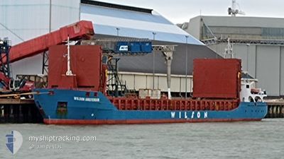
WILSON AMSTERDAM
General Cargo

Current Trip
| Time Travelled | 17 h, 51 mins |
|---|---|
| Remaining Time | 13 days |
| Distance Travelled | 134.55 nm |
| Remaining Distance | 1690.51 nm |
| AVG Speed | 8.8 Noeuds |
| MAX Speed | 11.8 Noeuds |
| AVG Wind | 13.2 knots |
| MAX Wind | 19.5 knots |
| MIN Temp | -0.8°C / 30.56°F |
| MAX Temp | 7.7°C / 45.86°F |
| Tirant d eau | 5.4 m |
| Position reçue | 1 m depuis |
Current Position
| Longitude | --- |
|---|---|
| Latitude | --- |
| Etat | Under way using engine |
| Vitesse | 5.1 Noeuds |
| Parcours | 232.7° |
| Zone | English Channel |
| Station | T-AIS |
| Position reçue | 1 m depuis |
Information
The current position of WILSON AMSTERDAM is in English Channel with coordinates 50.94559° / 1.21713° as reported on 2025-02-19 16:15 by AIS to our vessel tracker app. The vessel's current speed is 5.1 Noeuds and is heading at the port of SAGUNTO. The estimated time of arrival as calculated by MyShipTracking vessel tracking app is 2025-03-04 20:33 LT
The vessel WILSON AMSTERDAM (IMO: 9313735, MMSI: 314602000) is a General Cargo that was built in 2009 ( 16 Age ). It's sailing under the flag of [BB] Barbados.
In this page you can find informations about the vessels current position, last detected port calls, and current voyage information. If the vessels is not in coverage by AIS you will find the latest position.
The current position of WILSON AMSTERDAM is detected by our AIS receivers and we are not responsible for the reliability of the data. The last position was recorded while the vessel was in Coverage by the Ais receivers of our vessel tracking app.
The current draught of WILSON AMSTERDAM as reported by AIS is 5.4 meters
Weather
| Temperature | 7.7°C / 45.86°F |
|---|---|
| Wind Speed | 11 knots |
| Direction | 169° S |
| Pressure | 1016.8 hPa |
| Humidity | 79.8 % |
| Cloud Coverage | 100 % |


Featured Company
Last Port Calls
| Port | Arrival | Departure | Time In Port |
|---|---|---|---|
| 2025-02-16 12:31 | 2025-02-18 22:26 | 2 d | |
| 2025-02-11 09:53 | 2025-02-12 16:58 | 1 d | |
| 2025-02-05 02:20 | 2025-02-05 19:41 | 17 h | |
| 2025-02-02 23:41 | 2025-02-03 15:41 | 15 h | |
| 2025-01-30 17:57 | 2025-01-31 15:56 | 21 h | |
| 2025-01-23 07:25 | 2025-01-26 07:30 | 3 d | |
| 2025-01-03 19:17 | 2025-01-07 11:45 | 3 d | |
| 2024-12-21 18:19 | 2024-12-29 07:11 | 7 d | |
| 2024-12-18 08:59 | 2024-12-20 15:25 | 2 d | |
| 2024-12-07 02:00 | 2024-12-09 22:38 | 2 d |
Most Visited Ports (Last year)
| Port | Arrivals | |
|---|---|---|
| 4 | ||
| 2 | ||
| 2 | ||
| 2 | ||
| 2 | ||
| 2 |
Last Trips
| Origin | Departure | Destination | Arrival | Distance | |
|---|---|---|---|---|---|
| 2025-02-12 17:58 | 2025-02-16 13:31 | 681.35 nm | |||
| 2025-02-05 20:41 | 2025-02-11 10:53 | 981.98 nm | |||
| 2025-02-03 16:41 | 2025-02-05 03:20 | 342.12 nm | |||
| 2025-01-31 16:56 | 2025-02-03 00:41 | 109.78 nm | |||
| 2025-01-26 08:30 | 2025-01-30 18:57 | 481.70 nm | |||
| 2025-01-07 11:45 | 2025-01-23 08:25 | 1731.03 nm | |||
| 2024-12-29 07:11 | 2025-01-03 19:17 | 1033.41 nm | |||
| 2024-12-20 15:25 | 2024-12-21 18:19 | 172.19 nm | |||
| 2024-12-09 23:38 | 2024-12-18 08:59 | 1513.84 nm | |||
| 2024-11-29 15:30 | 2024-12-07 03:00 | 789.56 nm |
Events
| Heure | Evenement | Détails | Position/ Destination | Info |
|---|---|---|---|---|
| 2025-02-19 15:20 | Etat Changé | Under way using engine Default |
50.99830 / 1.32051
ES_SAG
|
Vitesse: 5.3 kn Parcours: 232° |
| 2025-02-19 15:17 | Etat Changé | Default Under way using engine |
51.00090 / 1.32567
ES_SAG
|
Vitesse: 5.2 kn Parcours: 231.5° |
| 2025-02-19 15:12 | Etat Changé | Under way using engine Default |
51.00594 / 1.33575
ES_SAG
|
Vitesse: 5.2 kn Parcours: 232° |
| 2025-02-19 15:10 | Etat Changé | Default Under way using engine |
51.00777 / 1.33935
ES_SAG
|
Vitesse: 5.2 kn Parcours: 230.9° |
| 2025-02-19 14:55 | Etat Changé | Under way using engine Default |
51.02132 / 1.36560
ES_SAG
|
Vitesse: 5.2 kn Parcours: 232° |
| 2025-02-19 14:53 | Etat Changé | Default Under way using engine |
51.02288 / 1.36859
ES_SAG
|
Vitesse: 5.2 kn Parcours: 230.2° |
| 2025-02-19 13:59 | Changement de zone | United Kingdom part of the English Channel United Kingdom part of the North Sea |
51.07596 / 1.46645
English Channel
ES_SAG
|
Vitesse: 5.2 kn Parcours: 234.7° |
| 2025-02-19 13:21 | Etat Changé | Under way using engine Default |
51.10940 / 1.53930
ES_SAG
|
Vitesse: 5.9 kn Parcours: 233° |
| 2025-02-19 13:09 | Etat Changé | Default Under way using engine |
51.12123 / 1.56545
ES_SAG
|
Vitesse: 6.7 kn Parcours: 233.2° |
| 2025-02-19 09:34 | Detecté en mer | United Kingdom part of the North Sea |
51.39878 / 2.06525
North Sea
ES_SAG
|
Vitesse: 8.6 kn Parcours: 293.2° |