
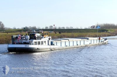
ONUS
Cargo
Current Trip
| Time Travelled | 10 days |
|---|---|
| Remaining Time | 22 h, 2 mins |
| Distance Travelled | 121.94 nm |
| Remaining Distance | 94.41 nm |
| AVG Speed | 5 Noeuds |
| MAX Speed | 7.6 Noeuds |
| AVG Wind | 9.4 knots |
| MAX Wind | 19.9 knots |
| MIN Temp | 4.2°C / 39.56°F |
| MAX Temp | 16.4°C / 61.52°F |
| Tirant d eau | 0.2 m |
| Position reçue | 49 m depuis |
Current Position
| Longitude | 5.68685° |
|---|---|
| Latitude | 50.79599° |
| Etat | Under way using engine |
| Vitesse | 6.4 Noeuds |
| Parcours | 335.2° |
| Zone | North Sea |
| Station | T-AIS |
| Position reçue | 49 m depuis |
Info
Information
The current position of ONUS is in North Sea with coordinates 50.79599° / 5.68685° as reported on 2024-04-28 08:47 by AIS to our vessel tracker app. The vessel's current speed is 6.4 Noeuds and is heading at the port of WIJK BIJ DUURSTEDE. The estimated time of arrival as calculated by MyShipTracking vessel tracking app is 2024-04-29 07:38 LT
The vessel ONUS (MMSI: 244870379) is a Cargo It's sailing under the flag of [NL] Netherlands.
In this page you can find informations about the vessels current position, last detected port calls, and current voyage information. If the vessels is not in coverage by AIS you will find the latest position.
The current position of ONUS is detected by our AIS receivers and we are not responsible for the reliability of the data. The last position was recorded while the vessel was in Coverage by the Ais receivers of our vessel tracking app.
The current draught of ONUS as reported by AIS is 0.2 meters
Weather
| Temperature | 13.5°C / 56.3°F |
|---|---|
| Wind Speed | 18 knots |
| Direction | 192° SSW |
| Pressure | 1007.1 hPa |
| Humidity | 70.7 % |
| Cloud Coverage | 100 % |
Featured Company
Last Port Calls
| Port | Arrival | Departure | Time In Port |
|---|---|---|---|
| 2024-04-17 19:54 | 2024-04-17 21:36 | 1 h | |
| 2024-04-17 12:37 | 2024-04-17 15:59 | 3 h | |
| 2024-04-16 16:42 | 2024-04-17 10:39 | 17 h | |
| 2024-04-16 12:02 | |||
| 2024-04-12 12:25 | 2024-04-12 14:08 | 1 h | |
| 2024-04-12 00:52 | 2024-04-12 11:06 | 10 h | |
| 2024-04-11 22:31 | 2024-04-11 22:42 | 10 m | |
| 2024-04-11 11:57 | 2024-04-11 12:18 | 21 m | |
| 2024-04-10 11:38 | 2024-04-11 07:30 | 19 h | |
| 2024-04-10 02:10 | 2024-04-10 11:14 | 9 h |
Last Trips
| Origin | Departure | Destination | Arrival | Distance | |
|---|---|---|---|---|---|
| 2024-04-17 17:59 | 2024-04-17 21:54 | 28.53 nm | |||
| 2024-04-17 12:39 | 2024-04-17 14:37 | 8.85 nm | |||
| 2024-04-16 14:02 | 2024-04-16 18:42 | 23.79 nm | |||
| 2024-04-12 13:06 | 2024-04-12 14:25 | 8.27 nm | |||
| 2024-04-12 00:42 | 2024-04-12 02:52 | 11.16 nm | |||
| 2024-04-11 14:18 | 2024-04-12 00:31 | 70.26 nm | |||
| 2024-04-11 09:30 | 2024-04-11 13:57 | 24.04 nm | |||
| 2024-04-10 13:14 | 2024-04-10 13:38 | 2.90 nm | |||
| 2024-04-10 01:43 | 2024-04-10 04:10 | 22.38 nm | |||
| 2024-04-09 20:19 | 2024-04-10 00:51 | 35.86 nm |
Events
| Heure | Evenement | Détails | Position/ Destination | Info |
|---|---|---|---|---|
| 2024-04-28 08:41 | Démarrage | 0.54 nm, South West of WAOLENWIERT |
50.79165 / 5.69084
BORN
|
Vitesse: 5.3 kn Parcours: 174.4° |
| 2024-04-28 08:40 | Etat Changé | Under way using engine Moored |
50.79331 / 5.69085
BORN
|
Vitesse: Parcours: 180° |
| 2024-04-28 08:33 | Etat Changé | Moored Under way using engine |
50.79352 / 5.69082
BORN
|
Vitesse: 2 kn Parcours: 192° |
| 2024-04-28 08:33 | Arret | 0.48 nm, South West of WAOLENWIERT |
50.79352 / 5.69082
BORN
|
Vitesse: Parcours: 180° |
| 2024-04-28 07:41 | Dans la zone couverte |
50.79657 / 5.69139
North Sea
|
Vitesse: 2 kn Parcours: 185.6° |
|
| 2024-04-28 05:41 | Hors de la zone couverte |
50.79728 / 5.69151
North Sea
|
Vitesse: Parcours: 124.6° |
|
| 2024-04-28 04:28 | Dans la zone couverte |
50.79728 / 5.69152
North Sea
|
Vitesse: Parcours: 124.6° |
|
| 2024-04-27 19:48 | Hors de la zone couverte |
50.79727 / 5.69153
North Sea
|
Vitesse: Parcours: 124.6° |
|
| 2024-04-27 19:48 | Arret | 0.4 nm, West of WAOLENWIERT |
50.79727 / 5.69153
BORN
|
Vitesse: Parcours: 183° |
| 2024-04-27 16:17 | Démarrage | 1.72 nm, South of BARGE TERMINAL BORN |
51.03350 / 5.79767
BORN
|
Vitesse: 3.2 kn Parcours: 199° |