

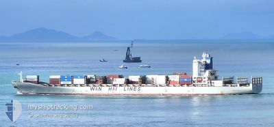
WAN HAI 501
Container Ship

Current Trip
SA JED
| Time Travelled | 2 days |
|---|---|
| Remaining Time | --- |
| Distance Travelled | 1108.09 nm |
| Remaining Distance | --- |
| AVG Speed | 17.4 Noeuds |
| MAX Speed | 19 Noeuds |
| AVG Wind | 10.6 knots |
| MAX Wind | 21 knots |
| MIN Temp | 25.2°C / 77.36°F |
| MAX Temp | 29.2°C / 84.56°F |
| Tirant d eau | 10.8 m |
| Position reçue | 1 d depuis |
Current Position
| Longitude | --- |
|---|---|
| Latitude | --- |
| Etat | Under way using engine |
| Vitesse | 18 Noeuds |
| Parcours | 138.4° |
| Zone | Red Sea |
| Station | T-AIS |
| Position reçue | 1 d depuis |
Information
The current position of WAN HAI 501 is in Red Sea with coordinates 16.91003° / 40.56301° as reported on 2025-03-25 17:04 by AIS to our vessel tracker app. The vessel's current speed is 18 Noeuds
The vessel WAN HAI 501 (IMO: 9294848, MMSI: 563382000) is a Container Ship that was built in 2005 ( 20 Age ). It's sailing under the flag of [SG] Singapore.
In this page you can find informations about the vessels current position, last detected port calls, and current voyage information. If the vessels is not in coverage by AIS you will find the latest position.
The current position of WAN HAI 501 is detected by our AIS receivers and we are not responsible for the reliability of the data. The last position was recorded while the vessel was in Coverage by the Ais receivers of our vessel tracking app.
The current draught of WAN HAI 501 as reported by AIS is 10.8 meters
Weather
| Temperature | 26.6°C / 79.88°F |
|---|---|
| Wind Speed | 12 knots |
| Direction | 97° E |
| Pressure | 1011.5 hPa |
| Humidity | 61.9 % |
| Cloud Coverage | 16 % |


Featured Company
Last Port Calls
| Port | Arrival | Departure | Time In Port |
|---|---|---|---|
| 2025-03-24 10:18 | 2025-03-25 01:53 | 15 h | |
| 2025-03-20 22:46 | 2025-03-22 16:47 | 1 d | |
| 2025-03-16 11:23 | 2025-03-17 01:15 | 13 h | |
| 2025-03-08 19:23 | 2025-03-09 22:04 | 1 d | |
| 2025-03-05 07:07 | 2025-03-06 01:15 | 18 h | |
| 2025-03-02 23:47 | 2025-03-03 12:50 | 13 h | |
| 2025-02-27 21:20 | 2025-02-28 13:49 | 16 h | |
| 2025-02-23 20:08 | 2025-02-25 18:30 | 1 d | |
| 2025-02-16 04:36 | 2025-02-16 16:28 | 11 h | |
| 2025-02-12 18:58 | 2025-02-14 17:03 | 1 d |
Most Visited Ports (Last year)
| Port | Arrivals | |
|---|---|---|
| 11 | ||
| 7 | ||
| 7 | ||
| 6 | ||
| 5 | ||
| 5 |
Last Trips
| Origin | Departure | Destination | Arrival | Distance | |
|---|---|---|---|---|---|
| 2025-03-22 16:47 | 2025-03-24 10:18 | 628.01 nm | |||
| 2025-03-17 01:15 | 2025-03-20 22:46 | 630.51 nm | |||
| 2025-03-09 22:04 | 2025-03-16 11:23 | 2334.95 nm | |||
| 2025-03-06 01:15 | 2025-03-08 19:23 | 1200.92 nm | |||
| 2025-03-03 12:50 | 2025-03-05 07:07 | 443.31 nm | |||
| 2025-02-28 13:49 | 2025-03-02 23:47 | 266.90 nm | |||
| 2025-02-25 18:30 | 2025-02-27 21:20 | 790.28 nm | |||
| 2025-02-16 16:28 | 2025-02-23 20:08 | 2343.82 nm | |||
| 2025-02-14 17:03 | 2025-02-16 04:36 | 625.67 nm | |||
| 2025-02-10 03:17 | 2025-02-12 18:58 | 622.81 nm |
Events
| Heure | Evenement | Détails | Position/ Destination | Info |
|---|---|---|---|---|
| 2025-03-25 17:08 | Etat Changé | Default Under way using engine |
16.89427 / 40.57764
SA JED
|
Vitesse: 18 kn Parcours: 138.4° |
| 2025-03-25 17:04 | Hors de la zone couverte |
16.91003 / 40.56301
Red Sea
|
Vitesse: 18 kn Parcours: 138.4° |
|
| 2025-03-25 17:00 | Etat Changé | Under way using engine Default |
16.92351 / 40.55060
SA JED
|
Vitesse: 18.1 kn Parcours: 139° |
| 2025-03-25 16:41 | Etat Changé | Default Under way using engine |
16.99828 / 40.48451
SA JED
|
Vitesse: 17.8 kn Parcours: 137.8° |
| 2025-03-25 16:05 | Etat Changé | Under way using engine Default |
17.13144 / 40.36450
SA JED
|
Vitesse: 18.1 kn Parcours: 139° |
| 2025-03-25 15:37 | Etat Changé | Default Under way using engine |
17.23762 / 40.26673
SA JED
|
Vitesse: 17.9 kn Parcours: 138.3° |
| 2025-03-25 14:51 | Changement de zone | Eritrean part of the Red Sea Saudi Arabian part of the Red Sea |
17.41190 / 40.10641
Red Sea
|
Vitesse: 18 kn Parcours: 138.6° |
| 2025-03-25 14:51 | Etat Changé | Under way using engine Default |
17.41190 / 40.10641
SA JED
|
Vitesse: 17.9 kn Parcours: 138° |
| 2025-03-25 14:26 | Etat Changé | Default Under way using engine |
17.50424 / 40.02155
SA JED
|
Vitesse: 18 kn Parcours: 138.9° |
| 2025-03-25 14:15 | Etat Changé | Under way using engine Default |
17.54652 / 39.98287
SA JED
|
Vitesse: 18 kn Parcours: 139° |