
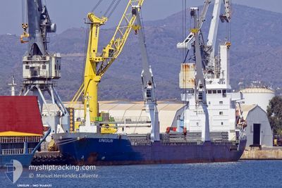
UNISUN
General Cargo
Current Trip
| Time Travelled | 10 days |
|---|---|
| Remaining Time | --- |
| Distance Travelled | 3090.71 nm |
| Remaining Distance | --- |
| AVG Speed | 12.6 Noeuds |
| MAX Speed | 14.5 Noeuds |
| AVG Wind | 17.4 knots |
| MAX Wind | 28.8 knots |
| MIN Temp | 15°C / 59°F |
| MAX Temp | 20.3°C / 68.54°F |
| Tirant d eau | 6.2 m |
| Position reçue | 7 h, 1 m depuis |
Current Position
| Longitude | -17.02670° |
|---|---|
| Latitude | 20.73004° |
| Etat | Under way using engine |
| Vitesse | 12.9 Noeuds |
| Parcours | 352.5° |
| Zone | North Atlantic Ocean |
| Station | T-AIS |
| Position reçue | 7 h, 1 m depuis |
Info
Information
The current position of UNISUN is in North Atlantic Ocean with coordinates 20.73004° / -17.02670° as reported on 2024-05-06 09:57 by AIS to our vessel tracker app. The vessel's current speed is 12.9 Noeuds
The vessel UNISUN (IMO: 9448451, MMSI: 305046000) is a General Cargo that was built in 2009 ( 15 Age ). It's sailing under the flag of [AG] Antigua Barbuda.
In this page you can find informations about the vessels current position, last detected port calls, and current voyage information. If the vessels is not in coverage by AIS you will find the latest position.
The current position of UNISUN is detected by our AIS receivers and we are not responsible for the reliability of the data. The last position was recorded while the vessel was in Coverage by the Ais receivers of our vessel tracking app.
The current draught of UNISUN as reported by AIS is 6.2 meters
Weather
| Temperature | 18°C / 64.4°F |
|---|---|
| Wind Speed | 18 knots |
| Direction | 327° NNW |
| Pressure | 1006.9 hPa |
| Humidity | 80 % |
| Cloud Coverage | 100 % |
Featured Company
Events
| Heure | Evenement | Détails | Position/ Destination | Info |
|---|---|---|---|---|
| 2024-05-06 11:06 | Arret | 2.62 nm, East of NOUADHIBOU |
20.88704 / -16.99825
MR NDB
|
Vitesse: 0.1 kn Parcours: 34° |
| 2024-05-06 10:02 | Etat Changé | Default Under way using engine |
20.74848 / -17.03587
MR NDB
|
Vitesse: 12.9 kn Parcours: 352.5° |
| 2024-05-06 09:57 | Changement de zone | Mauritanian part of the North Atlantic Ocean Western Saharan part of the North Atlantic Ocean |
20.73004 / -17.02670
North Atlantic Ocean
|
Vitesse: 12.9 kn Parcours: 352.5° |
| 2024-05-06 09:57 | Etat Changé | Under way using engine Default |
20.73004 / -17.02670
MR NDB
|
Vitesse: 12.4 kn Parcours: 359° |
| 2024-05-06 09:57 | Hors de la zone couverte |
20.73004 / -17.02670
North Atlantic Ocean
|
Vitesse: 12.9 kn Parcours: 352.5° |
|
| 2024-05-06 09:46 | Dans la zone couverte |
20.73004 / -17.02670
North Atlantic Ocean
|
Vitesse: 12.9 kn Parcours: 352.5° |
|
| 2024-05-06 07:38 | Etat Changé | Default Under way using engine |
20.84106 / -17.34632
MR NDB
|
Vitesse: 13.2 kn Parcours: 167.8° |
| 2024-05-06 07:31 | Hors de la zone couverte |
20.86852 / -17.35154
North Atlantic Ocean
|
Vitesse: 13.2 kn Parcours: 167.8° |
|
| 2024-05-06 07:14 | Etat Changé | Under way using engine Default |
20.92930 / -17.36293
MR NDB
|
Vitesse: 13.1 kn Parcours: 172° |
| 2024-05-06 07:10 | Dans la zone couverte |
20.92930 / -17.36293
North Atlantic Ocean
|
Vitesse: 13 kn Parcours: 174.1° |