
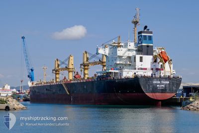
UNION TRADER
Bulk Carrier
Current Trip
| Time Travelled | 9 days |
|---|---|
| Remaining Time | --- |
| Distance Travelled | 1282.85 nm |
| Remaining Distance | --- |
| AVG Speed | 10.9 Noeuds |
| MAX Speed | 15.1 Noeuds |
| AVG Wind | 10.8 knots |
| MAX Wind | 22.8 knots |
| MIN Temp | 23.9°C / 75.02°F |
| MAX Temp | 28.6°C / 83.48°F |
| Tirant d eau | 12 m |
| Position reçue | 18 m depuis |
Current Position
| Longitude | --- |
|---|---|
| Latitude | --- |
| Etat | Under way using engine |
| Vitesse | 13.2 Noeuds |
| Parcours | 92.2° |
| Zone | Java Sea |
| Station | T-AIS |
| Position reçue | 18 m depuis |
Info
Information
The current position of UNION TRADER is in Java Sea with coordinates -4.42567° / 115.34829° as reported on 2025-12-20 16:24 by AIS to our vessel tracker app. The vessel's current speed is 13.2 Noeuds
The vessel UNION TRADER (IMO: 9445710, MMSI: 538007144) is a Bulk Carrier that was built in 2010 ( 15 Age ). It's sailing under the flag of [MH] Marshall Is.
In this page you can find informations about the vessels current position, last detected port calls, and current voyage information. If the vessels is not in coverage by AIS you will find the latest position.
The current position of UNION TRADER is detected by our AIS receivers and we are not responsible for the reliability of the data. The last position was recorded while the vessel was in Coverage by the Ais receivers of our vessel tracking app.
The current draught of UNION TRADER as reported by AIS is 12 meters
Weather
| Temperature | 28.3°C / 82.94°F |
|---|---|
| Wind Speed | 12 knots |
| Direction | 234° SW |
| Pressure | 1007 hPa |
| Humidity | 78.2 % |
| Cloud Coverage | 100 % |
Featured Company
Last Port Calls
| Port | Arrival | Departure | Time In Port |
|---|---|---|---|
| 2025-12-05 19:34 | 2025-12-11 01:17 | 5 d | |
| 2025-11-14 03:04 | 2025-11-17 13:32 | 3 d | |
| 2025-11-03 13:37 | 2025-11-13 10:00 | 9 d |
Most Visited Ports (Last year)
| Port | Arrivals | |
|---|---|---|
| 2 | ||
| 2 | ||
| 2 | ||
| 1 | ||
| 1 | ||
| 1 |
Last Trips
| Origin | Departure | Destination | Arrival | Distance | |
|---|---|---|---|---|---|
| 2025-11-17 13:32 | 2025-12-05 19:34 | 2459.04 nm | |||
| 2025-11-13 10:00 | 2025-11-14 03:04 | 201.50 nm | |||
| 2025-09-29 04:51 | 2025-11-03 13:37 | 8488.10 nm |
Events
| Heure | Evenement | Détails | Position/ Destination | Info |
|---|---|---|---|---|
| 2025-12-20 16:37 | Etat Changé | Default Under way using engine |
-4.42758 / 115.39565
WAIGAOQIAO
|
Vitesse: 13.2 kn Parcours: 92.2° |
| 2025-12-20 16:24 | Etat Changé | Under way using engine Default |
-4.42567 / 115.34829
WAIGAOQIAO
|
Vitesse: 13.3 kn Parcours: 92° |
| 2025-12-20 16:09 | Dans la zone couverte |
-4.42567 / 115.34829
Java Sea
WAIGAOQIAO
|
Vitesse: 13.2 kn Parcours: 92.2° |
|
| 2025-12-20 09:50 | Etat Changé | Default Under way using engine |
-3.84374 / 114.41691
WAIGAOQIAO
|
Vitesse: 10.7 kn Parcours: 187.6° |
| 2025-12-20 09:44 | Etat Changé | Under way using engine Default |
-3.82464 / 114.41894
WAIGAOQIAO
|
Vitesse: 8.5 kn Parcours: 188° |
| 2025-12-20 09:44 | Hors de la zone couverte |
-3.82464 / 114.41894
Java Sea
WAIGAOQIAO
|
Vitesse: 10.7 kn Parcours: 187.6° |
|
| 2025-12-20 09:02 | Etat Changé | Default Under way using engine |
-3.75756 / 114.43450
WAIGAOQIAO
|
Vitesse: 5.4 kn Parcours: 174.8° |
| 2025-12-20 08:13 | Démarrage |
-3.68767 / 114.42192
WAIGAOQIAO
|
Vitesse: 3.1 kn Parcours: 184° |
|
| 2025-12-20 08:05 | Etat Changé | Under way using engine At anchor |
-3.68510 / 114.42309
WAIGAOQIAO
|
Vitesse: 0.4 kn Parcours: 188° |
| 2025-12-20 07:40 | Etat Changé | At anchor Default |
-3.68518 / 114.42345
WAIGAOQIAO
|
Vitesse: Parcours: 194° |