
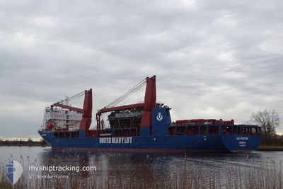
UHL FIGHTER
Cargo
Current Trip
| Time Travelled | 15 days |
|---|---|
| Remaining Time | 5 days |
| Distance Travelled | 220.29 nm |
| Remaining Distance | 1703.27 nm |
| AVG Speed | 11 Noeuds |
| MAX Speed | 15.5 Noeuds |
| AVG Wind | 7.7 knots |
| MAX Wind | 16 knots |
| MIN Temp | 24.9°C / 76.82°F |
| MAX Temp | 31.5°C / 88.7°F |
| Tirant d eau | 6.6 m |
| Position reçue | 14 h, 0 m depuis |
Current Position
| Longitude | 103.44399° |
|---|---|
| Latitude | 1.21795° |
| Etat | Under way using engine |
| Vitesse | 11.9 Noeuds |
| Parcours | 289.1° |
| Zone | Malacca Strait |
| Station | T-AIS |
| Position reçue | 14 h, 0 m depuis |
Info
Information
The current position of UHL FIGHTER is in Malacca Strait with coordinates 1.21795° / 103.44399° as reported on 2024-05-31 12:36 by AIS to our vessel tracker app. The vessel's current speed is 11.9 Noeuds and is heading at the port of TUTICORIN. The estimated time of arrival as calculated by MyShipTracking vessel tracking app is 2024-06-06 13:34 LT
The vessel UHL FIGHTER (IMO: 9892523, MMSI: 255806344) is a Cargo It's sailing under the flag of [PT] Portugal.
In this page you can find informations about the vessels current position, last detected port calls, and current voyage information. If the vessels is not in coverage by AIS you will find the latest position.
The current position of UHL FIGHTER is detected by our AIS receivers and we are not responsible for the reliability of the data. The last position was recorded while the vessel was in Coverage by the Ais receivers of our vessel tracking app.
The current draught of UHL FIGHTER as reported by AIS is 6.6 meters
Weather
| Temperature | 28.4°C / 83.12°F |
|---|---|
| Wind Speed | 7 knots |
| Direction | 154° SSE |
| Pressure | 1011.4 hPa |
| Humidity | 72.2 % |
| Cloud Coverage | 100 % |
Featured Company
Last Port Calls
| Port | Arrival | Departure | Time In Port |
|---|---|---|---|
| 2024-05-13 15:04 | 2024-05-16 11:25 | 2 d | |
| 2024-05-08 12:34 | 2024-05-13 11:41 | 4 d | |
| 2024-04-29 20:46 | 2024-05-01 19:18 | 1 d | |
| 2024-04-03 07:43 | 2024-04-03 18:15 | 10 h |
Most Visited Ports (Last year)
| Port | Arrivals | |
|---|---|---|
| 2 | ||
| 2 | ||
| 2 | ||
| 1 | ||
| 1 | ||
| 1 |
Last Trips
| Origin | Departure | Destination | Arrival | Distance | |
|---|---|---|---|---|---|
| 2024-05-13 11:41 | 2024-05-13 15:04 | 22.26 nm | |||
| 2024-05-01 19:18 | 2024-05-08 12:34 | 2139.84 nm | |||
| 2024-04-03 18:15 | 2024-04-29 20:46 | 8944.16 nm | |||
| 2024-03-20 19:16 | 2024-04-03 07:43 | 2875.81 nm |
Events
| Heure | Evenement | Détails | Position/ Destination | Info |
|---|---|---|---|---|
| 2024-05-31 12:42 | Etat Changé | Default Under way using engine |
1.22455 / 103.42520
INTUT
|
Vitesse: 11.9 kn Parcours: 289.1° |
| 2024-05-31 12:36 | Changement de zone | Malaysian part of the Malacca Strait Malaysian part of the Singapore Strait |
1.21795 / 103.44399
Malacca Strait
INTUT
|
Vitesse: 11.9 kn Parcours: 289.1° |
| 2024-05-31 12:36 | Hors de la zone couverte |
1.21795 / 103.44399
Malacca Strait
INTUT
|
Vitesse: 11.9 kn Parcours: 289.1° |
|
| 2024-05-31 12:28 | Etat Changé | Under way using engine Default |
1.21082 / 103.46937
INTUT
|
Vitesse: 11.9 kn Parcours: 283° |
| 2024-05-31 12:22 | Etat Changé | Default Under way using engine |
1.20636 / 103.48920
INTUT
|
Vitesse: 12 kn Parcours: 277.2° |
| 2024-05-31 11:52 | Changement de zone | Malaysian part of the Singapore Strait Indonesian part of the Singapore Strait |
1.19525 / 103.58771
Singapore Strait
INTUT
|
Vitesse: 12.3 kn Parcours: 281.7° |
| 2024-05-31 11:07 | Changement de zone | Indonesian part of the Singapore Strait Singaporean part of the Singapore Strait |
1.13686 / 103.73043
Singapore Strait
INTUT
|
Vitesse: 13.4 kn Parcours: 264.1° |
| 2024-05-31 10:28 | Changement de zone | Singaporean part of the Singapore Strait Indonesian part of the Singapore Strait |
1.20063 / 103.86457
Singapore Strait
INTUT
|
Vitesse: 13.3 kn Parcours: 256.5° |
| 2024-05-31 09:39 | Démarrage | 2.07 nm, North West of BATU AMPAR |
1.19291 / 103.96683
INTUT
|
Vitesse: 3.1 kn Parcours: 292° |
| 2024-05-31 09:32 | Etat Changé | Under way using engine At anchor |
1.19026 / 103.96967
INTUT
|
Vitesse: 0.2 kn Parcours: 115° |