
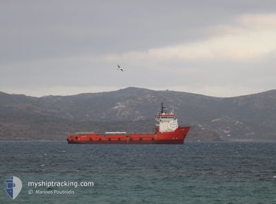
TYPHOON
Multi Purpose Offshore Vessel
Current Trip
TO ORDER
| Time Travelled | 2 days |
|---|---|
| Remaining Time | --- |
| Distance Travelled | 31.36 nm |
| Remaining Distance | --- |
| AVG Speed | 7.2 Noeuds |
| MAX Speed | 9.2 Noeuds |
| AVG Wind | 19.3 knots |
| MAX Wind | 26 knots |
| MIN Temp | 14.6°C / 58.28°F |
| MAX Temp | 19.4°C / 66.92°F |
| Tirant d eau | 3.6 m |
| Position reçue | Maintenant |
Current Position
| Longitude | 24.55509° |
|---|---|
| Latitude | 36.76835° |
| Etat | At anchor |
| Vitesse | 0.6 Noeuds |
| Parcours | 306° |
| Zone | Aegean Sea |
| Station | T-AIS |
| Position reçue | Maintenant |
Info
Information
The current position of TYPHOON is in Aegean Sea with coordinates 36.76835° / 24.55509° as reported on 2024-05-05 14:00 by AIS to our vessel tracker app. The vessel's current speed is 0.6 Noeuds
The vessel TYPHOON (IMO: 9303481, MMSI: 373844000) is a Multi Purpose Offshore Vessel that was built in 2004 ( 20 Age ). It's sailing under the flag of [PA] Panama.
In this page you can find informations about the vessels current position, last detected port calls, and current voyage information. If the vessels is not in coverage by AIS you will find the latest position.
The current position of TYPHOON is detected by our AIS receivers and we are not responsible for the reliability of the data. The last position was recorded while the vessel was in Coverage by the Ais receivers of our vessel tracking app.
The current draught of TYPHOON as reported by AIS is 3.6 meters
Weather
| Temperature | 17.1°C / 62.78°F |
|---|---|
| Wind Speed | 24 knots |
| Direction | 6° N |
| Pressure | 1014.8 hPa |
| Humidity | 79.1 % |
| Cloud Coverage | --- |
Featured Company
Most Visited Ports (Last year)
| Port | Arrivals | |
|---|---|---|
| 5 | ||
| 5 | ||
| 4 | ||
| 1 | ||
| 1 |
Events
| Heure | Evenement | Détails | Position/ Destination | Info |
|---|---|---|---|---|
| 2024-05-04 09:36 | Etat Changé | At anchor Under way using engine |
36.76981 / 24.55570
TO ORDER
|
Vitesse: 0.7 kn Parcours: 305° |
| 2024-05-04 09:34 | Arret | 1.38 nm, East of POLLONIA |
36.76980 / 24.55542
TO ORDER
|
Vitesse: 0.3 kn Parcours: 327° |
| 2024-05-04 07:47 | Démarrage | 1.5 nm, North of POLYAIGOS |
36.80969 / 24.60823
TO ORDER
|
Vitesse: 7.3 kn Parcours: 119.7° |
| 2024-05-04 07:47 | Etat Changé | Under way using engine At anchor |
36.81000 / 24.60752
TO ORDER
|
Vitesse: 5.6 kn Parcours: 117.7° |
| 2024-05-03 11:39 | Arret | 1.6 nm, North of POLYAIGOS |
36.81123 / 24.60639
TO ORDER
|
Vitesse: 0.2 kn Parcours: 273° |
| 2024-05-03 11:30 | Etat Changé | At anchor Under way using engine |
36.81124 / 24.60512
TO ORDER
|
Vitesse: 1.4 kn Parcours: 136° |
| 2024-05-03 11:25 | Démarrage | 1.78 nm, North of POLYAIGOS |
36.81384 / 24.60335
TO ORDER
|
Vitesse: 6.6 kn Parcours: 174.3° |
| 2024-05-03 11:23 | Arret | 1.89 nm, North of POLYAIGOS |
36.81569 / 24.60240
TO ORDER
|
Vitesse: 0.3 kn Parcours: 236° |
| 2024-05-03 10:31 | Démarrage | 0.99 nm, South East of VOUDIA |
36.73808 / 24.55070
TO ORDER
|
Vitesse: 4.4 kn Parcours: 70° |
| 2024-05-03 10:29 | Etat Changé | Under way using engine At anchor |
36.73813 / 24.54881
TO ORDER
|
Vitesse: 1 kn Parcours: 318° |