

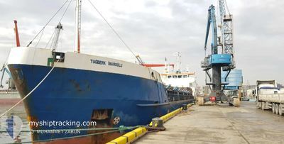
TUGBERK IMAMOGLU
General Cargo

Current Trip
| Time Travelled | 1 day |
|---|---|
| Remaining Time | --- |
| Distance Travelled | 75.08 nm |
| Remaining Distance | --- |
| AVG Speed | 8.6 Noeuds |
| MAX Speed | 9.3 Noeuds |
| AVG Wind | 7.1 knots |
| MAX Wind | 12.3 knots |
| MIN Temp | 19.1°C / 66.38°F |
| MAX Temp | 20.6°C / 69.08°F |
| Tirant d eau | 4.7 m |
| Position reçue | 1 d depuis |
Current Position
| Longitude | --- |
|---|---|
| Latitude | --- |
| Etat | Under way using engine |
| Vitesse | 9.1 Noeuds |
| Parcours | 256.2° |
| Zone | Mediterranean Sea - Eastern Basin |
| Station | T-AIS |
| Position reçue | 1 d depuis |
Information
The current position of TUGBERK IMAMOGLU is in Mediterranean Sea - Eastern Basin with coordinates 36.29214° / 34.71118° as reported on 2025-03-28 01:33 by AIS to our vessel tracker app. The vessel's current speed is 9.1 Noeuds and is heading at the port of SAGUNTO. The estimated time of arrival as calculated by MyShipTracking vessel tracking app is 2025-04-05 14:00 LT
The vessel TUGBERK IMAMOGLU (IMO: 9003548, MMSI: 271044604) is a General Cargo that was built in 1990 ( 35 Age ). It's sailing under the flag of [TR] Turkey.
In this page you can find informations about the vessels current position, last detected port calls, and current voyage information. If the vessels is not in coverage by AIS you will find the latest position.
The current position of TUGBERK IMAMOGLU is detected by our AIS receivers and we are not responsible for the reliability of the data. The last position was recorded while the vessel was in Coverage by the Ais receivers of our vessel tracking app.
The current draught of TUGBERK IMAMOGLU as reported by AIS is 4.7 meters
Weather
| Temperature | 17.4°C / 63.32°F |
|---|---|
| Wind Speed | 15 knots |
| Direction | 239° WSW |
| Pressure | 1005.5 hPa |
| Humidity | 79.5 % |
| Cloud Coverage | --- |


Featured Company
Last Port Calls
| Port | Arrival | Departure | Time In Port |
|---|---|---|---|
| 2025-03-26 09:18 | 2025-03-27 16:46 | 1 d | |
| 2025-03-20 07:46 | 2025-03-21 11:14 | 1 d | |
| 2025-03-10 14:02 | 2025-03-12 17:29 | 2 d | |
| 2025-03-04 06:43 | 2025-03-06 09:48 | 2 d | |
| 2025-02-19 10:53 | 2025-02-24 23:10 | 5 d | |
| 2025-02-18 05:59 | 2025-02-18 23:58 | 17 h | |
| 2025-02-11 13:03 | 2025-02-15 02:04 | 3 d | |
| 2025-02-03 07:04 | 2025-02-07 12:46 | 4 d | |
| 2025-01-29 16:34 | 2025-01-31 14:00 | 1 d | |
| 2025-01-27 13:48 | 2025-01-28 21:41 | 1 d |
Most Visited Ports (Last year)
| Port | Arrivals | |
|---|---|---|
| 18 | ||
| 9 | ||
| 8 | ||
| 5 | ||
| 5 | ||
| 5 |
Last Trips
| Origin | Departure | Destination | Arrival | Distance | |
|---|---|---|---|---|---|
| 2025-03-21 12:14 | 2025-03-26 12:18 | 1058.72 nm | |||
| 2025-03-12 20:29 | 2025-03-20 08:46 | 1070.27 nm | |||
| 2025-03-06 11:48 | 2025-03-10 17:02 | 531.60 nm | |||
| 2025-02-25 02:10 | 2025-03-04 08:43 | 672.59 nm | |||
| 2025-02-19 02:58 | 2025-02-19 13:53 | 89.40 nm | |||
| 2025-02-15 05:04 | 2025-02-18 08:59 | 557.18 nm | |||
| 2025-02-07 14:46 | 2025-02-11 16:03 | 269.70 nm | |||
| 2025-01-31 17:00 | 2025-02-03 09:04 | 374.37 nm | |||
| 2025-01-29 00:41 | 2025-01-29 19:34 | 60.17 nm | |||
| 2025-01-26 00:33 | 2025-01-27 16:48 | 68.96 nm |
Events
| Heure | Evenement | Détails | Position/ Destination | Info |
|---|---|---|---|---|
| 2025-03-28 01:35 | Etat Changé | Default Under way using engine |
36.29127 / 34.70658
ES SAG
|
Vitesse: 9.1 kn Parcours: 256.2° |
| 2025-03-28 01:33 | Hors de la zone couverte |
36.29214 / 34.71118
Mediterranean Sea - Eastern Basin
ES SAG
|
Vitesse: 9.1 kn Parcours: 256.2° |
|
| 2025-03-27 22:59 | Etat Changé | Under way using engine Default |
36.36940 / 35.18200
ES SAG
|
Vitesse: 8.9 kn Parcours: 259° |
| 2025-03-27 22:36 | Etat Changé | Default Under way using engine |
36.37999 / 35.25111
ES SAG
|
Vitesse: 9 kn Parcours: 260.5° |
| 2025-03-27 18:53 | Tirant d'eau modifié | 4.7 2.7 |
36.56500 / 35.85333
ES SAG
|
Vitesse: 8.3 kn Parcours: 230.7° |
| 2025-03-27 18:53 | Changement de destination | ES SAG TR ISK |
36.56500 / 35.85333
ES SAG
|
Vitesse: 8.3 kn Parcours: 230.7° |
| 2025-03-27 18:53 | Changement d'ETA | 2025/04/05 14:00 2025/03/26 02:00 |
36.56500 / 35.85333
ES SAG
|
Vitesse: 8.3 kn Parcours: 230.7° |
| 2025-03-27 18:53 | Etat Changé | Under way using engine Default |
36.56500 / 35.85333
TR ISK
|
Vitesse: 8.6 kn Parcours: 236° |
| 2025-03-27 18:53 | Dans la zone couverte |
36.56134 / 35.84779
Mediterranean Sea - Eastern Basin
ES SAG
|
Vitesse: 8.3 kn Parcours: 231.2° |
|
| 2025-03-27 16:46 | PORT DE DEPART |
|
36.68555 / 36.14206
TR ISK
|
Vitesse: 6.7 kn Parcours: 225° |