
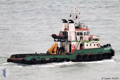
TUG GREEN CHIEF
Tug
Current Trip
| Time Travelled | 13 days |
|---|---|
| Remaining Time | --- |
| Distance Travelled | 497.79 nm |
| Remaining Distance | --- |
| AVG Speed | 4.1 Noeuds |
| MAX Speed | 6.3 Noeuds |
| AVG Wind | 10.8 knots |
| MAX Wind | 15 knots |
| MIN Temp | 26.8°C / 80.24°F |
| MAX Temp | 28.6°C / 83.48°F |
| Tirant d eau | 3.2 m |
| Position reçue | 17 h, 25 m depuis |
Current Position
| Longitude | -62.74071° |
|---|---|
| Latitude | 17.20678° |
| Etat | Restricted manoeuverability |
| Vitesse | 1.8 Noeuds |
| Parcours | 111° |
| Zone | Caribbean Sea |
| Station | T-AIS |
| Position reçue | 17 h, 25 m depuis |
Info
Information
The current position of TUG GREEN CHIEF is in Caribbean Sea with coordinates 17.20678° / -62.74071° as reported on 2024-05-21 12:09 by AIS to our vessel tracker app. The vessel's current speed is 1.8 Noeuds
The vessel TUG GREEN CHIEF (IMO: 8008163, MMSI: 671219100) is a Tug that was built in 1980 ( 44 Age ). It's sailing under the flag of [TG] Togo.
In this page you can find informations about the vessels current position, last detected port calls, and current voyage information. If the vessels is not in coverage by AIS you will find the latest position.
The current position of TUG GREEN CHIEF is detected by our AIS receivers and we are not responsible for the reliability of the data. The last position was recorded while the vessel was in Coverage by the Ais receivers of our vessel tracking app.
The current draught of TUG GREEN CHIEF as reported by AIS is 3.2 meters
Weather
| Temperature | 28.6°C / 83.48°F |
|---|---|
| Wind Speed | 14 knots |
| Direction | 107° ESE |
| Pressure | 1014.6 hPa |
| Humidity | 72.2 % |
| Cloud Coverage | 7 % |
Featured Company
Last Port Calls
| Port | Arrival | Departure | Time In Port |
|---|---|---|---|
| 2024-05-06 20:16 | 2024-05-08 11:52 | 1 d | |
| 2024-05-01 17:50 | 2024-05-05 14:36 | 3 d | |
| 2024-04-30 03:36 | |||
| 2024-04-23 16:13 | 2024-04-26 21:09 | 3 d | |
| 2024-04-21 14:28 | 2024-04-21 21:16 | 6 h | |
| 2024-04-08 13:14 | 2024-04-21 13:05 | 12 d | |
| 2024-04-06 21:09 | 2024-04-07 16:13 | 19 h | |
| 2024-03-26 12:03 | 2024-03-26 23:00 | 10 h | |
| 2024-03-24 20:58 | |||
| 2024-03-13 11:56 | 2024-03-13 22:37 | 10 h |
Most Visited Ports (Last year)
| Port | Arrivals | |
|---|---|---|
| 37 | ||
| 5 | ||
| 3 | ||
| 2 | ||
| 1 | ||
| 1 |
Last Trips
| Origin | Departure | Destination | Arrival | Distance | |
|---|---|---|---|---|---|
| 2024-05-05 10:36 | 2024-05-06 16:16 | 31.28 nm | |||
| 2024-04-29 23:36 | 2024-05-01 13:50 | 98.87 nm | |||
| 2024-04-21 17:16 | 2024-04-23 12:13 | 147.43 nm | |||
| 2024-04-21 09:05 | 2024-04-21 10:28 | 9.76 nm | |||
| 2024-04-07 12:13 | 2024-04-08 09:14 | 107.63 nm | |||
| 2024-03-26 19:00 | 2024-04-06 17:09 | 411.05 nm | |||
| 2024-03-24 16:58 | 2024-03-26 08:03 | 142.85 nm |
Events
| Heure | Evenement | Détails | Position/ Destination | Info |
|---|---|---|---|---|
| 2024-05-21 12:09 | Hors de la zone couverte |
17.20678 / -62.74071
Caribbean Sea
MONTSERRAT
|
Vitesse: 1.8 kn Parcours: 106.2° |
|
| 2024-05-21 11:58 | Detecté en mer | Saint Kitts and Nevis part of the Caribbean Sea |
17.20835 / -62.74588
Caribbean Sea
MONTSERRAT
|
Vitesse: 1.6 kn Parcours: 107° |
| 2024-05-21 11:58 | Dans la zone couverte |
17.20835 / -62.74588
Caribbean Sea
MONTSERRAT
|
Vitesse: 1.6 kn Parcours: 107° |
|
| 2024-05-21 03:29 | Hors de la zone couverte |
17.63317 / -63.15025
Caribbean Sea
MONTSERRAT
|
Vitesse: 4.4 kn Parcours: 143.1° |
|
| 2024-05-21 01:54 | Changement de zone | Saba part of the Caribbean Sea Puerto Rican part of the Caribbean Sea |
17.71016 / -63.23297
Caribbean Sea
MONTSERRAT
|
Vitesse: 4.3 kn Parcours: 130.8° |
| 2024-05-21 01:53 | Dans la zone couverte |
17.71016 / -63.23297
Caribbean Sea
MONTSERRAT
|
Vitesse: 4.3 kn Parcours: 130.8° |
|
| 2024-05-20 03:50 | Hors de la zone couverte |
18.22467 / -64.89184
Caribbean Sea
MONTSERRAT
|
Vitesse: 5.4 kn Parcours: 125.9° |
|
| 2024-05-20 03:06 | Changement de destination | MONTSERRAT ST THOMAS |
18.26923 / -64.94686
MONTSERRAT
|
Vitesse: 5.5 kn Parcours: 133.4° |
| 2024-05-20 03:06 | Changement d'ETA | 2024/05/21 23:00 2025/02/15 17:30 |
18.26923 / -64.94686
MONTSERRAT
|
Vitesse: 5.5 kn Parcours: 133.4° |
| 2024-05-20 02:58 | Dans la zone couverte |
18.27646 / -64.95420
Caribbean Sea
|
Vitesse: 5.5 kn Parcours: 137.7° |