

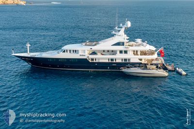
TREEHOUSE
Pleasure Craft

Current Trip
| Trip Time | 7 days |
|---|---|
| Trip Distance | 967.66 nm |
| AVG Speed | 11.1 Noeuds |
| MAX Speed | 13.8 Noeuds |
| Tirant d eau | 3.8 m |
| AVG Wind | 8 knots |
| MAX Wind | 15 knots |
| MIN Temp | 14.1°C / 57.38°F |
| MAX Temp | 21.9°C / 71.42°F |
| Position reçue | 3 d depuis |
Current Position
| Longitude | --- |
|---|---|
| Latitude | --- |
| Etat | Under way using engine |
| Vitesse | 0.8 Noeuds |
| Parcours | 212° |
| Zone | North Pacific Ocean |
| Station | T-AIS |
| Position reçue | 3 d depuis |
Information
The current position of TREEHOUSE is in North Pacific Ocean with coordinates 32.70379° / -117.16203° as reported on 2025-03-15 15:16 by AIS to our vessel tracker app. The vessel's current speed is 0.8 Noeuds and is currently inside the port of SAN DIEGO.
The vessel TREEHOUSE (IMO: 1006805, MMSI: 319135800) is a Pleasure Craft It's sailing under the flag of [KY] Cayman Is.
In this page you can find informations about the vessels current position, last detected port calls, and current voyage information. If the vessels is not in coverage by AIS you will find the latest position.
The current position of TREEHOUSE is detected by our AIS receivers and we are not responsible for the reliability of the data. The last position was recorded while the vessel was in Coverage by the Ais receivers of our vessel tracking app.
The current draught of TREEHOUSE as reported by AIS is 3.8 meters
Weather
| Temperature | 12.3°C / 54.14°F |
|---|---|
| Wind Speed | 8 knots |
| Direction | 293° WNW |
| Pressure | 1017.1 hPa |
| Humidity | 76.4 % |
| Cloud Coverage | 68 % |


Featured Company
Last Port Calls
| Port | Arrival | Departure | Time In Port |
|---|---|---|---|
| 2025-03-12 13:48 | |||
| 2025-03-05 06:02 |
Last Trips
| Origin | Departure | Destination | Arrival | Distance | |
|---|---|---|---|---|---|
| 2025-03-05 06:02 | 2025-03-12 13:48 | 967.66 nm |
Events
| Heure | Evenement | Détails | Position/ Destination | Info |
|---|---|---|---|---|
| 2025-03-15 15:16 | Hors de la zone couverte |
32.70379 / -117.16203
North Pacific Ocean
[US] SAN DIEGO
|
Vitesse: 0.8 kn Parcours: 27.2° |
|
| 2025-03-15 15:07 | Dans la zone couverte |
32.70399 / -117.16221
North Pacific Ocean
[US] SAN DIEGO
|
Vitesse: 0.8 kn Parcours: 210.1° |
|
| 2025-03-15 13:59 | Hors de la zone couverte |
32.70423 / -117.16195
North Pacific Ocean
[US] SAN DIEGO
|
Vitesse: Parcours: 35.3° |
|
| 2025-03-15 13:47 | Dans la zone couverte |
32.70422 / -117.16195
North Pacific Ocean
[US] SAN DIEGO
|
Vitesse: Parcours: 35.3° |
|
| 2025-03-15 10:35 | Hors de la zone couverte |
32.70423 / -117.16195
North Pacific Ocean
[US] SAN DIEGO
|
Vitesse: Parcours: 35.3° |
|
| 2025-03-15 10:17 | Dans la zone couverte |
32.70423 / -117.16194
North Pacific Ocean
[US] SAN DIEGO
|
Vitesse: Parcours: 35.3° |
|
| 2025-03-15 07:47 | Hors de la zone couverte |
32.70423 / -117.16194
North Pacific Ocean
[US] SAN DIEGO
|
Vitesse: Parcours: 35.3° |
|
| 2025-03-15 05:47 | Dans la zone couverte |
32.70421 / -117.16194
North Pacific Ocean
[US] SAN DIEGO
|
Vitesse: Parcours: 35.3° |
|
| 2025-03-14 03:04 | Hors de la zone couverte |
32.70426 / -117.16198
North Pacific Ocean
[US] SAN DIEGO
|
Vitesse: Parcours: 35.3° |
|
| 2025-03-14 03:04 | Dans la zone couverte |
32.70426 / -117.16198
North Pacific Ocean
[US] SAN DIEGO
|
Vitesse: Parcours: 35.3° |