

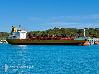
TINERFE
Oil/Chemical Tanker

Current Trip
| Time Travelled | 1 day |
|---|---|
| Remaining Time | --- |
| Distance Travelled | 191.79 nm |
| Remaining Distance | --- |
| AVG Speed | 11.7 Noeuds |
| MAX Speed | 15 Noeuds |
| AVG Wind | 11.1 knots |
| MAX Wind | 15 knots |
| MIN Temp | 10.2°C / 50.36°F |
| MAX Temp | 17.5°C / 63.5°F |
| Tirant d eau | 6 m |
| Position reçue | 3 m depuis |
Current Position
| Longitude | --- |
|---|---|
| Latitude | --- |
| Etat | At anchor |
| Vitesse | |
| Parcours | 267° |
| Zone | Strait of Gibraltar |
| Station | T-AIS |
| Position reçue | 3 m depuis |
Information
The current position of TINERFE is in Strait of Gibraltar with coordinates 36.15680° / -5.42807° as reported on 2025-02-22 19:20 by AIS to our vessel tracker app. The vessel's current speed is 0 Noeuds and is heading at the port of ALGECIRAS. The estimated time of arrival as calculated by MyShipTracking vessel tracking app is 2025-02-21 06:00 LT
The vessel TINERFE (IMO: 9498107, MMSI: 255831000) is a Oil/Chemical Tanker that was built in 2009 ( 16 Age ). It's sailing under the flag of [PT] Portugal.
In this page you can find informations about the vessels current position, last detected port calls, and current voyage information. If the vessels is not in coverage by AIS you will find the latest position.
The current position of TINERFE is detected by our AIS receivers and we are not responsible for the reliability of the data. The last position was recorded while the vessel was in Coverage by the Ais receivers of our vessel tracking app.
The current draught of TINERFE as reported by AIS is 6 meters
Weather
| Temperature | 10.5°C / 50.9°F |
|---|---|
| Wind Speed | 5 knots |
| Direction | 269° W |
| Pressure | 1024.6 hPa |
| Humidity | 92.3 % |
| Cloud Coverage | --- |


Featured Company
Last Port Calls
| Port | Arrival | Departure | Time In Port |
|---|---|---|---|
| 2025-02-19 20:51 | 2025-02-20 21:59 | 1 d | |
| 2025-02-17 18:16 | 2025-02-19 08:18 | 1 d | |
| 2025-02-15 15:34 | 2025-02-16 19:10 | 1 d | |
| 2025-02-13 12:02 | 2025-02-14 06:28 | 18 h | |
| 2025-02-10 02:15 | 2025-02-10 02:46 | 31 m | |
| 2025-02-07 19:58 | 2025-02-08 09:20 | 13 h | |
| 2025-02-06 16:16 | 2025-02-07 14:00 | 21 h | |
| 2025-02-05 00:33 | 2025-02-06 05:26 | 1 d | |
| 2025-02-03 22:56 | 2025-02-04 14:40 | 15 h | |
| 2025-02-02 01:33 | 2025-02-02 18:50 | 17 h |
Most Visited Ports (Last year)
| Port | Arrivals | |
|---|---|---|
| 31 | ||
| 25 | ||
| 23 | ||
| 22 | ||
| 20 | ||
| 18 |
Last Trips
| Origin | Departure | Destination | Arrival | Distance | |
|---|---|---|---|---|---|
| 2025-02-19 08:18 | 2025-02-19 20:51 | 156.64 nm | |||
| 2025-02-16 19:10 | 2025-02-17 18:16 | 302.96 nm | |||
| 2025-02-14 06:28 | 2025-02-15 15:34 | 452.05 nm | |||
| 2025-02-10 02:46 | 2025-02-13 12:02 | 242.49 nm | |||
| 2025-02-08 09:20 | 2025-02-10 02:15 | 523.55 nm | |||
| 2025-02-07 14:00 | 2025-02-07 19:58 | 72.26 nm | |||
| 2025-02-06 05:26 | 2025-02-06 16:16 | 131.09 nm | |||
| 2025-02-04 14:40 | 2025-02-05 00:33 | 131.53 nm | |||
| 2025-02-02 18:50 | 2025-02-03 22:56 | 372.10 nm | |||
| 2025-02-01 12:19 | 2025-02-02 01:33 | 106.71 nm |
Events
| Heure | Evenement | Détails | Position/ Destination | Info |
|---|---|---|---|---|
| 2025-02-21 17:23 | Arret | 1.24 nm, South of PALMONES |
36.15630 / -5.42943
ES ALG
|
Vitesse: 0.3 kn Parcours: 306° |
| 2025-02-21 17:21 | Etat Changé | At anchor Under way using engine |
36.15660 / -5.42925
ES ALG
|
Vitesse: 0.7 kn Parcours: 291° |
| 2025-02-21 17:08 | Changement de zone | Spanish part of the Strait of Gibraltar Gibraltarian part of the Strait of Gibraltar |
36.14593 / -5.40467
Strait of Gibraltar
|
Vitesse: 10.3 kn Parcours: 307.5° |
| 2025-02-21 16:34 | Changement de zone | Gibraltarian part of the Strait of Gibraltar Gibraltarian part of the Alboran Sea |
36.07919 / -5.34128
Strait of Gibraltar
|
Vitesse: 13.1 kn Parcours: 252.7° |
| 2025-02-21 15:48 | Changement de zone | Gibraltarian part of the Alboran Sea Spanish part of the Alboran Sea |
36.13938 / -5.13522
Alboran Sea
|
Vitesse: 13.4 kn Parcours: 243.3° |
| 2025-02-21 15:25 | Démarrage | 15.01 nm, East of GIBRALTAR |
36.17283 / -5.05535
ES ALG
|
Vitesse: 3.2 kn Parcours: 205° |
| 2025-02-21 13:58 | Arret | 16.51 nm, East of GIBRALTAR |
36.18865 / -5.02660
ES ALG
|
Vitesse: 0.3 kn Parcours: 150° |
| 2025-02-21 03:44 | Changement de zone | Spanish part of the Alboran Sea Gibraltarian part of the Alboran Sea |
36.15013 / -5.20524
Alboran Sea
ES ALG
|
Vitesse: 13.2 kn Parcours: 67° |
| 2025-02-21 03:14 | Changement de zone | Gibraltarian part of the Alboran Sea Spanish part of the Alboran Sea |
36.13918 / -5.16334
Alboran Sea
ES ALG
|
Vitesse: 14.4 kn Parcours: 247° |
| 2025-02-20 22:54 | Changement d'ETA | 2025/02/21 05:00 2025/02/21 10:00 |
36.52163 / -3.99644
ES ALG
|
Vitesse: 14.3 kn Parcours: 248.2° |