

TIMBUS
General Cargo

Current Trip
| Time Travelled | 1 day |
|---|---|
| Remaining Time | 6 h, 40 mins |
| Distance Travelled | 246.10 nm |
| Remaining Distance | 77.60 nm |
| AVG Speed | 10.4 Noeuds |
| MAX Speed | 11.6 Noeuds |
| AVG Wind | 25.2 knots |
| MAX Wind | 30 knots |
| MIN Temp | 3.3°C / 37.94°F |
| MAX Temp | 11.6°C / 52.88°F |
| Tirant d eau | 5 m |
| Position reçue | Maintenant |
Current Position
| Longitude | --- |
|---|---|
| Latitude | --- |
| Etat | Under way using engine |
| Vitesse | 11.1 Noeuds |
| Parcours | 38.7° |
| Zone | Baltic Sea |
| Station | T-AIS |
| Position reçue | Maintenant |
Information
The current position of TIMBUS is in Baltic Sea with coordinates 56.10910° / 16.01991° as reported on 2025-03-23 11:41 by AIS to our vessel tracker app. The vessel's current speed is 11.1 Noeuds and is heading at the port of MONSTERAS. The estimated time of arrival as calculated by MyShipTracking vessel tracking app is 2025-03-23 19:22 LT
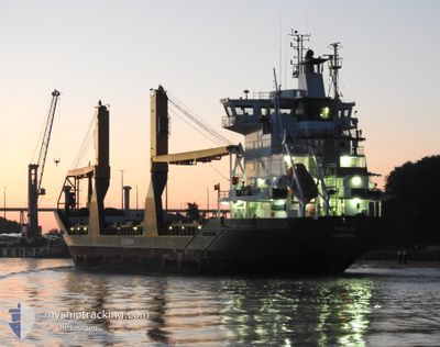
The vessel TIMBUS (IMO: 9198680, MMSI: 211317180) is a General Cargo that was built in 1999 ( 26 Age ). It's sailing under the flag of [DE] Germany.
In this page you can find informations about the vessels current position, last detected port calls, and current voyage information. If the vessels is not in coverage by AIS you will find the latest position.
The current position of TIMBUS is detected by our AIS receivers and we are not responsible for the reliability of the data. The last position was recorded while the vessel was in Coverage by the Ais receivers of our vessel tracking app.
The current draught of TIMBUS as reported by AIS is 5 meters
Weather
| Temperature | 3.5°C / 38.3°F |
|---|---|
| Wind Speed | 23 knots |
| Direction | 93° E |
| Pressure | 1018.7 hPa |
| Humidity | 88.1 % |
| Cloud Coverage | --- |


Featured Company
Last Port Calls
| Port | Arrival | Departure | Time In Port |
|---|---|---|---|
| 2025-03-22 12:25 | 2025-03-22 12:28 | 3 m | |
| 2025-03-20 16:54 | 2025-03-21 15:12 | 22 h | |
| 2025-03-18 05:48 | 2025-03-18 14:22 | 8 h | |
| 2025-03-15 00:49 | 2025-03-15 16:15 | 15 h | |
| 2025-03-12 05:51 | 2025-03-12 16:16 | 10 h | |
| 2025-03-11 05:59 | 2025-03-11 13:06 | 7 h | |
| 2025-03-10 09:54 | 2025-03-10 09:58 | 4 m | |
| 2025-03-08 00:55 | 2025-03-08 23:08 | 22 h | |
| 2025-03-03 05:58 | 2025-03-03 22:16 | 16 h | |
| 2025-03-01 05:44 | 2025-03-01 21:15 | 15 h |
Last Trips
| Origin | Departure | Destination | Arrival | Distance | |
|---|---|---|---|---|---|
| 2025-03-21 15:12 | 2025-03-22 12:25 | 159.91 nm | |||
| 2025-03-18 14:22 | 2025-03-20 16:54 | 527.01 nm | |||
| 2025-03-15 16:15 | 2025-03-18 05:48 | 685.12 nm | |||
| 2025-03-12 16:16 | 2025-03-15 00:49 | 562.97 nm | |||
| 2025-03-11 13:06 | 2025-03-12 05:51 | 225.96 nm | |||
| 2025-03-10 09:58 | 2025-03-11 05:59 | 230.02 nm | |||
| 2025-03-08 23:08 | 2025-03-10 09:54 | 360.34 nm | |||
| 2025-03-03 22:16 | 2025-03-08 00:55 | 753.63 nm | |||
| 2025-03-01 21:15 | 2025-03-03 05:58 | 363.00 nm | |||
| 2025-02-27 21:19 | 2025-03-01 05:44 | 421.70 nm |
Events
| Heure | Evenement | Détails | Position/ Destination | Info |
|---|---|---|---|---|
| 2025-03-23 07:52 | Detecté en mer | Swedish part of the Baltic Sea |
55.67368 / 15.13689
Baltic Sea
SEJAT
|
Vitesse: 10.6 kn Parcours: 53.4° |
| 2025-03-23 02:58 | Changement de zone | Danish part of the Kattegat Swedish part of the Baltic Sea |
55.02622 / 14.08126
Kattegat
SEJAT
|
Vitesse: 11 kn Parcours: 70.2° |
| 2025-03-23 02:25 | Changement de zone | Swedish part of the Baltic Sea German part of the Baltic Sea |
54.99051 / 13.91486
Baltic Sea
SEJAT
|
Vitesse: 11 kn Parcours: 71.8° |
| 2025-03-22 22:32 | Tirant d'eau modifié | 5 4.8 |
54.72393 / 12.81158
SEJAT
|
Vitesse: 10.7 kn Parcours: 56.5° |
| 2025-03-22 19:31 | Changement de zone | German part of the Baltic Sea Danish part of the Baltic Sea |
54.40785 / 12.10028
Baltic Sea
SEJAT
|
Vitesse: 9.8 kn Parcours: 80.1° |
| 2025-03-22 16:43 | Detecté en mer | Danish part of the Baltic Sea |
54.50754 / 11.42996
Baltic Sea
SEJAT
|
Vitesse: 8.7 kn Parcours: 118.6° |
| 2025-03-22 13:56 | Detecté en mer | German part of the Baltic Sea |
54.56081 / 10.76174
Baltic Sea
SEJAT
|
Vitesse: 9.8 kn Parcours: 81.6° |
| 2025-03-22 13:29 | Changement de zone | Danish part of the Baltic Sea German part of the Baltic Sea |
54.55127 / 10.63575
Baltic Sea
SEJAT
|
Vitesse: 9.9 kn Parcours: 82.6° |
| 2025-03-22 12:08 | Changement de zone | German part of the Baltic Sea German part of the North Sea |
54.46464 / 10.27972
Baltic Sea
SEJAT
|
Vitesse: 11 kn Parcours: 40.8° |
| 2025-03-22 11:28 | PORT DE DEPART |
|
54.36415 / 10.17185
SEJAT
|
Vitesse: 9.7 kn Parcours: 38° |