
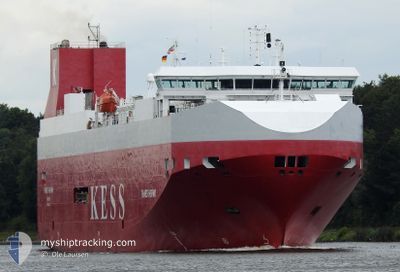
THAMES HIGHWAY
Vehicles Carrier
Current Trip
| Time Travelled | 2 days |
|---|---|
| Remaining Time | 15 h, 59 mins |
| Distance Travelled | 379.59 nm |
| Remaining Distance | 165.70 nm |
| AVG Speed | 10.8 Noeuds |
| MAX Speed | 16.5 Noeuds |
| AVG Wind | 9.8 knots |
| MAX Wind | 17 knots |
| MIN Temp | 11.1°C / 51.98°F |
| MAX Temp | 21°C / 69.8°F |
| Tirant d eau | 7.5 m |
| Position reçue | 19 m depuis |
Current Position
| Longitude | 4.54026° |
|---|---|
| Latitude | 53.48156° |
| Etat | Under way using engine |
| Vitesse | 10 Noeuds |
| Parcours | 279.2° |
| Zone | North Sea |
| Station | T-AIS |
| Position reçue | 19 m depuis |
Info
Information
The current position of THAMES HIGHWAY is in North Sea with coordinates 53.48156° / 4.54026° as reported on 2024-05-03 07:11 by AIS to our vessel tracker app. The vessel's current speed is 10 Noeuds and is heading at the port of GRIMSBY. The estimated time of arrival as calculated by MyShipTracking vessel tracking app is 2024-05-03 23:30 LT
The vessel THAMES HIGHWAY (IMO: 9316294, MMSI: 311996000) is a Vehicles Carrier that was built in 2005 ( 19 Age ). It's sailing under the flag of [BS] Bahamas.
In this page you can find informations about the vessels current position, last detected port calls, and current voyage information. If the vessels is not in coverage by AIS you will find the latest position.
The current position of THAMES HIGHWAY is detected by our AIS receivers and we are not responsible for the reliability of the data. The last position was recorded while the vessel was in Coverage by the Ais receivers of our vessel tracking app.
The current draught of THAMES HIGHWAY as reported by AIS is 7.5 meters
Weather
| Temperature | 11.1°C / 51.98°F |
|---|---|
| Wind Speed | 8 knots |
| Direction | 113° ESE |
| Pressure | 1002.7 hPa |
| Humidity | 97.8 % |
| Cloud Coverage | 26 % |
Featured Company
Last Port Calls
| Port | Arrival | Departure | Time In Port |
|---|---|---|---|
| 2024-04-29 21:37 | 2024-04-30 08:19 | 10 h | |
| 2024-04-27 03:02 | 2024-04-27 17:56 | 14 h | |
| 2024-04-25 16:59 | 2024-04-26 06:42 | 13 h | |
| 2024-04-24 09:22 | 2024-04-24 20:19 | 10 h | |
| 2024-04-18 19:38 | 2024-04-19 13:24 | 17 h | |
| 2024-04-15 22:59 | 2024-04-16 12:52 | 13 h | |
| 2024-04-14 10:28 | 2024-04-15 05:21 | 18 h | |
| 2024-04-13 02:19 | 2024-04-13 15:21 | 13 h | |
| 2024-04-11 16:27 | 2024-04-12 06:46 | 14 h | |
| 2024-04-10 09:20 | 2024-04-10 20:10 | 10 h |
Last Trips
| Origin | Departure | Destination | Arrival | Distance | |
|---|---|---|---|---|---|
| 2024-04-27 19:56 | 2024-04-29 23:37 | 493.47 nm | |||
| 2024-04-26 07:42 | 2024-04-27 05:02 | 333.89 nm | |||
| 2024-04-24 22:19 | 2024-04-25 17:59 | 336.17 nm | |||
| 2024-04-19 15:24 | 2024-04-24 11:22 | 561.96 nm | |||
| 2024-04-16 14:52 | 2024-04-18 21:38 | 549.17 nm | |||
| 2024-04-15 06:21 | 2024-04-16 00:59 | 275.56 nm | |||
| 2024-04-13 17:21 | 2024-04-14 11:28 | 281.02 nm | |||
| 2024-04-12 07:46 | 2024-04-13 04:19 | 333.78 nm | |||
| 2024-04-10 22:10 | 2024-04-11 17:27 | 337.20 nm | |||
| 2024-04-08 00:46 | 2024-04-10 11:20 | 550.80 nm |
Events
| Heure | Evenement | Détails | Position/ Destination | Info |
|---|---|---|---|---|
| 2024-05-03 07:14 | Etat Changé | Default Under way using engine |
53.48301 / 4.52740
GBGSY
|
Vitesse: 10 kn Parcours: 279.2° |
| 2024-05-03 07:08 | Etat Changé | Under way using engine Default |
53.48081 / 4.55701
GBGSY
|
Vitesse: 10 kn Parcours: 254° |
| 2024-05-03 07:01 | Etat Changé | Default Under way using engine |
53.48500 / 4.58500
GBGSY
|
Vitesse: 10 kn Parcours: 253.7° |
| 2024-05-02 23:24 | Changement d'ETA | 2024/05/03 00:01 2024/05/03 02:00 |
53.62621 / 6.35515
GBGSY
|
Vitesse: 9.6 kn Parcours: 271° |
| 2024-05-02 22:52 | Changement de zone | Dutch part of the North Sea German part of the North Sea |
53.61382 / 6.52597
North Sea
GBGSY
|
Vitesse: 14.7 kn Parcours: 272.7° |
| 2024-05-02 22:43 | Changement de zone | German part of the North Sea Dutch part of the North Sea |
53.60161 / 6.58268
North Sea
GBGSY
|
Vitesse: 15.1 kn Parcours: 305.9° |
| 2024-05-02 22:40 | Changement de zone | Dutch part of the North Sea German part of the North Sea |
53.59406 / 6.59995
North Sea
GBGSY
|
Vitesse: 15.3 kn Parcours: 306.9° |
| 2024-05-02 22:10 | Changement de zone | German part of the North Sea Dutch part of the North Sea |
53.51479 / 6.77513
North Sea
GBGSY
|
Vitesse: 15.8 kn Parcours: 309.1° |
| 2024-05-02 21:13 | Changement de zone | Dutch part of the North Sea German part of the North Sea |
53.32408 / 7.01920
North Sea
GBGSY
|
Vitesse: 14.3 kn Parcours: 276.8° |
| 2024-05-02 20:47 | Etat Changé | Under way using engine Moored |
53.33362 / 7.16929
GBGSY
|
Vitesse: 3.5 kn Parcours: 265° |