
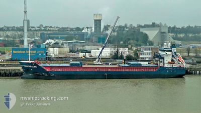
TERSCHELLING
General Cargo
Current Trip
| Time Travelled | 3 days |
|---|---|
| Remaining Time | 13 h, 14 mins |
| Distance Travelled | 705.25 nm |
| Remaining Distance | 130.94 nm |
| AVG Speed | 8.5 Noeuds |
| MAX Speed | 11.9 Noeuds |
| AVG Wind | 10.5 knots |
| MAX Wind | 23.9 knots |
| MIN Temp | 7.7°C / 45.86°F |
| MAX Temp | 15.1°C / 59.18°F |
| Tirant d eau | 6.8 m |
| Position reçue | Maintenant |
Current Position
| Longitude | 19.33108° |
|---|---|
| Latitude | 60.06061° |
| Etat | Under way using engine |
| Vitesse | 10.1 Noeuds |
| Parcours | 321.4° |
| Zone | Gulf of Bothnia |
| Station | T-AIS |
| Position reçue | Maintenant |
Info
Information
The current position of TERSCHELLING is in Gulf of Bothnia with coordinates 60.06061° / 19.33108° as reported on 2024-06-09 03:55 by AIS to our vessel tracker app. The vessel's current speed is 10.1 Noeuds and is heading at the port of MANTYLUOTO. The estimated time of arrival as calculated by MyShipTracking vessel tracking app is 2024-06-09 20:10 LT
The vessel TERSCHELLING (IMO: 9313826, MMSI: 246507000) is a General Cargo that was built in 2005 ( 19 Age ). It's sailing under the flag of [NL] Netherlands.
In this page you can find informations about the vessels current position, last detected port calls, and current voyage information. If the vessels is not in coverage by AIS you will find the latest position.
The current position of TERSCHELLING is detected by our AIS receivers and we are not responsible for the reliability of the data. The last position was recorded while the vessel was in Coverage by the Ais receivers of our vessel tracking app.
The current draught of TERSCHELLING as reported by AIS is 6.8 meters
Weather
| Temperature | 10.1°C / 50.18°F |
|---|---|
| Wind Speed | 19 knots |
| Direction | 130° SE |
| Pressure | 993.8 hPa |
| Humidity | 96.8 % |
| Cloud Coverage | 100 % |
Featured Company
Last Port Calls
| Port | Arrival | Departure | Time In Port |
|---|---|---|---|
| 2024-06-01 14:38 | 2024-06-05 19:38 | 4 d | |
| 2024-05-29 08:21 | 2024-05-31 16:21 | 2 d | |
| 2024-05-23 10:56 | 2024-05-27 23:31 | 4 d | |
| 2024-05-20 23:25 | 2024-05-23 09:14 | 2 d | |
| 2024-05-09 13:32 | 2024-05-15 11:16 | 5 d | |
| 2024-05-02 11:49 | 2024-05-03 16:09 | 1 d | |
| 2024-04-28 05:24 | 2024-04-28 12:54 | 7 h | |
| 2024-04-27 13:16 | 2024-04-27 22:45 | 9 h | |
| 2024-04-26 09:43 | 2024-04-27 04:57 | 19 h | |
| 2024-04-24 15:18 | 2024-04-24 22:29 | 7 h |
Last Trips
| Origin | Departure | Destination | Arrival | Distance | |
|---|---|---|---|---|---|
| 2024-05-31 16:21 | 2024-06-01 14:38 | 258.78 nm | |||
| 2024-05-27 23:31 | 2024-05-29 08:21 | 364.89 nm | |||
| 2024-05-23 09:14 | 2024-05-23 10:56 | 17.04 nm | |||
| 2024-05-15 11:16 | 2024-05-20 23:25 | 860.22 nm | |||
| 2024-05-03 16:09 | 2024-05-09 13:32 | 1408.92 nm | |||
| 2024-04-28 12:54 | 2024-05-02 11:49 | 962.11 nm | |||
| 2024-04-27 22:45 | 2024-04-28 05:24 | 75.97 nm | |||
| 2024-04-27 04:57 | 2024-04-27 13:16 | 89.16 nm | |||
| 2024-04-24 22:29 | 2024-04-26 09:43 | 308.47 nm | |||
| 2024-04-24 06:35 | 2024-04-24 15:18 | 92.07 nm |
Events
| Heure | Evenement | Détails | Position/ Destination | Info |
|---|---|---|---|---|
| 2024-06-09 01:43 | Changement de zone | Finnish part of the Gulf of Bothnia Finnish part of the Baltic Sea |
59.78058 / 19.79959
Gulf of Bothnia
MANTYLUOTO
|
Vitesse: 9.6 kn Parcours: 321.9° |
| 2024-06-09 00:47 | Etat Changé | Under way using engine Default |
59.66732 / 19.98983
MANTYLUOTO
|
Vitesse: 9.4 kn Parcours: 321° |
| 2024-06-09 00:33 | Etat Changé | Default Under way using engine |
59.64092 / 20.03275
MANTYLUOTO
|
Vitesse: 9.4 kn Parcours: 322° |
| 2024-06-09 00:25 | Detecté en mer | Finnish part of the Baltic Sea |
59.62368 / 20.06003
Baltic Sea
MANTYLUOTO
|
Vitesse: 9.4 kn Parcours: 319.9° |
| 2024-06-09 00:24 | Etat Changé | Under way using engine Default |
59.62235 / 20.06221
MANTYLUOTO
|
Vitesse: 9.5 kn Parcours: 322° |
| 2024-06-09 00:17 | Dans la zone couverte |
59.62368 / 20.06003
Baltic Sea
MANTYLUOTO
|
Vitesse: 9.4 kn Parcours: 319.9° |
|
| 2024-06-08 16:45 | Etat Changé | Default Under way using engine |
58.53966 / 19.04893
MANTYLUOTO
|
Vitesse: 9.6 kn Parcours: 30.6° |
| 2024-06-08 16:40 | Hors de la zone couverte |
58.52831 / 19.03639
Baltic Sea
MANTYLUOTO
|
Vitesse: 9.6 kn Parcours: 30.6° |
|
| 2024-06-08 16:25 | Etat Changé | Under way using engine Default |
58.49202 / 18.99632
MANTYLUOTO
|
Vitesse: 9.6 kn Parcours: 30° |
| 2024-06-08 16:05 | Etat Changé | Default Under way using engine |
58.44878 / 18.94809
MANTYLUOTO
|
Vitesse: 9.2 kn Parcours: 30.6° |