

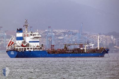
SYMI
Tanker

Current Trip
GIBRALTAR
| Time Travelled | 23 h, 22 mins |
|---|---|
| Remaining Time | --- |
| Distance Travelled | 11.06 nm |
| Remaining Distance | --- |
| AVG Speed | 6.9 Noeuds |
| MAX Speed | 9.7 Noeuds |
| AVG Wind | 3.6 knots |
| MAX Wind | 8.2 knots |
| MIN Temp | 11.5°C / 52.7°F |
| MAX Temp | 17.2°C / 62.96°F |
| Tirant d eau | 5.3 m |
| Position reçue | 1 m depuis |
Current Position
| Longitude | --- |
|---|---|
| Latitude | --- |
| Etat | At anchor |
| Vitesse | |
| Parcours | 142° |
| Zone | Alboran Sea |
| Station | T-AIS |
| Position reçue | 1 m depuis |
Information
The current position of SYMI is in Alboran Sea with coordinates 36.13634° / -5.30875° as reported on 2025-02-28 02:44 by AIS to our vessel tracker app. The vessel's current speed is 0 Noeuds
The vessel SYMI (IMO: 9418016, MMSI: 236717000) is a Tanker It's sailing under the flag of [GI] Gibraltar.
In this page you can find informations about the vessels current position, last detected port calls, and current voyage information. If the vessels is not in coverage by AIS you will find the latest position.
The current position of SYMI is detected by our AIS receivers and we are not responsible for the reliability of the data. The last position was recorded while the vessel was in Coverage by the Ais receivers of our vessel tracking app.
The current draught of SYMI as reported by AIS is 5.3 meters
Weather
| Temperature | 15.4°C / 59.72°F |
|---|---|
| Wind Speed | 8 knots |
| Direction | 90° E |
| Pressure | 1014.7 hPa |
| Humidity | 78.7 % |
| Cloud Coverage | 88 % |


Featured Company
Last Port Calls
| Port | Arrival | Departure | Time In Port |
|---|---|---|---|
| 2025-02-26 19:47 | 2025-02-27 04:23 | 8 h | |
| 2025-02-26 03:58 | 2025-02-26 10:58 | 7 h | |
| 2025-02-24 23:24 | 2025-02-25 11:16 | 11 h | |
| 2025-02-24 10:09 | 2025-02-24 17:27 | 7 h | |
| 2025-02-22 09:14 | 2025-02-22 09:40 | 26 m | |
| 2025-02-21 08:26 | 2025-02-21 18:07 | 9 h | |
| 2025-02-17 23:50 | 2025-02-18 13:11 | 13 h | |
| 2025-02-17 13:51 | 2025-02-17 22:03 | 8 h | |
| 2025-02-14 15:38 | 2025-02-15 01:02 | 9 h | |
| 2025-02-12 13:38 | 2025-02-13 17:58 | 1 d |
Most Visited Ports (Last year)
| Port | Arrivals | |
|---|---|---|
| 137 | ||
| 113 | ||
| 12 | ||
| 3 |
Last Trips
| Origin | Departure | Destination | Arrival | Distance | |
|---|---|---|---|---|---|
| 2025-02-26 10:58 | 2025-02-26 19:47 | 3.99 nm | |||
| 2025-02-25 11:16 | 2025-02-26 03:58 | 32.95 nm | |||
| 2025-02-24 17:27 | 2025-02-24 23:24 | 24.77 nm | |||
| 2025-02-22 09:40 | 2025-02-24 10:09 | 12.35 nm | |||
| 2025-02-21 18:07 | 2025-02-22 09:14 | 19.92 nm | |||
| 2025-02-18 13:11 | 2025-02-21 08:26 | 44.14 nm | |||
| 2025-02-17 22:03 | 2025-02-17 23:50 | 17.54 nm | |||
| 2025-02-15 01:02 | 2025-02-17 13:51 | 56.58 nm | |||
| 2025-02-13 17:58 | 2025-02-14 15:38 | 4.94 nm | |||
| 2025-02-12 13:13 | 2025-02-12 13:38 | 3.11 nm |
Events
| Heure | Evenement | Détails | Position/ Destination | Info |
|---|---|---|---|---|
| 2025-02-28 01:29 | Etat Changé | At anchor Default |
36.13586 / -5.30917
GIBRALTAR
|
Vitesse: 0.1 kn Parcours: 111° |
| 2025-02-28 01:26 | Etat Changé | Default At anchor |
36.13581 / -5.30921
GIBRALTAR
|
Vitesse: 0.1 kn Parcours: 108° |
| 2025-02-28 01:17 | Etat Changé | At anchor Default |
36.13570 / -5.30941
GIBRALTAR
|
Vitesse: 0.1 kn Parcours: 94° |
| 2025-02-28 01:14 | Etat Changé | Default At anchor |
36.13559 / -5.30934
GIBRALTAR
|
Vitesse: 0.2 kn Parcours: 94° |
| 2025-02-28 00:35 | Etat Changé | At anchor Default |
36.13496 / -5.30876
GIBRALTAR
|
Vitesse: Parcours: 70° |
| 2025-02-28 00:26 | Etat Changé | Default At anchor |
36.13495 / -5.30870
GIBRALTAR
|
Vitesse: Parcours: 67° |
| 2025-02-27 23:41 | Etat Changé | At anchor Default |
36.13475 / -5.30801
GIBRALTAR
|
Vitesse: 0.1 kn Parcours: 319° |
| 2025-02-27 23:38 | Etat Changé | Default At anchor |
36.13467 / -5.30800
GIBRALTAR
|
Vitesse: Parcours: 316° |
| 2025-02-27 22:41 | Etat Changé | At anchor Default |
36.13452 / -5.30842
GIBRALTAR
|
Vitesse: 0.2 kn Parcours: 345° |
| 2025-02-27 22:38 | Etat Changé | Default At anchor |
36.13456 / -5.30828
GIBRALTAR
|
Vitesse: 0.2 kn Parcours: 327° |