
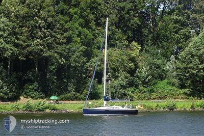
SY HUCKLEBERRY FINN
Sailing
Current Trip
| Trip Time | 7 days |
|---|---|
| Trip Distance | 108.03 nm |
| AVG Speed | 5.5 Noeuds |
| MAX Speed | 8.1 Noeuds |
| Tirant d eau | --- |
| AVG Wind | 9.5 knots |
| MAX Wind | 12.9 knots |
| MIN Temp | 13.9°C / 57.02°F |
| MAX Temp | 22.6°C / 72.68°F |
| Position reçue | 1 d depuis |
Current Position
| Longitude | 10.21638° |
|---|---|
| Latitude | 56.13845° |
| Etat | Default |
| Vitesse | 0.1 Noeuds |
| Parcours | 269° |
| Zone | Kattegat |
| Station | T-AIS |
| Position reçue | 1 d depuis |
Info
Information
The current position of SY HUCKLEBERRY FINN is in Kattegat with coordinates 56.13845° / 10.21638° as reported on 2024-06-01 13:30 by AIS to our vessel tracker app. The vessel's current speed is 0.1 Noeuds and is currently inside the port of AARHUS.
The vessel SY HUCKLEBERRY FINN (MMSI: 211103980) is a Sailing It's sailing under the flag of [DE] Germany.
In this page you can find informations about the vessels current position, last detected port calls, and current voyage information. If the vessels is not in coverage by AIS you will find the latest position.
The current position of SY HUCKLEBERRY FINN is detected by our AIS receivers and we are not responsible for the reliability of the data. The last position was recorded while the vessel was in Coverage by the Ais receivers of our vessel tracking app.
Weather
| Temperature | 22.9°C / 73.22°F |
|---|---|
| Wind Speed | 7 knots |
| Direction | 7° N |
| Pressure | 1015.2 hPa |
| Humidity | 61 % |
| Cloud Coverage | 52 % |
Featured Company
Last Port Calls
| Port | Arrival | Departure | Time In Port |
|---|---|---|---|
| 2024-06-01 12:15 | |||
| 2024-05-23 17:09 | 2024-05-25 09:53 | 1 d | |
| 2024-05-18 13:54 | 2024-05-23 11:29 | 4 d | |
| 2024-05-10 09:07 | 2024-05-18 10:42 | 8 d | |
| 2024-05-09 13:30 | 2024-05-10 09:00 | 19 h | |
| 2024-05-08 19:46 | 2024-05-09 11:24 | 15 h | |
| 2024-05-03 18:05 | 2024-05-08 07:47 | 4 d | |
| 2024-04-12 14:28 | 2024-05-02 06:44 | 19 d | |
| 2024-04-12 13:16 |
Last Trips
| Origin | Departure | Destination | Arrival | Distance | |
|---|---|---|---|---|---|
| 2024-05-25 11:53 | 2024-06-01 14:15 | 108.03 nm | |||
| 2024-05-23 13:29 | 2024-05-23 19:09 | 33.80 nm | |||
| 2024-05-18 12:42 | 2024-05-18 15:54 | 17.33 nm | |||
| 2024-05-10 11:00 | 2024-05-10 11:07 | 0.37 nm | |||
| 2024-05-09 13:24 | 2024-05-09 15:30 | 5.63 nm | |||
| 2024-05-08 09:47 | 2024-05-08 21:46 | 67.29 nm | |||
| 2024-05-02 08:44 | 2024-05-03 20:05 | 101.45 nm | |||
| 2024-04-12 15:16 | 2024-04-12 16:28 | 6.76 nm |
Events
| Heure | Evenement | Détails | Position/ Destination | Info |
|---|---|---|---|---|
| 2024-06-01 13:30 | Hors de la zone couverte |
56.13845 / 10.21638
Kattegat
[DK] AARHUS
|
Vitesse: 0.1 kn Parcours: 269° |
|
| 2024-06-01 12:27 | Arret |
56.13845 / 10.21642
[DK] AARHUS
|
Vitesse: 0.2 kn Parcours: 260° |
|
| 2024-06-01 12:15 | Port d'arrivée |
|
56.13550 / 10.22115
[DK] AARHUS
|
Vitesse: 6.8 kn Parcours: 287.1° |
| 2024-06-01 06:37 | Démarrage | 4.05 nm, East of KOLBY |
55.81768 / 10.64201
|
Vitesse: 3.2 kn Parcours: 77° |
| 2024-06-01 04:50 | Dans la zone couverte |
55.81575 / 10.64064
Kattegat
|
Vitesse: 0.1 kn Parcours: 68° |
|
| 2024-05-31 22:05 | Hors de la zone couverte |
55.81582 / 10.64059
Kattegat
|
Vitesse: 0.1 kn Parcours: 59° |
|
| 2024-05-31 19:20 | Dans la zone couverte |
55.81582 / 10.64057
Kattegat
|
Vitesse: Parcours: 60° |
|
| 2024-05-31 12:50 | Hors de la zone couverte |
55.81579 / 10.64065
Kattegat
|
Vitesse: 0.1 kn Parcours: 61° |
|
| 2024-05-31 07:56 | Arret | 3.97 nm, East of KOLBY |
55.81579 / 10.64063
|
Vitesse: 0.3 kn Parcours: 61° |
| 2024-05-31 07:53 | Dans la zone couverte |
55.81571 / 10.64080
Kattegat
|
Vitesse: 0.9 kn Parcours: 62° |