
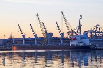
SUPER ARSENAL
Bulk Carrier
Current Trip
TR IST
| Time Travelled | 40 mins |
|---|---|
| Remaining Time | --- |
| Distance Travelled | 2.95 nm |
| Remaining Distance | --- |
| AVG Speed | 9.9 Noeuds |
| MAX Speed | 10.1 Noeuds |
| AVG Wind | 8.7 knots |
| MAX Wind | 8.8 knots |
| MIN Temp | 13.3°C / 55.94°F |
| MAX Temp | 13.3°C / 55.94°F |
| Tirant d eau | 9.9 m |
| Position reçue | Maintenant |
Current Position
| Longitude | 28.91929° |
|---|---|
| Latitude | 40.95080° |
| Etat | Under way using engine |
| Vitesse | 2.7 Noeuds |
| Parcours | 240° |
| Zone | Sea of Marmara |
| Station | T-AIS |
| Position reçue | Maintenant |
Info
Information
The current position of SUPER ARSENAL is in Sea of Marmara with coordinates 40.95080° / 28.91929° as reported on 2024-05-16 20:21 by AIS to our vessel tracker app. The vessel's current speed is 2.7 Noeuds
The vessel SUPER ARSENAL (IMO: 9316933, MMSI: 376568000) is a Bulk Carrier that was built in 2005 ( 19 Age ). It's sailing under the flag of [VC] St Vincent Grenadines.
In this page you can find informations about the vessels current position, last detected port calls, and current voyage information. If the vessels is not in coverage by AIS you will find the latest position.
The current position of SUPER ARSENAL is detected by our AIS receivers and we are not responsible for the reliability of the data. The last position was recorded while the vessel was in Coverage by the Ais receivers of our vessel tracking app.
The current draught of SUPER ARSENAL as reported by AIS is 9.9 meters
Weather
| Temperature | 13.2°C / 55.76°F |
|---|---|
| Wind Speed | 9 knots |
| Direction | 72° ENE |
| Pressure | 1021.1 hPa |
| Humidity | 59.3 % |
| Cloud Coverage | 89 % |
Featured Company
Last Port Calls
| Port | Arrival | Departure | Time In Port |
|---|---|---|---|
| 2024-05-16 18:28 | 2024-05-16 19:41 | 1 h | |
| 2024-05-08 07:55 | 2024-05-14 04:49 | 5 d | |
| 2024-04-28 00:28 | 2024-05-02 20:27 | 4 d | |
| 2024-04-24 11:16 | 2024-04-24 16:31 | 5 h | |
| 2024-04-20 01:16 | 2024-04-20 02:31 | 1 h | |
| 2024-04-14 07:42 | 2024-04-17 04:31 | 2 d | |
| 2024-03-24 01:38 | 2024-04-02 12:10 | 9 d |
Last Trips
| Origin | Departure | Destination | Arrival | Distance | |
|---|---|---|---|---|---|
| 2024-05-14 07:49 | 2024-05-16 21:28 | 342.29 nm | |||
| 2024-05-02 22:27 | 2024-05-08 10:55 | 1170.51 nm | |||
| 2024-04-24 18:31 | 2024-04-28 02:28 | 28.50 nm | |||
| 2024-04-20 05:31 | 2024-04-24 13:16 | 782.85 nm | |||
| 2024-04-17 07:31 | 2024-04-20 04:16 | 347.07 nm | |||
| 2024-04-02 13:10 | 2024-04-14 10:42 | 2127.86 nm | |||
| 2024-02-29 01:57 | 2024-03-24 02:38 | 1671.74 nm |
Events
| Heure | Evenement | Détails | Position/ Destination | Info |
|---|---|---|---|---|
| 2024-05-16 19:41 | PORT DE DEPART |
|
41.00221 / 28.99469
TR IST
|
Vitesse: 11.2 kn Parcours: 190° |
| 2024-05-16 18:28 | Port d'arrivée |
|
41.20327 / 29.11130
[TR] ISTANBUL
|
Vitesse: 9.8 kn Parcours: 212.7° |
| 2024-05-16 18:17 | Changement de zone | Turkish part of the Sea of Marmara Turkish part of the Black Sea |
41.23199 / 29.12416
Sea of Marmara
|
Vitesse: 9.4 kn Parcours: 166.8° |
| 2024-05-16 17:33 | Démarrage | 4.42 nm, North West of RUMELI FENERI |
41.28104 / 29.04086
TR IST
|
Vitesse: 4.1 kn Parcours: 95° |
| 2024-05-16 17:12 | Etat Changé | Under way using engine At anchor |
41.28170 / 29.03458
TR IST
|
Vitesse: Parcours: 94° |
| 2024-05-16 17:07 | Etat Changé | At anchor Default |
41.28170 / 29.03458
TR IST
|
Vitesse: Parcours: 94° |
| 2024-05-16 16:25 | Etat Changé | Default At anchor |
41.28163 / 29.03455
TR IST
|
Vitesse: Parcours: 93° |
| 2024-05-16 14:02 | Etat Changé | At anchor Default |
41.28174 / 29.03474
TR IST
|
Vitesse: Parcours: -1° |
| 2024-05-16 14:00 | Etat Changé | Default At anchor |
41.28167 / 29.03333
TR IST
|
Vitesse: 0.1 kn Parcours: 90° |
| 2024-05-16 12:49 | Etat Changé | At anchor Default |
41.28167 / 29.03461
TR IST
|
Vitesse: Parcours: -1° |