
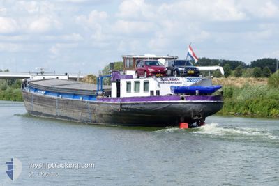
SUBURBAN
Cargo
Current Trip
| Time Travelled | 6 days |
|---|---|
| Remaining Time | --- |
| Distance Travelled | 234.24 nm |
| Remaining Distance | --- |
| AVG Speed | 7.8 Noeuds |
| MAX Speed | 11.7 Noeuds |
| AVG Wind | 5.2 knots |
| MAX Wind | 10 knots |
| MIN Temp | 7.4°C / 45.32°F |
| MAX Temp | 22.6°C / 72.68°F |
| Tirant d eau | 0 m |
| Position reçue | 6 m depuis |
Current Position
| Longitude | 5.98745° |
|---|---|
| Latitude | 51.63885° |
| Etat | Moored |
| Vitesse | |
| Parcours | --- |
| Zone | North Sea |
| Station | T-AIS |
| Position reçue | 6 m depuis |
Info
Information
The current position of SUBURBAN is in North Sea with coordinates 51.63885° / 5.98745° as reported on 2024-05-13 23:46 by AIS to our vessel tracker app. The vessel's current speed is 0 Noeuds and is heading at the port of STEIN. The estimated time of arrival as calculated by MyShipTracking vessel tracking app is 2024-05-14 14:52 LT
The vessel SUBURBAN (MMSI: 244660778) is a Cargo It's sailing under the flag of [NL] Netherlands.
In this page you can find informations about the vessels current position, last detected port calls, and current voyage information. If the vessels is not in coverage by AIS you will find the latest position.
The current position of SUBURBAN is detected by our AIS receivers and we are not responsible for the reliability of the data. The last position was recorded while the vessel was in Coverage by the Ais receivers of our vessel tracking app.
Weather
| Temperature | 15.6°C / 60.08°F |
|---|---|
| Wind Speed | 6 knots |
| Direction | 150° SSE |
| Pressure | 1007.9 hPa |
| Humidity | 89.9 % |
| Cloud Coverage | 9 % |
Featured Company
Last Port Calls
| Port | Arrival | Departure | Time In Port |
|---|---|---|---|
| 2024-05-07 16:59 | 2024-05-07 18:17 | 1 h | |
| 2024-05-07 04:41 | 2024-05-07 13:21 | 8 h | |
| 2024-05-01 05:28 | 2024-05-01 05:41 | 13 m | |
| 2024-04-30 18:21 | 2024-05-01 04:10 | 9 h | |
| 2024-04-30 16:58 | 2024-04-30 17:41 | 43 m | |
| 2024-04-23 15:24 | 2024-04-30 14:45 | 6 d | |
| 2024-04-21 15:33 | 2024-04-23 05:24 | 1 d | |
| 2024-04-18 22:29 | 2024-04-21 08:29 | 2 d | |
| 2024-04-11 11:30 | 2024-04-11 11:55 | 25 m | |
| 2024-04-10 11:08 | 2024-04-10 13:08 | 1 h |
Most Visited Ports (Last year)
| Port | Arrivals | |
|---|---|---|
| 32 | ||
| 26 | ||
| 10 | ||
| 9 | ||
| 8 | ||
| 7 |
Last Trips
| Origin | Departure | Destination | Arrival | Distance | |
|---|---|---|---|---|---|
| 2024-05-07 15:21 | 2024-05-07 18:59 | 29.84 nm | |||
| 2024-05-01 07:41 | 2024-05-07 06:41 | 200.28 nm | |||
| 2024-05-01 06:10 | 2024-05-01 07:28 | 9.83 nm | |||
| 2024-04-30 19:41 | 2024-04-30 20:21 | 3.77 nm | |||
| 2024-04-30 16:45 | 2024-04-30 18:58 | 19.85 nm | |||
| 2024-04-23 07:24 | 2024-04-23 17:24 | 62.15 nm | |||
| 2024-04-21 10:29 | 2024-04-21 17:33 | 46.11 nm | |||
| 2024-04-11 13:55 | 2024-04-19 00:29 | 134.66 nm | |||
| 2024-04-10 15:08 | 2024-04-11 13:30 | 55.09 nm | |||
| 2024-04-10 07:34 | 2024-04-10 13:08 | 38.75 nm |
Events
| Heure | Evenement | Détails | Position/ Destination | Info |
|---|---|---|---|---|
| 2024-05-13 20:08 | Etat Changé | Moored Under way using engine |
51.63884 / 5.98744
STEIN
|
Vitesse: Parcours: 511° |
| 2024-05-13 19:48 | Arret | 2.13 nm, South East of BOXMEER |
51.63884 / 5.98733
STEIN
|
Vitesse: 0.1 kn Parcours: 511° |
| 2024-05-13 19:45 | Démarrage | 2.01 nm, South East of BOXMEER |
51.64012 / 5.98469
STEIN
|
Vitesse: 4.5 kn Parcours: 121.3° |
| 2024-05-13 19:36 | Arret | 1.9 nm, South East of BOXMEER |
51.64114 / 5.98182
STEIN
|
Vitesse: Parcours: 511° |
| 2024-05-13 17:30 | Démarrage | 0.31 nm, North of NIJMEGEN |
51.85214 / 5.82149
STEIN
|
Vitesse: 6.4 kn Parcours: 210° |
| 2024-05-13 17:22 | Arret | 0.41 nm, North of NIJMEGEN |
51.85390 / 5.82301
STEIN
|
Vitesse: Parcours: 511° |
| 2024-05-13 15:05 | Démarrage | 0.9 nm, North East of TIEL |
51.90006 / 5.45470
STEIN
|
Vitesse: 4 kn Parcours: 157.3° |
| 2024-05-13 14:50 | Arret | 0.98 nm, North East of TIEL |
51.90198 / 5.45346
STEIN
|
Vitesse: Parcours: 511° |
| 2024-05-13 12:44 | Démarrage | 1.45 nm, East of VIANEN |
51.99051 / 5.13677
STEIN
|
Vitesse: 6.8 kn Parcours: 145.1° |
| 2024-05-13 12:28 | Arret | 1.37 nm, East of VIANEN |
51.99233 / 5.13456
STEIN
|
Vitesse: Parcours: 511° |