

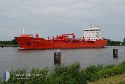
STEN NORDIC
Oil/Chemical Tanker

Current Trip
| Time Travelled | 1 day |
|---|---|
| Remaining Time | 21 h, 7 mins |
| Distance Travelled | 318.20 nm |
| Remaining Distance | 331.71 nm |
| AVG Speed | 11.2 Noeuds |
| MAX Speed | 14.6 Noeuds |
| AVG Wind | 9.9 knots |
| MAX Wind | 16.9 knots |
| MIN Temp | -2.7°C / 27.14°F |
| MAX Temp | 3.3°C / 37.94°F |
| Tirant d eau | 8.3 m |
| Position reçue | 2 h, 30 m depuis |
Current Position
| Longitude | --- |
|---|---|
| Latitude | --- |
| Etat | Under way using engine |
| Vitesse | 11.8 Noeuds |
| Parcours | 214.3° |
| Zone | North Sea |
| Station | T-AIS |
| Position reçue | 2 h, 30 m depuis |
Information
The current position of STEN NORDIC is in North Sea with coordinates 56.95182° / 7.47903° as reported on 2025-02-17 15:22 by AIS to our vessel tracker app. The vessel's current speed is 11.8 Noeuds and is heading at the port of AMSTERDAM. The estimated time of arrival as calculated by MyShipTracking vessel tracking app is 2025-02-18 15:00 LT
The vessel STEN NORDIC (IMO: 9351567, MMSI: 257667000) is a Oil/Chemical Tanker that was built in 2005 ( 20 Age ). It's sailing under the flag of [NO] Norway.
In this page you can find informations about the vessels current position, last detected port calls, and current voyage information. If the vessels is not in coverage by AIS you will find the latest position.
The current position of STEN NORDIC is detected by our AIS receivers and we are not responsible for the reliability of the data. The last position was recorded while the vessel was in Coverage by the Ais receivers of our vessel tracking app.
The current draught of STEN NORDIC as reported by AIS is 8.3 meters
Weather
| Temperature | 1.4°C / 34.52°F |
|---|---|
| Wind Speed | 10 knots |
| Direction | 276° W |
| Pressure | 1026.4 hPa |
| Humidity | 66.2 % |
| Cloud Coverage | 96 % |


Featured Company
Last Port Calls
| Port | Arrival | Departure | Time In Port |
|---|---|---|---|
| 2025-02-14 22:25 | 2025-02-16 12:09 | 1 d | |
| 2025-02-12 20:01 | 2025-02-14 05:06 | 1 d | |
| 2025-02-09 00:39 | 2025-02-10 03:31 | 1 d | |
| 2025-02-05 20:53 | 2025-02-06 19:14 | 22 h | |
| 2025-02-02 05:05 | 2025-02-03 20:25 | 1 d | |
| 2025-01-27 14:04 | 2025-01-30 14:29 | 3 d | |
| 2025-01-22 22:49 | 2025-01-24 04:54 | 1 d | |
| 2025-01-19 00:49 | 2025-01-20 08:41 | 1 d | |
| 2025-01-15 20:42 | 2025-01-17 03:18 | 1 d | |
| 2025-01-12 10:34 | 2025-01-14 14:47 | 2 d |
Last Trips
| Origin | Departure | Destination | Arrival | Distance | |
|---|---|---|---|---|---|
| 2025-02-14 06:06 | 2025-02-14 23:25 | 202.73 nm | |||
| 2025-02-10 04:31 | 2025-02-12 21:01 | 432.55 nm | |||
| 2025-02-06 20:14 | 2025-02-09 01:39 | 446.01 nm | |||
| 2025-02-03 21:25 | 2025-02-05 21:53 | 585.35 nm | |||
| 2025-01-30 15:29 | 2025-02-02 06:05 | 98.97 nm | |||
| 2025-01-24 05:54 | 2025-01-27 15:04 | 742.82 nm | |||
| 2025-01-20 10:41 | 2025-01-22 23:49 | 477.34 nm | |||
| 2025-01-17 04:18 | 2025-01-19 02:49 | 493.52 nm | |||
| 2025-01-14 15:47 | 2025-01-15 21:42 | 145.43 nm | |||
| 2025-01-10 12:56 | 2025-01-12 11:34 | 525.02 nm |
Events
| Heure | Evenement | Détails | Position/ Destination | Info |
|---|---|---|---|---|
| 2025-02-17 15:41 | Etat Changé | Default Under way using engine |
56.90297 / 7.40819
NLAMS
|
Vitesse: 11.8 kn Parcours: 214.3° |
| 2025-02-17 15:22 | Etat Changé | Under way using engine Default |
56.95182 / 7.47903
NLAMS
|
Vitesse: 11.6 kn Parcours: 206° |
| 2025-02-17 15:22 | Hors de la zone couverte |
56.95182 / 7.47903
North Sea
NLAMS
|
Vitesse: 11.8 kn Parcours: 214.3° |
|
| 2025-02-17 14:29 | Etat Changé | Default Under way using engine |
57.10538 / 7.61317
NLAMS
|
Vitesse: 9 kn Parcours: 225.3° |
| 2025-02-17 12:34 | Changement de zone | Danish part of the North Sea Danish part of the Skaggerak |
57.36052 / 8.16547
North Sea
NLAMS
|
Vitesse: 11.5 kn Parcours: 239.6° |
| 2025-02-17 03:53 | Detecté en mer | Danish part of the Skaggerak |
57.80243 / 10.94780
Skaggerak
NLAMS
|
Vitesse: 11.2 kn Parcours: 310.2° |
| 2025-02-17 02:50 | Detecté en mer | Danish part of the Kattegat |
57.65126 / 11.20094
Kattegat
NLAMS
|
Vitesse: 11.6 kn Parcours: 320° |
| 2025-02-16 22:44 | Changement de zone | Swedish part of the Kattegat Danish part of the Kattegat |
56.94108 / 11.80606
Kattegat
NLAMS
|
Vitesse: 11.3 kn Parcours: 346.8° |
| 2025-02-16 15:10 | Changement d'ETA | 2025/02/19 00:01 2025/02/19 06:00 |
55.69817 / 10.74143
NLAMS
|
Vitesse: 12.3 kn Parcours: 42.8° |
| 2025-02-16 12:36 | Changement d'ETA | 2025/02/19 06:00 2025/02/16 18:00 |
55.58289 / 9.88202
NLAMS
|
Vitesse: 6.7 kn Parcours: 144.3° |