
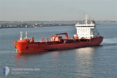
STEN MOSTER
Oil/Chemical Tanker
Current Trip
| Time Travelled | 7 days |
|---|---|
| Remaining Time | --- |
| Distance Travelled | 652.80 nm |
| Remaining Distance | 84.77 nm |
| AVG Speed | 10.7 Noeuds |
| MAX Speed | 13.7 Noeuds |
| AVG Wind | 17.4 knots |
| MAX Wind | 30 knots |
| MIN Temp | -0.2°C / 31.64°F |
| MAX Temp | 9°C / 48.2°F |
| Tirant d eau | 8.2 m |
| Position reçue | 1 m depuis |
Current Position
| Longitude | --- |
|---|---|
| Latitude | --- |
| Etat | At anchor |
| Vitesse | |
| Parcours | 214° |
| Zone | North Sea |
| Station | T-AIS |
| Position reçue | 1 m depuis |
Info
Information
The current position of STEN MOSTER is in North Sea with coordinates 51.81327° / 3.35818° as reported on 2025-01-18 03:26 by AIS to our vessel tracker app. The vessel's current speed is 0 Noeuds and is heading at the port of ANTWERP. The estimated time of arrival as calculated by MyShipTracking vessel tracking app is 2025-01-13 06:30 LT
The vessel STEN MOSTER (IMO: 9341184, MMSI: 257840000) is a Oil/Chemical Tanker that was built in 2006 ( 19 Age ). It's sailing under the flag of [NO] Norway.
In this page you can find informations about the vessels current position, last detected port calls, and current voyage information. If the vessels is not in coverage by AIS you will find the latest position.
The current position of STEN MOSTER is detected by our AIS receivers and we are not responsible for the reliability of the data. The last position was recorded while the vessel was in Coverage by the Ais receivers of our vessel tracking app.
The current draught of STEN MOSTER as reported by AIS is 8.2 meters
Weather
| Temperature | 2.8°C / 37.04°F |
|---|---|
| Wind Speed | 4 knots |
| Direction | 125° SE |
| Pressure | 1032.8 hPa |
| Humidity | 86.3 % |
| Cloud Coverage | 100 % |
Featured Company
Last Port Calls
| Port | Arrival | Departure | Time In Port |
|---|---|---|---|
| 2025-01-09 10:30 | 2025-01-10 19:29 | 1 d | |
| 2025-01-05 07:01 | 2025-01-06 09:56 | 1 d | |
| 2025-01-02 02:26 | 2025-01-03 07:34 | 1 d | |
| 2024-12-29 06:18 | 2024-12-30 09:24 | 1 d | |
| 2024-12-25 22:24 | 2024-12-27 05:23 | 1 d | |
| 2024-12-20 17:59 | 2024-12-21 20:14 | 1 d | |
| 2024-12-13 12:20 | 2024-12-16 12:40 | 3 d | |
| 2024-12-10 22:01 | 2024-12-12 00:54 | 1 d | |
| 2024-11-30 21:54 | 2024-12-01 21:15 | 23 h | |
| 2024-11-26 18:32 | 2024-11-28 06:23 | 1 d |
Most Visited Ports (Last year)
| Port | Arrivals | |
|---|---|---|
| 9 | ||
| 7 | ||
| 6 | ||
| 5 | ||
| 4 | ||
| 4 |
Last Trips
| Origin | Departure | Destination | Arrival | Distance | |
|---|---|---|---|---|---|
| 2025-01-06 10:56 | 2025-01-09 11:30 | 307.25 nm | |||
| 2025-01-03 08:34 | 2025-01-05 08:01 | 542.76 nm | |||
| 2024-12-30 10:24 | 2025-01-02 03:26 | 571.95 nm | |||
| 2024-12-27 06:23 | 2024-12-29 07:18 | 544.13 nm | |||
| 2024-12-21 20:14 | 2024-12-25 23:24 | 686.57 nm | |||
| 2024-12-16 13:40 | 2024-12-20 17:59 | 651.37 nm | |||
| 2024-12-12 01:54 | 2024-12-13 13:20 | 417.96 nm | |||
| 2024-12-01 22:15 | 2024-12-10 23:01 | 1839.47 nm | |||
| 2024-11-28 07:23 | 2024-11-30 22:54 | 610.29 nm | |||
| 2024-11-23 12:32 | 2024-11-26 19:32 | 606.43 nm |
Events
| Heure | Evenement | Détails | Position/ Destination | Info |
|---|---|---|---|---|
| 2025-01-18 02:32 | Etat Changé | At anchor Default |
51.81168 / 3.35712
BEANR
|
Vitesse: 0.1 kn Parcours: 7° |
| 2025-01-18 02:26 | Etat Changé | Default At anchor |
51.81164 / 3.35654
BEANR
|
Vitesse: 0.1 kn Parcours: 16° |
| 2025-01-18 02:02 | Etat Changé | At anchor Default |
51.81171 / 3.35563
BEANR
|
Vitesse: Parcours: 45° |
| 2025-01-18 01:59 | Etat Changé | Default At anchor |
51.81171 / 3.35567
BEANR
|
Vitesse: Parcours: 43° |
| 2025-01-18 01:41 | Etat Changé | At anchor Default |
51.81153 / 3.35553
BEANR
|
Vitesse: Parcours: 43° |
| 2025-01-18 01:35 | Etat Changé | Default At anchor |
51.81150 / 3.35551
BEANR
|
Vitesse: Parcours: 40° |
| 2025-01-17 23:14 | Etat Changé | At anchor Default |
51.81143 / 3.35520
BEANR
|
Vitesse: Parcours: 45° |
| 2025-01-17 23:03 | Etat Changé | Default At anchor |
51.81147 / 3.35520
BEANR
|
Vitesse: Parcours: 48° |
| 2025-01-17 19:20 | Etat Changé | At anchor Default |
51.81391 / 3.35640
BEANR
|
Vitesse: Parcours: 161° |
| 2025-01-17 19:17 | Etat Changé | Default At anchor |
51.81393 / 3.35645
BEANR
|
Vitesse: Parcours: 161° |