
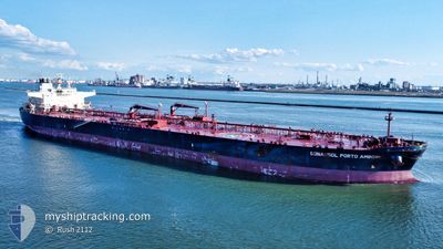
SONANGOL PORTOAMBOI
Crude Oil Tanker
Current Trip
PAL USA
| Time Travelled | 41 days |
|---|---|
| Remaining Time | --- |
| Distance Travelled | 7787.10 nm |
| Remaining Distance | --- |
| AVG Speed | 11.4 Noeuds |
| MAX Speed | 14.4 Noeuds |
| AVG Wind | 9.3 knots |
| MAX Wind | 25.3 knots |
| MIN Temp | 7.8°C / 46.04°F |
| MAX Temp | 30.2°C / 86.36°F |
| Tirant d eau | 13 m |
| Position reçue | 1 h, 46 m depuis |
Current Position
| Longitude | -118.93465° |
|---|---|
| Latitude | 32.17120° |
| Etat | Under way using engine |
| Vitesse | 0.5 Noeuds |
| Parcours | 24° |
| Zone | North Pacific Ocean |
| Station | T-AIS |
| Position reçue | 1 h, 46 m depuis |
Info
Information
The current position of SONANGOL PORTOAMBOI is in North Pacific Ocean with coordinates 32.17120° / -118.93465° as reported on 2024-05-09 07:45 by AIS to our vessel tracker app. The vessel's current speed is 0.5 Noeuds
The vessel SONANGOL PORTOAMBOI (IMO: 9575577, MMSI: 311066300) is a Crude Oil Tanker that was built in 2012 ( 12 Age ). It's sailing under the flag of [BS] Bahamas.
In this page you can find informations about the vessels current position, last detected port calls, and current voyage information. If the vessels is not in coverage by AIS you will find the latest position.
The current position of SONANGOL PORTOAMBOI is detected by our AIS receivers and we are not responsible for the reliability of the data. The last position was recorded while the vessel was in Coverage by the Ais receivers of our vessel tracking app.
The current draught of SONANGOL PORTOAMBOI as reported by AIS is 13 meters
Weather
| Temperature | 14.1°C / 57.38°F |
|---|---|
| Wind Speed | 7 knots |
| Direction | 312° NW |
| Pressure | 1011.9 hPa |
| Humidity | 85.7 % |
| Cloud Coverage | --- |
Featured Company
Last Port Calls
| Port | Arrival | Departure | Time In Port |
|---|---|---|---|
| 2024-03-27 12:17 | 2024-03-28 09:34 | 21 h | |
| 2024-03-21 14:26 | 2024-03-22 21:39 | 1 d |
Most Visited Ports (Last year)
| Port | Arrivals | |
|---|---|---|
| 2 | ||
| 1 | ||
| 1 | ||
| 1 | ||
| 1 | ||
| 1 |
Last Trips
| Origin | Departure | Destination | Arrival | Distance | |
|---|---|---|---|---|---|
| 2024-03-22 14:39 | 2024-03-27 05:17 | 44.03 nm | |||
| 2024-02-23 05:37 | 2024-03-21 07:26 | 1898.53 nm |
Events
| Heure | Evenement | Détails | Position/ Destination | Info |
|---|---|---|---|---|
| 2024-05-09 07:49 | Etat Changé | Default Under way using engine |
32.17135 / -118.93332
PAL USA
|
Vitesse: 0.5 kn Parcours: 24° |
| 2024-05-09 07:45 | Hors de la zone couverte |
32.17120 / -118.93465
North Pacific Ocean
|
Vitesse: 0.5 kn Parcours: 57.4° |
|
| 2024-05-09 07:32 | Etat Changé | Under way using engine Default |
32.17120 / -118.93888
PAL USA
|
Vitesse: 1 kn Parcours: 31° |
| 2024-05-09 07:00 | Etat Changé | Default Under way using engine |
32.17210 / -118.95003
PAL USA
|
Vitesse: 1.6 kn Parcours: 25° |
| 2024-05-09 06:45 | Etat Changé | Under way using engine Default |
32.17270 / -118.95541
PAL USA
|
Vitesse: 0.6 kn Parcours: 21° |
| 2024-05-09 06:27 | Etat Changé | Default Under way using engine |
32.17357 / -118.96183
PAL USA
|
Vitesse: 1 kn Parcours: 27° |
| 2024-05-09 06:12 | Etat Changé | Under way using engine Default |
32.17389 / -118.96747
PAL USA
|
Vitesse: 1.8 kn Parcours: 22° |
| 2024-05-09 05:55 | Etat Changé | Default Under way using engine |
32.17408 / -118.97369
PAL USA
|
Vitesse: 1 kn Parcours: 27° |
| 2024-05-09 04:46 | Etat Changé | Under way using engine Default |
32.17387 / -119.00391
PAL USA
|
Vitesse: 1.9 kn Parcours: 22° |
| 2024-05-09 04:06 | Etat Changé | Default Under way using engine |
32.17353 / -119.02156
PAL USA
|
Vitesse: 2.3 kn Parcours: 23° |