
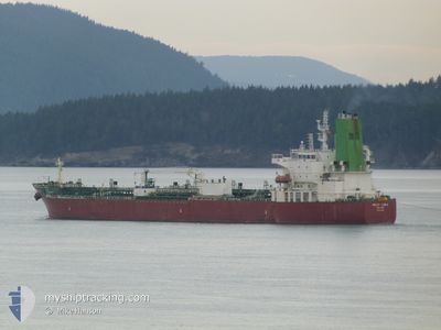
SILVER CARLA
Tanker
Current Trip
| Time Travelled | 2 days |
|---|---|
| Remaining Time | --- |
| Distance Travelled | 151.90 nm |
| Remaining Distance | --- |
| AVG Speed | 8.8 Noeuds |
| MAX Speed | 10.2 Noeuds |
| AVG Wind | 19.8 knots |
| MAX Wind | 26 knots |
| MIN Temp | 13.8°C / 56.84°F |
| MAX Temp | 18.9°C / 66.02°F |
| Tirant d eau | 11.4 m |
| Position reçue | 13 h, 25 m depuis |
Current Position
| Longitude | 129.57475° |
|---|---|
| Latitude | 35.05017° |
| Etat | Under way using engine |
| Vitesse | 9.8 Noeuds |
| Parcours | 52° |
| Zone | Japan Sea |
| Station | T-AIS |
| Position reçue | 13 h, 25 m depuis |
Info
Information
The current position of SILVER CARLA is in Japan Sea with coordinates 35.05017° / 129.57475° as reported on 2024-05-07 23:51 by AIS to our vessel tracker app. The vessel's current speed is 9.8 Noeuds and is heading at the port of LOS ANGELES. The estimated time of arrival as calculated by MyShipTracking vessel tracking app is 2024-05-27 12:00 LT
The vessel SILVER CARLA (IMO: 9682382, MMSI: 538005837) is a Tanker It's sailing under the flag of [MH] Marshall Is.
In this page you can find informations about the vessels current position, last detected port calls, and current voyage information. If the vessels is not in coverage by AIS you will find the latest position.
The current position of SILVER CARLA is detected by our AIS receivers and we are not responsible for the reliability of the data. The last position was recorded while the vessel was in Coverage by the Ais receivers of our vessel tracking app.
The current draught of SILVER CARLA as reported by AIS is 11.4 meters
Weather
| Temperature | 13.7°C / 56.66°F |
|---|---|
| Wind Speed | 20 knots |
| Direction | 27° NNE |
| Pressure | 1017.6 hPa |
| Humidity | 65.9 % |
| Cloud Coverage | 98 % |
Featured Company
Last Port Calls
| Port | Arrival | Departure | Time In Port |
|---|---|---|---|
| 2024-05-03 04:42 | 2024-05-06 04:32 | 2 d | |
| 2024-05-01 09:13 | 2024-05-01 23:22 | 14 h | |
| 2024-04-28 22:14 | 2024-04-29 22:04 | 23 h | |
| 2024-04-23 13:52 | 2024-04-24 06:43 | 16 h | |
| 2024-04-21 00:02 | 2024-04-21 20:33 | 20 h | |
| 2024-03-31 07:00 | 2024-04-01 21:03 | 1 d | |
| 2024-03-29 14:51 | 2024-03-31 06:19 | 1 d | |
| 2024-03-14 18:28 | 2024-03-16 07:24 | 1 d | |
| 2024-03-06 18:05 | 2024-03-08 02:07 | 1 d |
Most Visited Ports (Last year)
| Port | Arrivals | |
|---|---|---|
| 8 | ||
| 7 | ||
| 7 | ||
| 6 | ||
| 3 | ||
| 3 |
Last Trips
| Origin | Departure | Destination | Arrival | Distance | |
|---|---|---|---|---|---|
| 2024-05-02 08:22 | 2024-05-03 13:42 | 144.06 nm | |||
| 2024-04-30 07:04 | 2024-05-01 18:13 | 43.37 nm | |||
| 2024-04-24 14:43 | 2024-04-29 07:14 | 943.79 nm | |||
| 2024-04-22 04:33 | 2024-04-23 21:52 | 92.74 nm | |||
| 2024-04-02 05:03 | 2024-04-21 08:02 | 2074.96 nm | |||
| 2024-03-31 14:19 | 2024-03-31 15:00 | 1.80 nm | |||
| 2024-03-16 15:24 | 2024-03-29 22:51 | 197.76 nm | |||
| 2024-03-08 09:07 | 2024-03-15 02:28 | 787.32 nm | |||
| 2024-02-17 22:30 | 2024-03-07 01:05 | 843.59 nm |
Events
| Heure | Evenement | Détails | Position/ Destination | Info |
|---|---|---|---|---|
| 2024-05-07 23:55 | Etat Changé | Default Under way using engine |
35.05626 / 129.58431
LA
|
Vitesse: 9.8 kn Parcours: 52° |
| 2024-05-07 23:51 | Hors de la zone couverte |
35.05017 / 129.57475
Japan Sea
LA
|
Vitesse: 9.8 kn Parcours: 52° |
|
| 2024-05-07 23:28 | Detecté en mer | South Korean part of the Japan Sea |
35.01042 / 129.51780
Japan Sea
LA
|
Vitesse: 9.8 kn Parcours: 46.1° |
| 2024-05-07 22:16 | Changement de zone | Japanese part of the Japan Sea South Korean part of the Japan Sea |
34.92723 / 129.33414
Japan Sea
LA
|
Vitesse: 9.7 kn Parcours: 50.2° |
| 2024-05-07 22:01 | Detecté en mer | South Korean part of the Japan Sea |
34.89903 / 129.29781
Japan Sea
LA
|
Vitesse: 9.9 kn Parcours: 44.7° |
| 2024-05-07 20:51 | Detecté en mer | Japanese part of the Japan Sea |
34.76314 / 129.13979
Japan Sea
LA
|
Vitesse: 9.5 kn Parcours: 46.1° |
| 2024-05-07 19:29 | Etat Changé | Under way using engine Default |
34.61026 / 128.96409
LA
|
Vitesse: 9.1 kn Parcours: 43° |
| 2024-05-07 19:24 | Etat Changé | Default Under way using engine |
34.60036 / 128.95282
LA
|
Vitesse: 9.3 kn Parcours: 42.5° |
| 2024-05-07 19:17 | Tirant d'eau modifié | 11.4 9.2 |
34.58734 / 128.93788
LA
|
Vitesse: 9.3 kn Parcours: 42.5° |
| 2024-05-07 19:17 | Changement de destination | LA YOSU |
34.58734 / 128.93788
LA
|
Vitesse: 9.3 kn Parcours: 42.5° |