

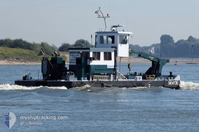
SIENTJE
Other Type

Current Trip
SLIEDRECHT
| Time Travelled | 1 day |
|---|---|
| Remaining Time | --- |
| Distance Travelled | 97.53 nm |
| Remaining Distance | --- |
| AVG Speed | 6.2 Noeuds |
| MAX Speed | 7.9 Noeuds |
| AVG Wind | 10.5 knots |
| MAX Wind | 13 knots |
| MIN Temp | -1.9°C / 28.58°F |
| MAX Temp | 3.8°C / 38.84°F |
| Tirant d eau | 2.3 m |
| Position reçue | 1 m depuis |
Current Position
| Longitude | --- |
|---|---|
| Latitude | --- |
| Etat | Moored |
| Vitesse | 6.3 Noeuds |
| Parcours | 241.2° |
| Zone | North Sea |
| Station | T-AIS |
| Position reçue | 1 m depuis |
Information
The current position of SIENTJE is in North Sea with coordinates 51.82195° / 4.89253° as reported on 2025-02-19 11:10 by AIS to our vessel tracker app. The vessel's current speed is 6.3 Noeuds
The vessel SIENTJE (MMSI: 244710939) is a Other Type It's sailing under the flag of [NL] Netherlands.
In this page you can find informations about the vessels current position, last detected port calls, and current voyage information. If the vessels is not in coverage by AIS you will find the latest position.
The current position of SIENTJE is detected by our AIS receivers and we are not responsible for the reliability of the data. The last position was recorded while the vessel was in Coverage by the Ais receivers of our vessel tracking app.
The current draught of SIENTJE as reported by AIS is 2.3 meters
Weather
| Temperature | 2.8°C / 37.04°F |
|---|---|
| Wind Speed | 10 knots |
| Direction | 127° SE |
| Pressure | 1022 hPa |
| Humidity | 39 % |
| Cloud Coverage | 100 % |


Featured Company
Last Port Calls
| Port | Arrival | Departure | Time In Port |
|---|---|---|---|
| 2025-02-17 07:40 | 2025-02-17 13:15 | 5 h | |
| 2025-02-11 20:31 | 2025-02-12 06:04 | 9 h | |
| 2025-02-06 13:29 | 2025-02-11 05:46 | 4 d | |
| 2025-02-05 19:50 | 2025-02-06 06:07 | 10 h | |
| 2025-02-05 14:26 | 2025-02-05 17:39 | 3 h | |
| 2025-02-03 08:14 | 2025-02-03 10:48 | 2 h | |
| 2025-01-30 16:08 | 2025-02-03 06:26 | 3 d | |
| 2025-01-29 13:41 | 2025-01-30 09:41 | 19 h | |
| 2025-01-28 17:50 | 2025-01-29 07:25 | 13 h | |
| 2025-01-22 16:59 | 2025-01-22 19:51 | 2 h |
Most Visited Ports (Last year)
| Port | Arrivals | |
|---|---|---|
| 20 | ||
| 9 | ||
| 8 | ||
| 8 | ||
| 8 | ||
| 6 |
Last Trips
| Origin | Departure | Destination | Arrival | Distance | |
|---|---|---|---|---|---|
| 2025-02-12 06:04 | 2025-02-17 07:40 | 45.18 nm | |||
| 2025-02-11 05:46 | 2025-02-11 20:31 | 60.14 nm | |||
| 2025-02-06 06:07 | 2025-02-06 13:29 | 34.68 nm | |||
| 2025-02-05 17:39 | 2025-02-05 19:50 | 8.53 nm | |||
| 2025-02-03 10:48 | 2025-02-05 14:26 | 136.47 nm | |||
| 2025-02-03 06:26 | 2025-02-03 08:14 | 8.96 nm | |||
| 2025-01-30 09:41 | 2025-01-30 16:08 | 34.14 nm | |||
| 2025-01-29 07:25 | 2025-01-29 13:41 | 34.93 nm | |||
| 2025-01-22 19:51 | 2025-01-28 17:50 | 37.25 nm | |||
| 2025-01-22 08:36 | 2025-01-22 16:59 | 43.08 nm |
Events
| Heure | Evenement | Détails | Position/ Destination | Info |
|---|---|---|---|---|
| 2025-02-19 05:38 | Démarrage | 0.51 nm, North of NIJMEGEN |
51.85556 / 5.82441
SLIEDRECHT
|
Vitesse: 4.5 kn Parcours: 27.2° |
| 2025-02-19 05:25 | Arret | 0.41 nm, North of NIJMEGEN |
51.85394 / 5.82309
SLIEDRECHT
|
Vitesse: 0.1 kn Parcours: 511° |
| 2025-02-19 04:10 | Démarrage | 1.1 nm, North of CUIJK |
51.77084 / 5.85134
SLIEDRECHT
|
Vitesse: 3.1 kn Parcours: 335.2° |
| 2025-02-18 20:06 | Arret | 0.76 nm, North of CUIJK |
51.76504 / 5.85563
SLIEDRECHT
|
Vitesse: 0.2 kn Parcours: 511° |
| 2025-02-18 18:23 | Démarrage | 1.84 nm, South East of BOXMEER |
51.64154 / 5.97911
SLIEDRECHT
|
Vitesse: 4.7 kn Parcours: 298.9° |
| 2025-02-18 17:59 | Arret | 1.94 nm, South East of BOXMEER |
51.64050 / 5.98177
SLIEDRECHT
|
Vitesse: 0.2 kn Parcours: 511° |
| 2025-02-18 16:40 | Dans la zone couverte |
51.54757 / 6.07895
North Sea
|
Vitesse: 5.9 kn Parcours: 290.9° |
|
| 2025-02-17 17:07 | Hors de la zone couverte |
51.26549 / 6.02246
North Sea
|
Vitesse: 5.4 kn Parcours: 80.6° |
|
| 2025-02-17 14:54 | Démarrage | 0.22 nm, North West of MAASBRACHT |
51.14650 / 5.88236
SLIEDRECHT
|
Vitesse: 4.9 kn Parcours: 41.2° |
| 2025-02-17 14:28 | Arret | 0.46 nm, South West of MAASBRACHT |
51.14153 / 5.87700
SLIEDRECHT
|
Vitesse: 0.2 kn Parcours: 511° |