

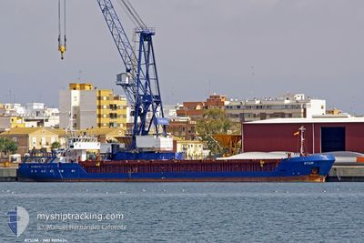
SEMSA
General Cargo

Current Trip
| Time Travelled | 4 days |
|---|---|
| Remaining Time | --- |
| Distance Travelled | 41.66 nm |
| Remaining Distance | --- |
| AVG Speed | 6.7 Noeuds |
| MAX Speed | 7.8 Noeuds |
| AVG Wind | 6.4 knots |
| MAX Wind | 17 knots |
| MIN Temp | 0.5°C / 32.9°F |
| MAX Temp | 12.7°C / 54.86°F |
| Tirant d eau | 4.3 m |
| Position reçue | 6 m depuis |
Current Position
| Longitude | --- |
|---|---|
| Latitude | --- |
| Etat | At anchor |
| Vitesse | |
| Parcours | 173° |
| Zone | Sea of Marmara |
| Station | T-AIS |
| Position reçue | 6 m depuis |
Information
The current position of SEMSA is in Sea of Marmara with coordinates 40.86944° / 29.19564° as reported on 2025-03-22 01:33 by AIS to our vessel tracker app. The vessel's current speed is 0 Noeuds and is heading at the port of SPLIT. The estimated time of arrival as calculated by MyShipTracking vessel tracking app is 2025-03-28 00:00 LT
The vessel SEMSA (IMO: 9015424, MMSI: 312453000) is a General Cargo that was built in 1991 ( 34 Age ). It's sailing under the flag of [BZ] Belize.
In this page you can find informations about the vessels current position, last detected port calls, and current voyage information. If the vessels is not in coverage by AIS you will find the latest position.
The current position of SEMSA is detected by our AIS receivers and we are not responsible for the reliability of the data. The last position was recorded while the vessel was in Coverage by the Ais receivers of our vessel tracking app.
The current draught of SEMSA as reported by AIS is 4.3 meters
Weather
| Temperature | 7.1°C / 44.78°F |
|---|---|
| Wind Speed | 6 knots |
| Direction | 127° SE |
| Pressure | 1024.5 hPa |
| Humidity | 58.2 % |
| Cloud Coverage | --- |


Featured Company
Last Port Calls
| Port | Arrival | Departure | Time In Port |
|---|---|---|---|
| 2025-03-16 16:05 | 2025-03-17 19:39 | 1 d | |
| 2025-03-10 07:24 | 2025-03-11 15:54 | 1 d | |
| 2025-03-03 10:17 | 2025-03-05 03:05 | 1 d | |
| 2025-02-25 07:38 | 2025-02-26 17:15 | 1 d | |
| 2025-02-19 09:41 | 2025-02-24 10:01 | 5 d | |
| 2025-02-10 04:21 | 2025-02-11 19:52 | 1 d | |
| 2025-01-27 08:11 | 2025-01-28 15:00 | 1 d | |
| 2025-01-18 00:34 | 2025-01-21 23:25 | 3 d | |
| 2025-01-08 12:26 | 2025-01-09 11:48 | 23 h |
Last Trips
| Origin | Departure | Destination | Arrival | Distance | |
|---|---|---|---|---|---|
| 2025-03-11 15:54 | 2025-03-16 16:05 | 521.34 nm | |||
| 2025-03-05 03:05 | 2025-03-10 07:24 | 585.87 nm | |||
| 2025-02-26 17:15 | 2025-03-03 10:17 | 554.87 nm | |||
| 2025-02-24 10:01 | 2025-02-25 07:38 | 61.16 nm | |||
| 2025-02-11 19:52 | 2025-02-19 09:41 | 1214.02 nm | |||
| 2025-01-28 15:00 | 2025-02-10 04:21 | 742.59 nm | |||
| 2025-01-21 23:25 | 2025-01-27 08:11 | 814.55 nm | |||
| 2025-01-09 11:48 | 2025-01-18 00:34 | 284.51 nm | |||
| 2024-12-29 16:23 | 2025-01-08 12:26 | 593.27 nm |
Events
| Heure | Evenement | Détails | Position/ Destination | Info |
|---|---|---|---|---|
| 2025-03-22 00:48 | Etat Changé | At anchor Default |
40.86952 / 29.19568
HRSPU
|
Vitesse: Parcours: 172° |
| 2025-03-22 00:36 | Etat Changé | Default At anchor |
40.86947 / 29.19560
HRSPU
|
Vitesse: Parcours: 174° |
| 2025-03-21 23:57 | Etat Changé | At anchor Default |
40.86946 / 29.19557
HRSPU
|
Vitesse: Parcours: 174° |
| 2025-03-21 23:48 | Etat Changé | Default At anchor |
40.86957 / 29.19559
HRSPU
|
Vitesse: 0.1 kn Parcours: 167° |
| 2025-03-21 22:48 | Etat Changé | At anchor Default |
40.86936 / 29.19549
HRSPU
|
Vitesse: 0.3 kn Parcours: 112° |
| 2025-03-21 22:39 | Etat Changé | Default At anchor |
40.86902 / 29.19497
HRSPU
|
Vitesse: 0.3 kn Parcours: 101° |
| 2025-03-21 22:34 | Etat Changé | At anchor Under way sailing |
40.86871 / 29.19475
HRSPU
|
Vitesse: 0.3 kn Parcours: 88° |
| 2025-03-21 22:30 | Arret | 0.89 nm, South West of KARTAL |
40.86844 / 29.19496
HRSPU
|
Vitesse: 0.3 kn Parcours: 71° |
| 2025-03-21 16:53 | Démarrage | 1.01 nm, North of AUTOPORT |
40.73915 / 29.88359
HRSPU
|
Vitesse: 5.4 kn Parcours: 278.1° |
| 2025-03-21 16:29 | Changement d'ETA | 2025/03/27 23:00 2025/03/25 18:00 |
40.74003 / 29.88708
HRSPU
|
Vitesse: Parcours: 111° |