
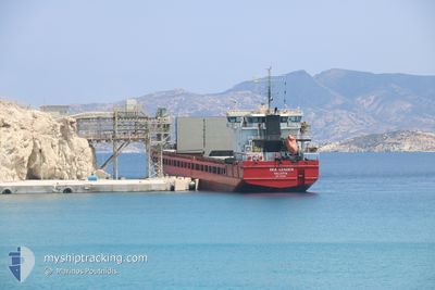
SEA LEADER
General Cargo
Current Trip
| Trip Time | 8 days |
|---|---|
| Trip Distance | 1115.28 nm |
| AVG Speed | 5.8 Noeuds |
| MAX Speed | 8.4 Noeuds |
| Tirant d eau | 4.5 m |
| AVG Wind | 12.7 knots |
| MAX Wind | 28 knots |
| MIN Temp | 6.6°C / 43.88°F |
| MAX Temp | 21.7°C / 71.06°F |
| Position reçue | 3 d depuis |
Current Position
| Longitude | 29.10987° |
|---|---|
| Latitude | 41.49275° |
| Etat | Under way using engine |
| Vitesse | 6.9 Noeuds |
| Parcours | 333.8° |
| Zone | Black Sea |
| Station | T-AIS |
| Position reçue | 3 d depuis |
Info
Information
The current position of SEA LEADER is in Black Sea with coordinates 41.49275° / 29.10987° as reported on 2024-05-08 16:30 by AIS to our vessel tracker app. The vessel's current speed is 6.9 Noeuds and is currently inside the port of VARNA.
The vessel SEA LEADER (IMO: 9363998, MMSI: 229939000) is a General Cargo that was built in 2007 ( 17 Age ). It's sailing under the flag of [MT] Malta.
In this page you can find informations about the vessels current position, last detected port calls, and current voyage information. If the vessels is not in coverage by AIS you will find the latest position.
The current position of SEA LEADER is detected by our AIS receivers and we are not responsible for the reliability of the data. The last position was recorded while the vessel was in Coverage by the Ais receivers of our vessel tracking app.
The current draught of SEA LEADER as reported by AIS is 4.5 meters
Weather
| Temperature | 13.2°C / 55.76°F |
|---|---|
| Wind Speed | 3 knots |
| Direction | 186° S |
| Pressure | 1016 hPa |
| Humidity | 69.6 % |
| Cloud Coverage | 100 % |
Featured Company
Last Port Calls
| Port | Arrival | Departure | Time In Port |
|---|---|---|---|
| 2024-05-09 11:40 | |||
| 2024-04-24 13:56 | 2024-05-01 06:54 | 6 d | |
| 2024-04-19 07:26 | 2024-04-22 17:22 | 3 d | |
| 2024-04-02 23:29 | 2024-04-14 14:32 | 11 d | |
| 2024-03-26 18:29 | 2024-03-28 14:38 | 1 d | |
| 2024-03-15 14:47 | 2024-03-20 18:47 | 5 d | |
| 2024-03-09 07:28 | 2024-03-12 07:00 | 2 d | |
| 2024-03-01 04:39 | 2024-03-02 11:25 | 1 d |
Last Trips
| Origin | Departure | Destination | Arrival | Distance | |
|---|---|---|---|---|---|
| 2024-05-01 08:54 | 2024-05-09 14:40 | 1115.28 nm | |||
| 2024-04-22 19:22 | 2024-04-24 15:56 | 171.45 nm | |||
| 2024-04-14 17:32 | 2024-04-19 09:26 | 800.00 nm | |||
| 2024-03-28 17:38 | 2024-04-03 02:29 | 97.63 nm | |||
| 2024-03-20 19:47 | 2024-03-26 21:29 | 679.81 nm | |||
| 2024-03-12 08:00 | 2024-03-15 15:47 | 146.22 nm | |||
| 2024-03-02 12:25 | 2024-03-09 08:28 | 1127.77 nm | |||
| 2024-02-28 14:14 | 2024-03-01 05:39 | 236.84 nm |
Events
| Heure | Evenement | Détails | Position/ Destination | Info |
|---|---|---|---|---|
| 2024-05-09 13:36 | Arret |
43.18919 / 27.65659
[BG] VARNA
|
Vitesse: Parcours: 270° |
|
| 2024-05-09 11:40 | Port d'arrivée |
|
43.18380 / 27.91200
[BG] VARNA
|
Vitesse: 7.2 kn Parcours: 255° |
| 2024-05-08 16:34 | Etat Changé | Default Under way using engine |
41.49858 / 29.10628
BG VAR
|
Vitesse: 6.9 kn Parcours: 333.8° |
| 2024-05-08 16:30 | Hors de la zone couverte |
41.49275 / 29.10987
Black Sea
|
Vitesse: 6.9 kn Parcours: 333.8° |
|
| 2024-05-08 13:53 | Changement de zone | Turkish part of the Black Sea Turkish part of the Sea of Marmara |
41.23305 / 29.14267
Black Sea
|
Vitesse: 7.2 kn Parcours: 33.3° |
| 2024-05-08 06:41 | Démarrage | 17.2 nm, South of YESILKOY |
40.67048 / 28.86828
BG VAR
|
Vitesse: 3.1 kn Parcours: 343° |
| 2024-05-07 23:41 | Arret | 15.95 nm, South of YESILKOY |
40.69619 / 28.90467
BG VAR
|
Vitesse: 0.3 kn Parcours: 310° |
| 2024-05-07 22:03 | Démarrage | 13.02 nm, South West of MALTEPE |
40.75399 / 28.93693
BG VAR
|
Vitesse: 7.9 kn Parcours: 197.9° |
| 2024-05-07 22:02 | Arret | 12.89 nm, South West of MALTEPE |
40.75646 / 28.93759
BG VAR
|
Vitesse: Parcours: 199° |
| 2024-05-07 22:00 | Démarrage | 12.73 nm, South West of MALTEPE |
40.75940 / 28.93874
BG VAR
|
Vitesse: 8.1 kn Parcours: 192.3° |