
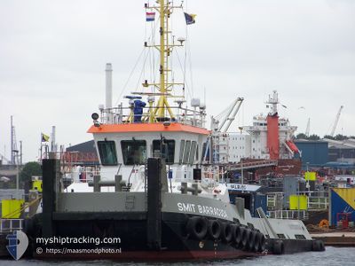
SEA BARRACUDA
Tug
Current Trip
NMDC
| Time Travelled | --- |
|---|---|
| Remaining Time | --- |
| Distance Travelled | 1280.71 nm |
| Remaining Distance | --- |
| AVG Speed | 5.2 Noeuds |
| MAX Speed | 5.2 Noeuds |
| AVG Wind | 10 knots |
| MAX Wind | 25 knots |
| MIN Temp | 18.2°C / 64.76°F |
| MAX Temp | 27.9°C / 82.22°F |
| Tirant d eau | 2.7 m |
| Position reçue | 4 h, 43 m depuis |
Current Position
| Longitude | --- |
|---|---|
| Latitude | --- |
| Etat | Under way using engine |
| Vitesse | |
| Parcours | 133° |
| Zone | Persian Gulf |
| Station | T-AIS |
| Position reçue | 4 h, 43 m depuis |
Info
Information
The current position of SEA BARRACUDA is in Persian Gulf with coordinates 24.68438° / 54.50663° as reported on 2025-02-26 11:56 by AIS to our vessel tracker app. The vessel's current speed is 0 Noeuds
The vessel SEA BARRACUDA (IMO: 9345506, MMSI: 246070000) is a Tug that was built in 2006 ( 19 Age ). It's sailing under the flag of [NL] Netherlands.
In this page you can find informations about the vessels current position, last detected port calls, and current voyage information. If the vessels is not in coverage by AIS you will find the latest position.
The current position of SEA BARRACUDA is detected by our AIS receivers and we are not responsible for the reliability of the data. The last position was recorded while the vessel was in Coverage by the Ais receivers of our vessel tracking app.
The current draught of SEA BARRACUDA as reported by AIS is 2.7 meters
Weather
| Temperature | 18.9°C / 66.02°F |
|---|---|
| Wind Speed | 12 knots |
| Direction | 302° WNW |
| Pressure | 1019.3 hPa |
| Humidity | 58.9 % |
| Cloud Coverage | 100 % |
Featured Company
Events
| Heure | Evenement | Détails | Position/ Destination | Info |
|---|---|---|---|---|
| 2025-02-26 16:29 | Démarrage | 7.61 nm, South West of KHALIFA |
24.73307 / 54.55499
NMDC
|
Vitesse: 6.4 kn Parcours: 240° |
| 2025-02-26 14:29 | Arret | 7.38 nm, South West of KHALIFA |
24.73448 / 54.55907
NMDC
|
Vitesse: 0.1 kn Parcours: 78° |
| 2025-02-26 13:59 | Démarrage | 9.55 nm, South West of KHALIFA |
24.69945 / 54.53927
NMDC
|
Vitesse: 6.4 kn Parcours: 50° |
| 2025-02-26 12:03 | Etat Changé | Default Under way using engine |
24.68435 / 54.50660
NMDC
|
Vitesse: Parcours: 133° |
| 2025-02-26 11:56 | Hors de la zone couverte |
24.68438 / 54.50663
Persian Gulf
|
Vitesse: Parcours: 1° |
|
| 2025-02-26 11:22 | Etat Changé | Under way using engine Default |
24.68437 / 54.50662
NMDC
|
Vitesse: 0.1 kn Parcours: 128° |
| 2025-02-26 11:18 | Etat Changé | Default Under way using engine |
24.68442 / 54.50668
NMDC
|
Vitesse: 0.2 kn Parcours: 132° |
| 2025-02-26 09:51 | Arret | 11.49 nm, South West of KHALIFA |
24.68438 / 54.50652
NMDC
|
Vitesse: 0.2 kn Parcours: 114° |
| 2025-02-26 09:06 | Démarrage | 7.61 nm, South West of KHALIFA |
24.73253 / 54.55548
NMDC
|
Vitesse: 6.5 kn Parcours: 212° |
| 2025-02-26 08:47 | Arret | 7.39 nm, South West of KHALIFA |
24.73452 / 54.55893
NMDC
|
Vitesse: 0.3 kn Parcours: 152° |