
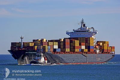
SC MONTREUX
Container Ship
Current Trip
| Time Travelled | 1 day |
|---|---|
| Remaining Time | --- |
| Distance Travelled | 772.75 nm |
| Remaining Distance | --- |
| AVG Speed | 16.6 Noeuds |
| MAX Speed | 19.9 Noeuds |
| AVG Wind | 13.4 knots |
| MAX Wind | 26 knots |
| MIN Temp | 11.8°C / 53.24°F |
| MAX Temp | 19.1°C / 66.38°F |
| Tirant d eau | 10.5 m |
| Position reçue | 3 m depuis |
Current Position
| Longitude | 16.56751° |
|---|---|
| Latitude | 36.37281° |
| Etat | Under way using engine |
| Vitesse | 18 Noeuds |
| Parcours | 270° |
| Zone | Mediterranean Sea - Eastern Basin |
| Station | T-AIS |
| Position reçue | 3 m depuis |
Info
Information
The current position of SC MONTREUX is in Mediterranean Sea - Eastern Basin with coordinates 36.37281° / 16.56751° as reported on 2024-05-02 14:45 by AIS to our vessel tracker app. The vessel's current speed is 18 Noeuds and is heading at the port of TANGER MED. The estimated time of arrival as calculated by MyShipTracking vessel tracking app is 2024-05-05 04:30 LT
The vessel SC MONTREUX (IMO: 9295414, MMSI: 538008593) is a Container Ship that was built in 2005 ( 19 Age ). It's sailing under the flag of [MH] Marshall Is.
In this page you can find informations about the vessels current position, last detected port calls, and current voyage information. If the vessels is not in coverage by AIS you will find the latest position.
The current position of SC MONTREUX is detected by our AIS receivers and we are not responsible for the reliability of the data. The last position was recorded while the vessel was in Coverage by the Ais receivers of our vessel tracking app.
The current draught of SC MONTREUX as reported by AIS is 10.5 meters
Weather
| Temperature | 18.2°C / 64.76°F |
|---|---|
| Wind Speed | 11 knots |
| Direction | 270° W |
| Pressure | 1015 hPa |
| Humidity | 77.4 % |
| Cloud Coverage | --- |
Featured Company
Last Port Calls
| Port | Arrival | Departure | Time In Port |
|---|---|---|---|
| 2024-04-29 21:26 | 2024-04-30 17:05 | 19 h | |
| 2024-04-27 19:08 | 2024-04-28 21:38 | 1 d | |
| 2024-04-27 03:45 | 2024-04-27 14:22 | 10 h | |
| 2024-04-25 00:04 | 2024-04-25 20:00 | 19 h | |
| 2024-04-20 01:41 | 2024-04-20 10:07 | 8 h | |
| 2024-04-19 15:01 | 2024-04-19 22:15 | 7 h | |
| 2024-04-18 17:01 | 2024-04-19 11:43 | 18 h | |
| 2024-04-11 21:14 | 2024-04-12 18:28 | 21 h | |
| 2024-04-09 06:29 | 2024-04-11 15:43 | 2 d | |
| 2024-04-06 20:30 | 2024-04-08 05:05 | 1 d |
Last Trips
| Origin | Departure | Destination | Arrival | Distance | |
|---|---|---|---|---|---|
| 2024-04-29 00:38 | 2024-04-30 00:26 | 71.62 nm | |||
| 2024-04-27 17:22 | 2024-04-27 22:08 | 53.69 nm | |||
| 2024-04-25 23:00 | 2024-04-27 06:45 | 401.03 nm | |||
| 2024-04-20 12:07 | 2024-04-25 03:04 | 1541.75 nm | |||
| 2024-04-19 23:15 | 2024-04-20 03:41 | 22.40 nm | |||
| 2024-04-19 13:43 | 2024-04-19 16:01 | 24.98 nm | |||
| 2024-04-12 21:28 | 2024-04-18 19:01 | 1955.87 nm | |||
| 2024-04-11 18:43 | 2024-04-12 00:14 | 55.51 nm | |||
| 2024-04-08 08:05 | 2024-04-09 09:29 | 323.06 nm | |||
| 2024-04-06 08:25 | 2024-04-06 23:30 | 276.70 nm |
Events
| Heure | Evenement | Détails | Position/ Destination | Info |
|---|---|---|---|---|
| 2024-05-02 14:43 | Changement de zone | Italian part of the Mediterranean Sea - Eastern Basin Greek part of the Mediterranean Sea - Eastern Basin |
36.37283 / 16.58106
Mediterranean Sea - Eastern Basin
TANGER MED
|
Vitesse: 18 kn Parcours: 269.6° |
| 2024-05-02 14:43 | Etat Changé | Under way using engine Default |
36.37283 / 16.58106
TANGER MED
|
Vitesse: 18 kn Parcours: 269° |
| 2024-05-02 14:43 | Dans la zone couverte |
36.37283 / 16.58106
Mediterranean Sea - Eastern Basin
TANGER MED
|
Vitesse: 18 kn Parcours: 269.6° |
|
| 2024-05-02 00:06 | Etat Changé | Default Under way using engine |
36.32761 / 22.08524
TANGER MED
|
Vitesse: 18 kn Parcours: 268.8° |
| 2024-05-01 23:56 | Hors de la zone couverte |
36.32837 / 22.14913
Mediterranean Sea - Eastern Basin
TANGER MED
|
Vitesse: 18 kn Parcours: 268.8° |
|
| 2024-05-01 21:29 | Changement de zone | Greek part of the Mediterranean Sea - Eastern Basin Greek part of the Aegean Sea |
36.40731 / 23.04097
Mediterranean Sea - Eastern Basin
TANGER MED
|
Vitesse: 17.6 kn Parcours: 278.5° |
| 2024-05-01 21:19 | Etat Changé | Under way using engine Default |
36.40047 / 23.10243
TANGER MED
|
Vitesse: 17.7 kn Parcours: 276° |
| 2024-05-01 21:10 | Etat Changé | Default Under way using engine |
36.39568 / 23.15596
TANGER MED
|
Vitesse: 17.9 kn Parcours: 275.9° |
| 2024-05-01 20:45 | Etat Changé | Under way using engine Default |
36.38713 / 23.30553
TANGER MED
|
Vitesse: 17.6 kn Parcours: 247° |
| 2024-05-01 20:17 | Etat Changé | Default Under way using engine |
36.45593 / 23.43593
TANGER MED
|
Vitesse: 17.9 kn Parcours: 213.1° |