
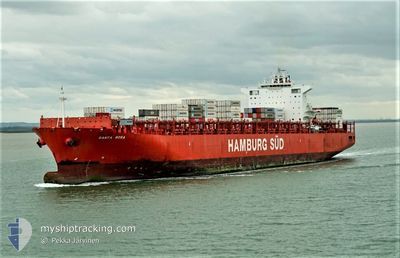
SANTA ROSA
Container Ship
Current Trip
EGPSD > MAPTM2
| Time Travelled | 10 days |
|---|---|
| Remaining Time | --- |
| Distance Travelled | 2534.54 nm |
| Remaining Distance | --- |
| AVG Speed | 11.5 Noeuds |
| MAX Speed | 22.3 Noeuds |
| AVG Wind | 11.9 knots |
| MAX Wind | 32 knots |
| MIN Temp | 12.2°C / 53.96°F |
| MAX Temp | 27.8°C / 82.04°F |
| Tirant d eau | 11 m |
| Position reçue | 13 m depuis |
Current Position
| Longitude | -2.31246° |
|---|---|
| Latitude | 36.27689° |
| Etat | Under way using engine |
| Vitesse | 11.5 Noeuds |
| Parcours | 262.3° |
| Zone | Alboran Sea |
| Station | T-AIS |
| Position reçue | 13 m depuis |
Info
Information
The current position of SANTA ROSA is in Alboran Sea with coordinates 36.27689° / -2.31246° as reported on 2024-04-28 05:37 by AIS to our vessel tracker app. The vessel's current speed is 11.5 Noeuds
The vessel SANTA ROSA (IMO: 9430363, MMSI: 219086000) is a Container Ship that was built in 2011 ( 13 Age ). It's sailing under the flag of [DK] Denmark.
In this page you can find informations about the vessels current position, last detected port calls, and current voyage information. If the vessels is not in coverage by AIS you will find the latest position.
The current position of SANTA ROSA is detected by our AIS receivers and we are not responsible for the reliability of the data. The last position was recorded while the vessel was in Coverage by the Ais receivers of our vessel tracking app.
The current draught of SANTA ROSA as reported by AIS is 11 meters
Weather
| Temperature | 16.7°C / 62.06°F |
|---|---|
| Wind Speed | 11 knots |
| Direction | 264° W |
| Pressure | 1010 hPa |
| Humidity | 74.1 % |
| Cloud Coverage | 100 % |
Featured Company
Last Port Calls
| Port | Arrival | Departure | Time In Port |
|---|---|---|---|
| 2024-04-19 22:32 | 2024-04-21 03:19 | 1 d | |
| 2024-04-19 04:04 | |||
| 2024-04-16 01:54 | 2024-04-17 19:08 | 1 d | |
| 2024-04-12 03:57 | 2024-04-13 11:52 | 1 d | |
| 2024-04-07 02:26 | 2024-04-08 01:22 | 22 h | |
| 2024-03-27 04:05 | 2024-03-28 17:13 | 1 d | |
| 2024-03-24 05:43 | 2024-03-24 14:00 | 8 h | |
| 2024-03-22 08:51 | 2024-03-23 19:35 | 1 d | |
| 2024-03-19 07:47 | 2024-03-20 11:39 | 1 d | |
| 2024-03-14 12:13 | 2024-03-15 05:49 | 17 h |
Most Visited Ports (Last year)
| Port | Arrivals | |
|---|---|---|
| 17 | ||
| 7 | ||
| 7 | ||
| 6 | ||
| 6 | ||
| 4 |
Last Trips
| Origin | Departure | Destination | Arrival | Distance | |
|---|---|---|---|---|---|
| 2024-04-17 22:08 | 2024-04-20 00:32 | 730.02 nm | |||
| 2024-04-17 22:08 | 2024-04-19 06:04 | 627.26 nm | |||
| 2024-04-08 01:22 | 2024-04-16 04:54 | 2859.44 nm | |||
| 2024-04-08 01:22 | 2024-04-12 05:57 | 1944.48 nm | |||
| 2024-03-24 17:00 | 2024-04-07 02:26 | 2689.85 nm | |||
| 2024-03-24 17:00 | 2024-03-27 06:05 | 592.49 nm | |||
| 2024-03-23 22:35 | 2024-03-24 08:43 | 86.77 nm | |||
| 2024-03-15 05:49 | 2024-03-22 11:51 | 2654.67 nm | |||
| 2024-03-15 05:49 | 2024-03-19 09:47 | 1933.34 nm | |||
| 2024-03-01 13:46 | 2024-03-14 12:13 | 2702.21 nm |
Events
| Heure | Evenement | Détails | Position/ Destination | Info |
|---|---|---|---|---|
| 2024-04-28 05:45 | Etat Changé | Default Under way using engine |
36.27167 / -2.34833
EGPSD > MAPTM2
|
Vitesse: 11.5 kn Parcours: 262.3° |
| 2024-04-28 05:37 | Etat Changé | Under way using engine Default |
36.27689 / -2.31246
EGPSD > MAPTM2
|
Vitesse: 11 kn Parcours: 263° |
| 2024-04-28 05:30 | Etat Changé | Default Under way using engine |
36.27833 / -2.28833
EGPSD > MAPTM2
|
Vitesse: 11.5 kn Parcours: 262.4° |
| 2024-04-28 05:23 | Etat Changé | Under way using engine Default |
36.28305 / -2.25106
EGPSD > MAPTM2
|
Vitesse: 11 kn Parcours: 262° |
| 2024-04-28 05:18 | Etat Changé | Default Under way using engine |
36.28333 / -2.24167
EGPSD > MAPTM2
|
Vitesse: 11.4 kn Parcours: 262.9° |
| 2024-04-28 05:07 | Detecté en mer | Spanish part of the Alboran Sea |
36.28872 / -2.19689
Alboran Sea
EGPSD > MAPTM2
|
Vitesse: 11.4 kn Parcours: 262.9° |
| 2024-04-28 05:07 | Etat Changé | Under way using engine Default |
36.28872 / -2.19689
EGPSD > MAPTM2
|
Vitesse: 11 kn Parcours: 263° |
| 2024-04-28 05:07 | Dans la zone couverte |
36.28872 / -2.19689
Alboran Sea
EGPSD > MAPTM2
|
Vitesse: 11.4 kn Parcours: 262.9° |
|
| 2024-04-28 03:06 | Etat Changé | Default Under way using engine |
36.35500 / -1.73333
EGPSD > MAPTM2
|
Vitesse: 11.2 kn Parcours: 258.7° |
| 2024-04-28 02:59 | Hors de la zone couverte |
36.36257 / -1.69603
Mediterranean Sea - Western Basin
EGPSD > MAPTM2
|
Vitesse: 11.2 kn Parcours: 258.7° |