
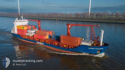
SAMSKIP COMMANDER
General Cargo
Current Trip
| Trip Time | 1 day |
|---|---|
| Trip Distance | 454.92 nm |
| AVG Speed | 10 Noeuds |
| MAX Speed | 13.8 Noeuds |
| Tirant d eau | 5.7 m |
| AVG Wind | 8.9 knots |
| MAX Wind | 21 knots |
| MIN Temp | 13.6°C / 56.48°F |
| MAX Temp | 18°C / 64.4°F |
| Position reçue | 3 m depuis |
Current Position
| Longitude | 4.42205° |
|---|---|
| Latitude | 51.87814° |
| Etat | Moored |
| Vitesse | 0.2 Noeuds |
| Parcours | 108° |
| Zone | North Sea |
| Station | T-AIS |
| Position reçue | 3 m depuis |
Info
Information
The current position of SAMSKIP COMMANDER is in North Sea with coordinates 51.87814° / 4.42205° as reported on 2024-07-27 14:23 by AIS to our vessel tracker app. The vessel's current speed is 0.2 Noeuds and is currently inside the port of ROTTERDAM WAALHAVEN.
The vessel SAMSKIP COMMANDER (IMO: 9143829, MMSI: 314292000) is a General Cargo that was built in 1997 ( 27 Age ). It's sailing under the flag of [BB] Barbados.
In this page you can find informations about the vessels current position, last detected port calls, and current voyage information. If the vessels is not in coverage by AIS you will find the latest position.
The current position of SAMSKIP COMMANDER is detected by our AIS receivers and we are not responsible for the reliability of the data. The last position was recorded while the vessel was in Coverage by the Ais receivers of our vessel tracking app.
The current draught of SAMSKIP COMMANDER as reported by AIS is 6.1 meters
Weather
| Temperature | 20.2°C / 68.36°F |
|---|---|
| Wind Speed | 9 knots |
| Direction | 253° WSW |
| Pressure | 1014 hPa |
| Humidity | 63.1 % |
| Cloud Coverage | 100 % |
Featured Company
Last Port Calls
| Port | Arrival | Departure | Time In Port |
|---|---|---|---|
| 2024-07-27 02:29 | |||
| 2024-07-25 04:18 | 2024-07-25 07:31 | 3 h | |
| 2024-07-23 18:27 | 2024-07-24 04:52 | 10 h | |
| 2024-07-22 23:09 | 2024-07-23 05:46 | 6 h | |
| 2024-07-22 12:54 | 2024-07-22 16:04 | 3 h | |
| 2024-07-22 07:47 | 2024-07-22 10:37 | 2 h | |
| 2024-07-20 02:09 | 2024-07-20 18:38 | 16 h | |
| 2024-07-18 07:43 | 2024-07-18 10:43 | 3 h | |
| 2024-07-16 20:45 | 2024-07-17 09:37 | 12 h | |
| 2024-07-15 23:11 | 2024-07-16 08:22 | 9 h |
Most Visited Ports (Last year)
| Port | Arrivals | |
|---|---|---|
| 57 | ||
| 51 | ||
| 42 | ||
| 27 | ||
| 23 | ||
| 21 |
Last Trips
| Origin | Departure | Destination | Arrival | Distance | |
|---|---|---|---|---|---|
| 2024-07-25 07:31 | 2024-07-27 02:29 | 454.92 nm | |||
| 2024-07-24 04:52 | 2024-07-25 04:18 | 268.34 nm | |||
| 2024-07-23 05:46 | 2024-07-23 18:27 | 170.16 nm | |||
| 2024-07-22 16:04 | 2024-07-22 23:09 | 78.00 nm | |||
| 2024-07-22 10:37 | 2024-07-22 12:54 | 27.01 nm | |||
| 2024-07-20 18:38 | 2024-07-22 07:47 | 446.81 nm | |||
| 2024-07-18 10:43 | 2024-07-20 02:09 | 455.50 nm | |||
| 2024-07-17 09:37 | 2024-07-18 07:43 | 253.75 nm | |||
| 2024-07-16 08:22 | 2024-07-16 20:45 | 169.91 nm | |||
| 2024-07-15 17:36 | 2024-07-15 23:11 | 76.66 nm |
Events
| Heure | Evenement | Détails | Position/ Destination | Info |
|---|---|---|---|---|
| 2024-07-27 14:11 | Tirant d'eau modifié | 6.1 5.7 |
51.87815 / 4.42205
[NL] ROTTERDAM WAALHAVEN
|
Vitesse: Parcours: 108° |
| 2024-07-27 14:11 | Changement de destination | NOTAE NLRTM |
51.87815 / 4.42205
[NL] ROTTERDAM WAALHAVEN
|
Vitesse: Parcours: 108° |
| 2024-07-27 14:11 | Changement d'ETA | 2024/07/29 06:00 2024/07/26 22:00 |
51.87815 / 4.42205
[NL] ROTTERDAM WAALHAVEN
|
Vitesse: Parcours: 108° |
| 2024-07-27 11:25 | Etat Changé | Moored Default |
51.87815 / 4.42205
[NL] ROTTERDAM WAALHAVEN
|
Vitesse: Parcours: 108° |
| 2024-07-27 11:23 | Etat Changé | Default Moored |
51.87815 / 4.42205
[NL] ROTTERDAM WAALHAVEN
|
Vitesse: Parcours: 108° |
| 2024-07-27 00:39 | Etat Changé | Moored Under way using engine |
51.87813 / 4.42207
[NL] ROTTERDAM WAALHAVEN
|
Vitesse: Parcours: 109° |
| 2024-07-27 00:32 | Arret |
51.87822 / 4.42198
[NL] ROTTERDAM WAALHAVEN
|
Vitesse: 0.3 kn Parcours: 110° |
|
| 2024-07-27 00:29 | Port d'arrivée |
|
51.87844 / 4.42135
[NL] ROTTERDAM WAALHAVEN
|
Vitesse: 0.6 kn Parcours: 113° |
| 2024-07-26 20:46 | Changement d'ETA | 2024/07/26 22:00 2024/07/26 14:30 |
52.19328 / 3.77999
NLRTM
|
Vitesse: 6.6 kn Parcours: 181.1° |
| 2024-07-26 19:26 | Etat Changé | Under way using engine Default |
52.36193 / 3.80583
NLRTM
|
Vitesse: 9.4 kn Parcours: 192° |