

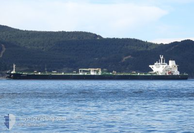
SAKARYA
Crude Oil Tanker

Current Trip
| Time Travelled | --- |
|---|---|
| Remaining Time | --- |
| Distance Travelled | 9533.99 nm |
| Remaining Distance | --- |
| AVG Speed | 11.6 Noeuds |
| MAX Speed | 16.1 Noeuds |
| AVG Wind | 9.6 knots |
| MAX Wind | 26 knots |
| MIN Temp | 0.2°C / 32.36°F |
| MAX Temp | 27.9°C / 82.22°F |
| Tirant d eau | 9.3 m |
| Position reçue | 9 d depuis |
Current Position
| Longitude | --- |
|---|---|
| Latitude | --- |
| Etat | Under way using engine |
| Vitesse | 12.9 Noeuds |
| Parcours | 304.9° |
| Zone | Gulf of Suez |
| Station | T-AIS |
| Position reçue | 9 d depuis |
Information
The current position of SAKARYA is in Gulf of Suez with coordinates 27.68949° / 33.91535° as reported on 2025-03-12 18:44 by AIS to our vessel tracker app. The vessel's current speed is 12.9 Noeuds
The vessel SAKARYA (IMO: 9524463, MMSI: 352002168) is a Crude Oil Tanker that was built in 2011 ( 14 Age ). It's sailing under the flag of [PA] Panama.
In this page you can find informations about the vessels current position, last detected port calls, and current voyage information. If the vessels is not in coverage by AIS you will find the latest position.
The current position of SAKARYA is detected by our AIS receivers and we are not responsible for the reliability of the data. The last position was recorded while the vessel was in Coverage by the Ais receivers of our vessel tracking app.
The current draught of SAKARYA as reported by AIS is 9.3 meters
Weather
| Temperature | 20.3°C / 68.54°F |
|---|---|
| Wind Speed | 8 knots |
| Direction | 319° NW |
| Pressure | 1017.4 hPa |
| Humidity | 52.3 % |
| Cloud Coverage | --- |


Featured Company
Last Port Calls
| Port | Arrival | Departure | Time In Port |
|---|---|---|---|
| 2025-02-16 12:25 | 2025-02-16 21:38 | 9 h | |
| 2025-01-17 14:17 | 2025-01-18 00:01 | 9 h |
Most Visited Ports (Last year)
| Port | Arrivals | |
|---|---|---|
| 8 | ||
| 1 | ||
| 1 | ||
| 1 |
Last Trips
| Origin | Departure | Destination | Arrival | Distance | |
|---|---|---|---|---|---|
| 2024-11-22 17:01 | 2025-02-16 12:25 | 8412.52 nm | |||
| 2024-11-22 17:01 | 2025-01-17 14:17 | 12538.77 nm |
Events
| Heure | Evenement | Détails | Position/ Destination | Info |
|---|---|---|---|---|
| 2025-03-13 06:23 | Arret | 12.18 nm, East of SOKHNA |
29.69965 / 32.58617
EGSUZ
|
Vitesse: 0.3 kn Parcours: 343° |
| 2025-03-12 18:44 | Etat Changé | Default Under way using engine |
27.69087 / 33.91316
EGSUZ
|
Vitesse: 12.9 kn Parcours: 304.9° |
| 2025-03-12 18:44 | Hors de la zone couverte |
27.68949 / 33.91535
Gulf of Suez
EGSUZ
|
Vitesse: 12.9 kn Parcours: 304.9° |
|
| 2025-03-12 18:37 | Etat Changé | Under way using engine Default |
27.67662 / 33.93573
EGSUZ
|
Vitesse: 13.1 kn Parcours: 306° |
| 2025-03-12 17:46 | Etat Changé | Default Under way using engine |
27.56392 / 34.10075
EGSUZ
|
Vitesse: 12.8 kn Parcours: 309.9° |
| 2025-03-12 17:41 | Changement de zone | Egyptian part of the Gulf of Suez Egyptian part of the Red Sea |
27.55173 / 34.11708
Gulf of Suez
EGSUZ
|
Vitesse: 12.8 kn Parcours: 309.7° |