

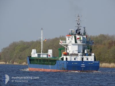
ROSI
General Cargo

Current Trip
| Time Travelled | 6 days |
|---|---|
| Remaining Time | --- |
| Distance Travelled | 1466.94 nm |
| Remaining Distance | --- |
| AVG Speed | 9.5 Noeuds |
| MAX Speed | 13.4 Noeuds |
| AVG Wind | 14.5 knots |
| MAX Wind | 25.8 knots |
| MIN Temp | -2.6°C / 27.32°F |
| MAX Temp | 13.1°C / 55.58°F |
| Tirant d eau | 5.4 m |
| Position reçue | 22 h, 47 m depuis |
Current Position
| Longitude | --- |
|---|---|
| Latitude | --- |
| Etat | Under way using engine |
| Vitesse | 9.3 Noeuds |
| Parcours | 211.6° |
| Zone | Celtic Sea |
| Station | T-AIS |
| Position reçue | 22 h, 47 m depuis |
Information
The current position of ROSI is in Celtic Sea with coordinates 48.17459° / -6.40374° as reported on 2025-02-18 12:19 by AIS to our vessel tracker app. The vessel's current speed is 9.3 Noeuds and is heading at the port of BEJAIA. The estimated time of arrival as calculated by MyShipTracking vessel tracking app is 2025-02-24 12:00 LT
The vessel ROSI (IMO: 9517238, MMSI: 255805952) is a General Cargo that was built in 2010 ( 15 Age ). It's sailing under the flag of [PT] Portugal.
In this page you can find informations about the vessels current position, last detected port calls, and current voyage information. If the vessels is not in coverage by AIS you will find the latest position.
The current position of ROSI is detected by our AIS receivers and we are not responsible for the reliability of the data. The last position was recorded while the vessel was in Coverage by the Ais receivers of our vessel tracking app.
The current draught of ROSI as reported by AIS is 5.4 meters
Weather
| Temperature | 12.8°C / 55.04°F |
|---|---|
| Wind Speed | 20 knots |
| Direction | 199° SSW |
| Pressure | 1014.7 hPa |
| Humidity | 83.4 % |
| Cloud Coverage | 100 % |


Featured Company
Last Port Calls
| Port | Arrival | Departure | Time In Port |
|---|---|---|---|
| 2025-02-09 06:20 | 2025-02-12 21:11 | 3 d | |
| 2025-02-08 07:36 | 2025-02-08 17:50 | 10 h | |
| 2025-02-01 07:13 | 2025-02-04 08:53 | 3 d | |
| 2025-01-21 22:14 | 2025-01-23 09:58 | 1 d | |
| 2025-01-18 15:51 | 2025-01-20 22:59 | 2 d | |
| 2025-01-14 18:51 | 2025-01-15 16:58 | 22 h | |
| 2025-01-02 06:09 | 2025-01-04 14:03 | 2 d | |
| 2024-12-14 12:49 | 2024-12-16 04:18 | 1 d | |
| 2024-12-10 13:55 | 2024-12-12 19:45 | 2 d |
Last Trips
| Origin | Departure | Destination | Arrival | Distance | |
|---|---|---|---|---|---|
| 2025-02-08 18:50 | 2025-02-09 07:20 | 14.73 nm | |||
| 2025-02-04 09:53 | 2025-02-08 08:36 | 278.67 nm | |||
| 2025-01-23 10:58 | 2025-02-01 08:13 | 1986.32 nm | |||
| 2025-01-20 23:59 | 2025-01-21 23:14 | 251.55 nm | |||
| 2025-01-15 17:58 | 2025-01-18 16:51 | 667.00 nm | |||
| 2025-01-04 15:03 | 2025-01-14 19:51 | 202.58 nm | |||
| 2024-12-16 05:18 | 2025-01-02 07:09 | 2435.74 nm | |||
| 2024-12-12 19:45 | 2024-12-14 13:49 | 424.69 nm | |||
| 2024-11-21 15:54 | 2024-12-10 13:55 | 3787.58 nm |
Events
| Heure | Evenement | Détails | Position/ Destination | Info |
|---|---|---|---|---|
| 2025-02-18 12:26 | Etat Changé | Default Under way using engine |
48.16020 / -6.41685
DZ BJA
|
Vitesse: 9.3 kn Parcours: 211.6° |
| 2025-02-18 12:19 | Hors de la zone couverte |
48.17459 / -6.40374
Celtic Sea
DZ BJA
|
Vitesse: 9.3 kn Parcours: 211.6° |
|
| 2025-02-18 12:00 | Etat Changé | Under way using engine Default |
48.21565 / -6.36761
DZ BJA
|
Vitesse: 8.5 kn Parcours: 207° |
| 2025-02-18 12:00 | Etat Changé | Default Under way using engine |
48.21705 / -6.36639
DZ BJA
|
Vitesse: 9.3 kn Parcours: 210.3° |
| 2025-02-18 10:36 | Etat Changé | Under way using engine Default |
48.40196 / -6.20858
DZ BJA
|
Vitesse: 9.5 kn Parcours: 211° |
| 2025-02-18 10:24 | Etat Changé | Default Under way using engine |
48.42997 / -6.18498
DZ BJA
|
Vitesse: 8.9 kn Parcours: 207.9° |
| 2025-02-18 09:48 | Etat Changé | Under way using engine Default |
48.50782 / -6.12212
DZ BJA
|
Vitesse: 9 kn Parcours: 209° |
| 2025-02-18 09:42 | Etat Changé | Default Under way using engine |
48.52005 / -6.11267
DZ BJA
|
Vitesse: 8.7 kn Parcours: 210.6° |
| 2025-02-18 09:36 | Etat Changé | Under way using engine Default |
48.53229 / -6.10258
DZ BJA
|
Vitesse: 8.4 kn Parcours: 207° |
| 2025-02-18 09:29 | Etat Changé | Default Under way using engine |
48.54782 / -6.08908
DZ BJA
|
Vitesse: 8.3 kn Parcours: 211.8° |