

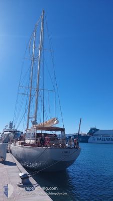
RHEA
Sailing

Current Trip
| Time Travelled | 12 days |
|---|---|
| Remaining Time | 14 h, 23 mins |
| Distance Travelled | 391.21 nm |
| Remaining Distance | 110.22 nm |
| AVG Speed | 6.6 Noeuds |
| MAX Speed | 11.4 Noeuds |
| AVG Wind | 14.2 knots |
| MAX Wind | 20.7 knots |
| MIN Temp | 25.1°C / 77.18°F |
| MAX Temp | 27.4°C / 81.32°F |
| Tirant d eau | 4.5 m |
| Position reçue | 2 m depuis |
Current Position
| Longitude | --- |
|---|---|
| Latitude | --- |
| Etat | At anchor |
| Vitesse | |
| Parcours | 72° |
| Zone | Caribbean Sea |
| Station | T-AIS |
| Position reçue | 2 m depuis |
Information
The current position of RHEA is in Caribbean Sea with coordinates 18.07734° / -63.09237° as reported on 2025-03-31 01:09 by AIS to our vessel tracker app. The vessel's current speed is 0 Noeuds and is heading at the port of FALMOUTH. The estimated time of arrival as calculated by MyShipTracking vessel tracking app is 2025-03-31 11:34 LT
The vessel RHEA (IMO: 982455200, MMSI: 244060297) is a Sailing It's sailing under the flag of [NL] Netherlands.
In this page you can find informations about the vessels current position, last detected port calls, and current voyage information. If the vessels is not in coverage by AIS you will find the latest position.
The current position of RHEA is detected by our AIS receivers and we are not responsible for the reliability of the data. The last position was recorded while the vessel was in Coverage by the Ais receivers of our vessel tracking app.
The current draught of RHEA as reported by AIS is 4.5 meters
Weather
| Temperature | 25.8°C / 78.44°F |
|---|---|
| Wind Speed | 20 knots |
| Direction | 78° ENE |
| Pressure | 1016.9 hPa |
| Humidity | 72.4 % |
| Cloud Coverage | --- |


Featured Company
Last Port Calls
| Port | Arrival | Departure | Time In Port |
|---|---|---|---|
| 2025-03-18 16:39 | 2025-03-18 19:14 | 2 h | |
| 2025-03-02 09:34 | 2025-03-02 09:42 | 8 m | |
| 2025-03-01 16:22 | 2025-03-01 16:48 | 26 m | |
| 2025-02-26 10:14 | |||
| 2025-02-18 17:11 | 2025-02-19 09:33 | 16 h | |
| 2025-02-17 09:29 | |||
| 2025-02-06 18:11 | 2025-02-07 11:08 | 16 h | |
| 2025-01-19 16:14 | 2025-01-20 09:49 | 17 h | |
| 2025-01-13 07:18 | 2025-01-13 07:28 | 9 m | |
| 2025-01-12 19:37 | 2025-01-13 06:39 | 11 h |
Most Visited Ports (Last year)
| Port | Arrivals | |
|---|---|---|
| 6 | ||
| 6 | ||
| 5 | ||
| 5 | ||
| 5 | ||
| 4 |
Last Trips
| Origin | Departure | Destination | Arrival | Distance | |
|---|---|---|---|---|---|
| 2025-03-02 09:42 | 2025-03-18 16:39 | 599.44 nm | |||
| 2025-03-01 16:48 | 2025-03-02 09:34 | 0.26 nm | |||
| 2025-02-26 10:14 | 2025-03-01 16:22 | 112.40 nm | |||
| 2025-02-17 09:29 | 2025-02-18 17:11 | 67.76 nm | |||
| 2025-01-20 09:49 | 2025-02-06 18:11 | 572.83 nm | |||
| 2025-01-13 07:28 | 2025-01-19 16:14 | 251.58 nm | |||
| 2025-01-13 06:39 | 2025-01-13 07:18 | 2.26 nm | |||
| 2025-01-12 15:29 | 2025-01-12 19:37 | 15.76 nm | |||
| 2025-01-09 09:32 | 2025-01-12 12:29 | 25.46 nm | |||
| 2025-01-04 09:48 | 2025-01-08 16:34 | 46.86 nm |
Events
| Heure | Evenement | Détails | Position/ Destination | Info |
|---|---|---|---|---|
| 2025-03-30 22:17 | Changement d'ETA | 2025/04/05 15:00 |
18.07720 / -63.09218
AG FAM
|
Vitesse: Parcours: 51° |
| 2025-03-30 20:57 | Etat Changé | At anchor Under way sailing |
18.07734 / -63.09217
AG FAM
|
Vitesse: 0.3 kn Parcours: 53° |
| 2025-03-30 20:44 | Arret | 0.9 nm, North of MARIGOT |
18.07759 / -63.09140
AG FAM
|
Vitesse: 0.3 kn Parcours: 68° |
| 2025-03-30 19:11 | Changement d'ETA | 2025/04/05 15:00 |
18.01440 / -63.19405
AG FAM
|
Vitesse: 7.6 kn Parcours: 9° |
| 2025-03-30 18:58 | Changement de zone | Saint-Martin part of the Caribbean Sea Sint-Maarten part of the Caribbean Sea |
17.98548 / -63.20109
Caribbean Sea
|
Vitesse: 8.7 kn Parcours: 14.1° |
| 2025-03-30 17:55 | Changement de zone | Sint-Maarten part of the Caribbean Sea Saba part of the Caribbean Sea |
17.86238 / -63.23228
Caribbean Sea
|
Vitesse: 6.6 kn Parcours: 7.5° |
| 2025-03-30 16:12 | Detecté en mer | Saba part of the Caribbean Sea |
17.65907 / -63.28273
Caribbean Sea
|
Vitesse: 7.9 kn Parcours: 14.5° |
| 2025-03-30 16:12 | Dans la zone couverte |
17.65907 / -63.28273
Caribbean Sea
|
Vitesse: 7.9 kn Parcours: 14.5° |
|
| 2025-03-27 18:00 | Hors de la zone couverte |
16.81837 / -62.21286
Caribbean Sea
|
Vitesse: 5.6 kn Parcours: 186.3° |
|
| 2025-03-27 16:01 | Changement de zone | Montserrat part of the Caribbean Sea Antigua and Barbuda part of the Caribbean Sea |
16.88002 / -62.00625
Caribbean Sea
|
Vitesse: 6.7 kn Parcours: 259° |