
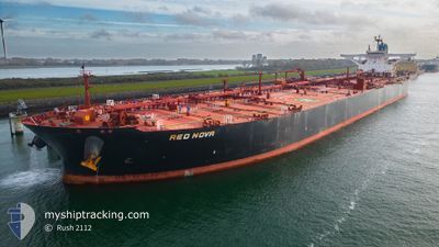
RED NOVA
Crude Oil Tanker
Current Trip
| Time Travelled | 20 days |
|---|---|
| Remaining Time | 1 day |
| Distance Travelled | 5124.05 nm |
| Remaining Distance | 482.69 nm |
| AVG Speed | 10.6 Noeuds |
| MAX Speed | 16.1 Noeuds |
| AVG Wind | 13.4 knots |
| MAX Wind | 27.8 knots |
| MIN Temp | 10°C / 50°F |
| MAX Temp | 29.4°C / 84.92°F |
| Tirant d eau | 11.2 m |
| Position reçue | 2 d depuis |
Current Position
| Longitude | -79.47447° |
|---|---|
| Latitude | 24.93828° |
| Etat | Under way using engine |
| Vitesse | 10.3 Noeuds |
| Parcours | 195.7° |
| Zone | North Atlantic Ocean |
| Station | T-AIS |
| Position reçue | 2 d depuis |
Info
Information
The current position of RED NOVA is in North Atlantic Ocean with coordinates 24.93828° / -79.47447° as reported on 2024-05-20 03:36 by AIS to our vessel tracker app. The vessel's current speed is 10.3 Noeuds and is heading at the port of HOUSTON. The estimated time of arrival as calculated by MyShipTracking vessel tracking app is 2024-05-23 22:59 LT
The vessel RED NOVA (IMO: 9602643, MMSI: 636019391) is a Crude Oil Tanker that was built in 2013 ( 11 Age ). It's sailing under the flag of [LR] Liberia.
In this page you can find informations about the vessels current position, last detected port calls, and current voyage information. If the vessels is not in coverage by AIS you will find the latest position.
The current position of RED NOVA is detected by our AIS receivers and we are not responsible for the reliability of the data. The last position was recorded while the vessel was in Coverage by the Ais receivers of our vessel tracking app.
The current draught of RED NOVA as reported by AIS is 11.2 meters
Weather
| Temperature | 27.2°C / 80.96°F |
|---|---|
| Wind Speed | 9 knots |
| Direction | 110° ESE |
| Pressure | 1012 hPa |
| Humidity | 84.6 % |
| Cloud Coverage | 3 % |
Featured Company
Last Trips
Events
| Heure | Evenement | Détails | Position/ Destination | Info |
|---|---|---|---|---|
| 2024-05-20 03:55 | Etat Changé | Default Under way using engine |
24.89026 / -79.49690
USHOU
|
Vitesse: 10.3 kn Parcours: 195.7° |
| 2024-05-20 03:36 | Hors de la zone couverte |
24.93828 / -79.47447
North Atlantic Ocean
USHOU
|
Vitesse: 10.3 kn Parcours: 195.7° |
|
| 2024-05-19 19:15 | Changement de destination | USHOU FOR ORDERS |
26.17365 / -79.23811
USHOU
|
Vitesse: 10 kn Parcours: 236.2° |
| 2024-05-19 19:15 | Changement d'ETA | 2024/05/24 16:00 2024/05/12 08:00 |
26.17365 / -79.23811
USHOU
|
Vitesse: 10 kn Parcours: 236.2° |
| 2024-05-19 18:57 | Etat Changé | Under way using engine Default |
26.19623 / -79.19157
FOR ORDERS
|
Vitesse: 10.5 kn Parcours: 256° |
| 2024-05-19 18:26 | Etat Changé | Default Under way using engine |
26.20911 / -79.09428
FOR ORDERS
|
Vitesse: 10.2 kn Parcours: 271.5° |
| 2024-05-19 18:21 | Etat Changé | Under way using engine Default |
26.20880 / -79.07745
FOR ORDERS
|
Vitesse: 10.2 kn Parcours: 272° |
| 2024-05-19 18:11 | Dans la zone couverte |
26.20884 / -79.07905
North Atlantic Ocean
|
Vitesse: 10.2 kn Parcours: 271.5° |
|
| 2024-05-19 14:38 | Etat Changé | Default Under way using engine |
26.09761 / -78.39509
FOR ORDERS
|
Vitesse: 10.1 kn Parcours: 285.8° |
| 2024-05-19 14:31 | Hors de la zone couverte |
26.09217 / -78.37373
North Atlantic Ocean
|
Vitesse: 10.1 kn Parcours: 285.8° |