

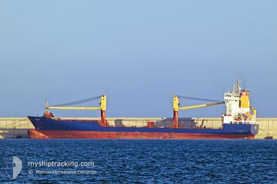
RAINER D
Container Ship

Current Trip
DOHAI
| Time Travelled | 2 days |
|---|---|
| Remaining Time | --- |
| Distance Travelled | 763.37 nm |
| Remaining Distance | --- |
| AVG Speed | 14.3 Noeuds |
| MAX Speed | 15.4 Noeuds |
| AVG Wind | 10.9 knots |
| MAX Wind | 18 knots |
| MIN Temp | 22.1°C / 71.78°F |
| MAX Temp | 26.7°C / 80.06°F |
| Tirant d eau | 6.1 m |
| Position reçue | 10 h, 44 m depuis |
Current Position
| Longitude | --- |
|---|---|
| Latitude | --- |
| Etat | Under way using engine |
| Vitesse | 14.9 Noeuds |
| Parcours | 314° |
| Zone | North Atlantic Ocean |
| Station | T-AIS |
| Position reçue | 10 h, 44 m depuis |
Information
The current position of RAINER D is in North Atlantic Ocean with coordinates 21.89359° / -77.11524° as reported on 2025-03-02 01:07 by AIS to our vessel tracker app. The vessel's current speed is 14.9 Noeuds
The vessel RAINER D (IMO: 9162679, MMSI: 636092880) is a Container Ship that was built in 1997 ( 28 Age ). It's sailing under the flag of [LR] Liberia.
In this page you can find informations about the vessels current position, last detected port calls, and current voyage information. If the vessels is not in coverage by AIS you will find the latest position.
The current position of RAINER D is detected by our AIS receivers and we are not responsible for the reliability of the data. The last position was recorded while the vessel was in Coverage by the Ais receivers of our vessel tracking app.
The current draught of RAINER D as reported by AIS is 6.1 meters
Weather
| Temperature | 24.3°C / 75.74°F |
|---|---|
| Wind Speed | 9 knots |
| Direction | 318° NW |
| Pressure | 1013.5 hPa |
| Humidity | 79.1 % |
| Cloud Coverage | --- |


Featured Company
Last Port Calls
| Port | Arrival | Departure | Time In Port |
|---|---|---|---|
| 2025-02-27 12:16 | 2025-02-28 04:42 | 16 h | |
| 2025-02-25 05:41 | 2025-02-25 23:19 | 17 h | |
| 2025-02-24 05:22 | 2025-02-24 21:37 | 16 h | |
| 2025-02-21 14:03 | 2025-02-22 04:48 | 14 h | |
| 2025-02-17 22:19 | 2025-02-18 08:43 | 10 h | |
| 2025-02-16 23:08 | 2025-02-17 08:24 | 9 h | |
| 2025-02-15 22:02 | 2025-02-16 08:20 | 10 h | |
| 2025-02-15 12:26 | |||
| 2025-02-15 12:05 | 2025-02-15 12:12 | 7 m | |
| 2025-02-12 18:30 | 2025-02-13 12:48 | 18 h |
Most Visited Ports (Last year)
| Port | Arrivals | |
|---|---|---|
| 51 | ||
| 40 | ||
| 26 | ||
| 21 | ||
| 8 | ||
| 4 |
Last Trips
| Origin | Departure | Destination | Arrival | Distance | |
|---|---|---|---|---|---|
| 2025-02-25 19:19 | 2025-02-27 08:16 | 490.31 nm | |||
| 2025-02-24 17:37 | 2025-02-25 01:41 | 66.69 nm | |||
| 2025-02-22 00:48 | 2025-02-24 01:22 | 508.41 nm | |||
| 2025-02-18 03:43 | 2025-02-21 10:03 | 961.31 nm | |||
| 2025-02-17 03:24 | 2025-02-17 17:19 | 9.93 nm | |||
| 2025-02-16 03:20 | 2025-02-16 18:08 | 10.41 nm | |||
| 2025-02-15 07:12 | 2025-02-15 17:02 | 1.97 nm | |||
| 2025-02-15 07:12 | 2025-02-15 07:26 | 0.81 nm | |||
| 2025-02-13 07:48 | 2025-02-15 07:05 | 632.45 nm | |||
| 2025-02-11 22:11 | 2025-02-12 13:30 | 182.59 nm |
Events
| Heure | Evenement | Détails | Position/ Destination | Info |
|---|---|---|---|---|
| 2025-03-02 01:15 | Etat Changé | Default Under way using engine |
21.91747 / -77.14225
DOHAI
|
Vitesse: 14.9 kn Parcours: 314° |
| 2025-03-02 01:07 | Detecté en mer | Cuban part of the North Atlantic Ocean |
21.89359 / -77.11524
North Atlantic Ocean
|
Vitesse: 14.9 kn Parcours: 314° |
| 2025-03-02 01:07 | Etat Changé | Under way using engine Default |
21.89359 / -77.11524
DOHAI
|
Vitesse: 15 kn Parcours: 308° |
| 2025-03-02 01:07 | Dans la zone couverte |
21.89359 / -77.11524
North Atlantic Ocean
|
Vitesse: 14.9 kn Parcours: 314° |
|
| 2025-03-02 01:07 | Hors de la zone couverte |
21.89359 / -77.11524
North Atlantic Ocean
|
Vitesse: 14.9 kn Parcours: 314° |
|
| 2025-02-28 05:26 | Etat Changé | Default Under way using engine |
18.26457 / -70.03728
DOHAI
|
Vitesse: 13.8 kn Parcours: 189.8° |
| 2025-02-28 05:18 | Hors de la zone couverte |
18.29498 / -70.03137
Caribbean Sea
|
Vitesse: 13.8 kn Parcours: 189.8° |
|
| 2025-02-28 04:54 | Etat Changé | Under way using engine Moored |
18.38540 / -70.01409
DOHAI
|
Vitesse: 10.6 kn Parcours: 170° |
| 2025-02-28 04:50 | Etat Changé | Moored Default |
18.39755 / -70.01533
DOHAI
|
Vitesse: Parcours: 312° |
| 2025-02-28 04:50 | Démarrage | 1.28 nm, South of RIO HAINA |
18.39755 / -70.01533
DOHAI
|
Vitesse: 10.6 kn Parcours: 170° |