
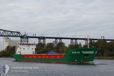
PINTA
General Cargo
Current Trip
| Time Travelled | 1 day |
|---|---|
| Remaining Time | 23 h, 11 mins |
| Distance Travelled | 301.88 nm |
| Remaining Distance | 225.32 nm |
| AVG Speed | 8.2 Noeuds |
| MAX Speed | 9.4 Noeuds |
| AVG Wind | 10.1 knots |
| MAX Wind | 17.7 knots |
| MIN Temp | 2.9°C / 37.22°F |
| MAX Temp | 6.9°C / 44.42°F |
| Tirant d eau | 5.1 m |
| Position reçue | 15 h, 24 m depuis |
Current Position
| Longitude | --- |
|---|---|
| Latitude | --- |
| Etat | Under way using engine |
| Vitesse | 8 Noeuds |
| Parcours | 252.7° |
| Zone | North Sea |
| Station | T-AIS |
| Position reçue | 15 h, 24 m depuis |
Info
Information
The current position of PINTA is in North Sea with coordinates 57.19485° / 5.87003° as reported on 2025-02-26 08:30 by AIS to our vessel tracker app. The vessel's current speed is 8 Noeuds and is heading at the port of METHIL. The estimated time of arrival as calculated by MyShipTracking vessel tracking app is 2025-02-27 23:06 LT
The vessel PINTA (IMO: 9063299, MMSI: 236180000) is a General Cargo that was built in 1993 ( 32 Age ). It's sailing under the flag of [GI] Gibraltar.
In this page you can find informations about the vessels current position, last detected port calls, and current voyage information. If the vessels is not in coverage by AIS you will find the latest position.
The current position of PINTA is detected by our AIS receivers and we are not responsible for the reliability of the data. The last position was recorded while the vessel was in Coverage by the Ais receivers of our vessel tracking app.
The current draught of PINTA as reported by AIS is 5.1 meters
Weather
| Temperature | 5.5°C / 41.9°F |
|---|---|
| Wind Speed | 13 knots |
| Direction | 116° ESE |
| Pressure | 1010 hPa |
| Humidity | 90.4 % |
| Cloud Coverage | 100 % |
Featured Company
Last Port Calls
| Port | Arrival | Departure | Time In Port |
|---|---|---|---|
| 2025-02-23 10:50 | 2025-02-25 04:46 | 1 d | |
| 2025-02-17 18:25 | 2025-02-18 23:32 | 1 d | |
| 2025-02-14 22:04 | 2025-02-17 04:32 | 2 d | |
| 2025-02-13 02:32 | 2025-02-14 15:08 | 1 d | |
| 2025-02-04 10:16 | 2025-02-06 08:54 | 1 d | |
| 2025-02-01 09:52 | 2025-02-03 15:39 | 2 d | |
| 2025-01-30 01:28 | 2025-01-30 14:05 | 12 h | |
| 2025-01-27 00:04 | 2025-01-28 01:01 | 1 d | |
| 2025-01-23 08:17 | 2025-01-23 21:24 | 13 h | |
| 2025-01-18 01:21 | 2025-01-20 18:35 | 2 d |
Last Trips
| Origin | Departure | Destination | Arrival | Distance | |
|---|---|---|---|---|---|
| 2025-02-18 23:32 | 2025-02-23 10:50 | 547.07 nm | |||
| 2025-02-17 04:32 | 2025-02-17 18:25 | 105.44 nm | |||
| 2025-02-14 15:08 | 2025-02-14 22:04 | 48.83 nm | |||
| 2025-02-06 08:54 | 2025-02-13 02:32 | 541.03 nm | |||
| 2025-02-03 15:39 | 2025-02-04 10:16 | 146.36 nm | |||
| 2025-01-30 14:05 | 2025-02-01 09:52 | 364.18 nm | |||
| 2025-01-28 01:01 | 2025-01-30 01:28 | 338.64 nm | |||
| 2025-01-23 21:24 | 2025-01-27 00:04 | 10.46 nm | |||
| 2025-01-20 18:35 | 2025-01-23 08:17 | 534.82 nm | |||
| 2025-01-10 09:06 | 2025-01-18 01:21 | 1218.81 nm |
Events
| Heure | Evenement | Détails | Position/ Destination | Info |
|---|---|---|---|---|
| 2025-02-26 08:39 | Etat Changé | Default Under way using engine |
57.18894 / 5.83568
GBMTH
|
Vitesse: 8 kn Parcours: 252.7° |
| 2025-02-26 08:30 | Etat Changé | Under way using engine Default |
57.19485 / 5.87003
GBMTH
|
Vitesse: 8.1 kn Parcours: 252° |
| 2025-02-26 08:30 | Hors de la zone couverte |
57.19485 / 5.87003
North Sea
GBMTH
|
Vitesse: 8 kn Parcours: 252.7° |
|
| 2025-02-26 08:09 | Etat Changé | Default Under way using engine |
57.20905 / 5.95289
GBMTH
|
Vitesse: 7.9 kn Parcours: 254.9° |
| 2025-02-25 23:38 | Changement de zone | Norwegian part of the North Sea Norwegian part of the Skaggerak |
57.51798 / 7.87512
North Sea
GBMTH
|
Vitesse: 8.1 kn Parcours: 251.6° |
| 2025-02-25 22:02 | Detecté en mer | Norwegian part of the Skaggerak |
57.57310 / 8.27654
Skaggerak
GBMTH
|
Vitesse: 8.5 kn Parcours: 256.2° |
| 2025-02-25 10:46 | Changement de zone | Danish part of the Skaggerak Danish part of the Kattegat |
57.80470 / 10.96353
Skaggerak
GBMTH
|
Vitesse: 8.7 kn Parcours: 314.9° |
| 2025-02-25 09:46 | Changement de zone | Danish part of the Kattegat Swedish part of the Kattegat |
57.69593 / 11.16283
Kattegat
GBMTH
|
Vitesse: 9.3 kn Parcours: 320° |
| 2025-02-25 03:46 | PORT DE DEPART |
|
57.10648 / 12.23119
GBMTH
|
Vitesse: 4.6 kn Parcours: 196° |
| 2025-02-25 03:40 | Démarrage |
57.11438 / 12.23572
[SE] VARBERG
|
Vitesse: 3.1 kn Parcours: 183° |