

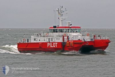
PILOTTENDER BORKUM
Pilot Vessel

Current Trip
| Trip Time | 4 h, 6 mins |
|---|---|
| Trip Distance | 30.53 nm |
| AVG Speed | 8.3 Noeuds |
| MAX Speed | 13.6 Noeuds |
| Tirant d eau | 3.1 m |
| AVG Wind | 10.6 knots |
| MAX Wind | 14 knots |
| MIN Temp | 4.2°C / 39.56°F |
| MAX Temp | 4.9°C / 40.82°F |
| Position reçue | 3 m depuis |
Current Position
| Longitude | --- |
|---|---|
| Latitude | --- |
| Etat | Under way using engine |
| Vitesse | |
| Parcours | 2° |
| Zone | North Sea |
| Station | T-AIS |
| Position reçue | 3 m depuis |
Information
The current position of PILOTTENDER BORKUM is in North Sea with coordinates 53.56239° / 6.74903° as reported on 2025-03-18 08:35 by AIS to our vessel tracker app. The vessel's current speed is 0 Noeuds and is currently inside the port of BORKUM.
The vessel PILOTTENDER BORKUM (MMSI: 211181900) is a Pilot Vessel It's sailing under the flag of [DE] Germany.
In this page you can find informations about the vessels current position, last detected port calls, and current voyage information. If the vessels is not in coverage by AIS you will find the latest position.
The current position of PILOTTENDER BORKUM is detected by our AIS receivers and we are not responsible for the reliability of the data. The last position was recorded while the vessel was in Coverage by the Ais receivers of our vessel tracking app.
The current draught of PILOTTENDER BORKUM as reported by AIS is 3.1 meters
Weather
| Temperature | 3.1°C / 37.58°F |
|---|---|
| Wind Speed | 6 knots |
| Direction | 139° SE |
| Pressure | 1032 hPa |
| Humidity | 53.5 % |
| Cloud Coverage | --- |


Featured Company
Last Port Calls
| Port | Arrival | Departure | Time In Port |
|---|---|---|---|
| 2025-03-11 23:34 | |||
| 2025-02-16 10:59 | 2025-03-11 19:28 | 23 d | |
| 2025-02-11 19:34 | 2025-02-16 10:43 | 4 d | |
| 2025-02-11 09:12 | 2025-02-11 19:22 | 10 h | |
| 2025-02-10 22:42 | 2025-02-11 08:57 | 10 h | |
| 2025-02-10 19:17 | 2025-02-10 20:13 | 56 m | |
| 2025-02-10 08:18 | 2025-02-10 16:51 | 8 h | |
| 2025-02-10 03:46 | 2025-02-10 05:45 | 1 h | |
| 2025-02-08 09:43 | 2025-02-10 01:40 | 1 d | |
| 2025-02-08 04:36 | 2025-02-08 07:19 | 2 h |
Last Trips
| Origin | Departure | Destination | Arrival | Distance | |
|---|---|---|---|---|---|
| 2025-03-11 19:28 | 2025-03-11 23:34 | 30.53 nm | |||
| 2025-02-16 10:43 | 2025-02-16 10:59 | 2.00 nm | |||
| 2025-02-11 19:22 | 2025-02-11 19:34 | 1.57 nm | |||
| 2025-02-11 08:57 | 2025-02-11 09:12 | 1.74 nm | |||
| 2025-02-10 20:13 | 2025-02-10 22:42 | 2.42 nm | |||
| 2025-02-10 16:51 | 2025-02-10 19:17 | 2.59 nm | |||
| 2025-02-10 05:45 | 2025-02-10 08:18 | 3.29 nm | |||
| 2025-02-10 01:40 | 2025-02-10 03:46 | 2.25 nm | |||
| 2025-02-08 07:19 | 2025-02-08 09:43 | 2.13 nm | |||
| 2025-02-08 02:21 | 2025-02-08 04:36 | 2.25 nm |
Events
| Heure | Evenement | Détails | Position/ Destination | Info |
|---|---|---|---|---|
| 2025-03-17 13:38 | Dans la zone couverte |
53.56238 / 6.74904
North Sea
[DE] BORKUM
|
Vitesse: Parcours: 324.4° |
|
| 2025-03-17 07:37 | Hors de la zone couverte |
53.56239 / 6.74898
North Sea
[DE] BORKUM
|
Vitesse: 0.4 kn Parcours: 277.2° |
|
| 2025-03-15 14:16 | Dans la zone couverte |
53.56237 / 6.74903
North Sea
[DE] BORKUM
|
Vitesse: Parcours: 125° |
|
| 2025-03-15 12:14 | Hors de la zone couverte |
53.56238 / 6.74903
North Sea
[DE] BORKUM
|
Vitesse: Parcours: 238° |
|
| 2025-03-11 22:40 | Arret |
53.56237 / 6.74905
[DE] BORKUM
|
Vitesse: 0.1 kn Parcours: 0° |
|
| 2025-03-11 22:34 | Port d'arrivée |
|
53.55794 / 6.74983
[DE] BORKUM
|
Vitesse: 13.6 kn Parcours: 80.1° |
| 2025-03-11 22:27 | Detecté en mer | German part of the North Sea |
53.55163 / 6.71317
North Sea
|
Vitesse: 13.6 kn Parcours: 80.1° |
| 2025-03-11 21:27 | Dans la zone couverte |
53.62534 / 6.40460
North Sea
|
Vitesse: 8.9 kn Parcours: 287.6° |
|
| 2025-03-11 19:36 | Hors de la zone couverte |
53.62675 / 6.32521
North Sea
|
Vitesse: 8.4 kn Parcours: 132.7° |
|
| 2025-03-11 19:36 | Detecté en mer | Dutch part of the North Sea |
53.62675 / 6.32521
North Sea
|
Vitesse: 8.4 kn Parcours: 132.7° |