

PICK UP
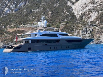
Pleasure Craft

Current Trip
SAFE HARBOUR MARINA
| Trip Time | 33 mins |
|---|---|
| Trip Distance | 1.96 nm |
| AVG Speed | 3.4 Noeuds |
| MAX Speed | 4.2 Noeuds |
| Tirant d eau | 3.2 m |
| AVG Wind | 9.7 knots |
| MAX Wind | 10 knots |
| MIN Temp | 22.7°C / 72.86°F |
| MAX Temp | 24°C / 75.2°F |
| Position reçue | 4 m depuis |
Current Position
| Longitude | --- |
|---|---|
| Latitude | --- |
| Etat | Moored |
| Vitesse | |
| Parcours | 359° |
| Zone | North Atlantic Ocean |
| Station | T-AIS |
| Position reçue | 4 m depuis |
Information
The current position of PICK UP is in North Atlantic Ocean with coordinates 26.09571° / -80.16657° as reported on 2025-03-30 08:11 by AIS to our vessel tracker app. The vessel's current speed is 0 Noeuds and is currently inside the port of FORT LAUDERDALE.
The vessel PICK UP (IMO: 8679778, MMSI: 319081800) is a Pleasure Craft It's sailing under the flag of [KY] Cayman Is.
In this page you can find informations about the vessels current position, last detected port calls, and current voyage information. If the vessels is not in coverage by AIS you will find the latest position.
The current position of PICK UP is detected by our AIS receivers and we are not responsible for the reliability of the data. The last position was recorded while the vessel was in Coverage by the Ais receivers of our vessel tracking app.
The current draught of PICK UP as reported by AIS is 3.2 meters
Weather
| Temperature | 23.9°C / 75.02°F |
|---|---|
| Wind Speed | 13 knots |
| Direction | 122° ESE |
| Pressure | 1017.2 hPa |
| Humidity | 79.7 % |
| Cloud Coverage | 14 % |


Featured Company
Last Port Calls
| Port | Arrival | Departure | Time In Port |
|---|---|---|---|
| 2025-02-20 18:35 | |||
| 2025-02-19 13:23 | 2025-02-20 18:02 | 1 d | |
| 2025-02-15 18:00 | 2025-02-18 17:19 | 2 d | |
| 2025-01-18 15:13 | 2025-01-28 19:43 | 10 d | |
| 2025-01-14 20:49 | 2025-01-16 12:58 | 1 d | |
| 2025-01-12 13:38 | 2025-01-14 12:51 | 1 d | |
| 2025-01-06 16:28 | 2025-01-09 14:21 | 2 d | |
| 2025-01-05 12:52 | 2025-01-06 11:08 | 22 h |
Last Trips
| Origin | Departure | Destination | Arrival | Distance | |
|---|---|---|---|---|---|
| 2025-02-20 13:02 | 2025-02-20 13:35 | 1.96 nm | |||
| 2025-02-18 12:19 | 2025-02-19 08:23 | 165.11 nm | |||
| 2025-01-28 15:43 | 2025-02-15 13:00 | 1053.82 nm | |||
| 2025-01-16 08:58 | 2025-01-18 11:13 | 18.40 nm | |||
| 2025-01-14 08:51 | 2025-01-14 16:49 | 104.23 nm | |||
| 2025-01-09 10:21 | 2025-01-12 09:38 | 185.73 nm | |||
| 2025-01-06 07:08 | 2025-01-06 12:28 | 25.39 nm | |||
| 2024-12-28 07:45 | 2025-01-05 08:52 | 159.74 nm |
Events
| Heure | Evenement | Détails | Position/ Destination | Info |
|---|---|---|---|---|
| 2025-03-26 10:21 | Tirant d'eau modifié | 3.2 3.4 |
26.09566 / -80.16653
[US] FORT LAUDERDALE
|
Vitesse: Parcours: 359° |
| 2025-03-26 10:21 | Changement de destination | SAFE HARBOUR MARINA 3AFE KARBOUR*MBRILA |
26.09566 / -80.16653
[US] FORT LAUDERDALE
|
Vitesse: Parcours: 359° |
| 2025-03-26 08:51 | Tirant d'eau modifié | 3.4 3.2 |
26.09565 / -80.16653
[US] FORT LAUDERDALE
|
Vitesse: Parcours: 359° |
| 2025-03-26 08:51 | Changement de destination | 3AFE KARBOUR*MBRILA SAFE HARBOUR MARINA |
26.09565 / -80.16653
[US] FORT LAUDERDALE
|
Vitesse: Parcours: 359° |