
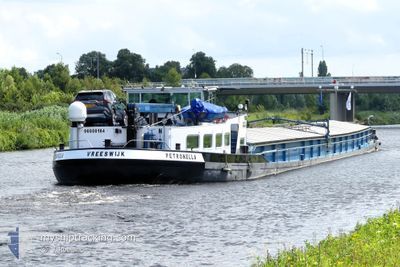
PETRONELLA
Cargo
Current Trip
| Time Travelled | 11 days |
|---|---|
| Remaining Time | --- |
| Distance Travelled | 137.12 nm |
| Remaining Distance | --- |
| AVG Speed | 6.5 Noeuds |
| MAX Speed | 7 Noeuds |
| AVG Wind | 4 knots |
| MAX Wind | 6 knots |
| MIN Temp | -2.3°C / 27.86°F |
| MAX Temp | 7.2°C / 44.96°F |
| Tirant d eau | 2.5 m |
| Position reçue | 1 d depuis |
Current Position
| Longitude | --- |
|---|---|
| Latitude | --- |
| Etat | Under way using engine |
| Vitesse | 6.5 Noeuds |
| Parcours | 116.8° |
| Zone | North Sea |
| Station | T-AIS |
| Position reçue | 1 d depuis |
Info
Information
The current position of PETRONELLA is in North Sea with coordinates 52.40781° / 9.73933° as reported on 2025-02-14 18:26 by AIS to our vessel tracker app. The vessel's current speed is 6.5 Noeuds
The vessel PETRONELLA (MMSI: 244000642) is a Cargo It's sailing under the flag of [NL] Netherlands.
In this page you can find informations about the vessels current position, last detected port calls, and current voyage information. If the vessels is not in coverage by AIS you will find the latest position.
The current position of PETRONELLA is detected by our AIS receivers and we are not responsible for the reliability of the data. The last position was recorded while the vessel was in Coverage by the Ais receivers of our vessel tracking app.
The current draught of PETRONELLA as reported by AIS is 2.5 meters
Weather
| Temperature | 0.1°C / 32.18°F |
|---|---|
| Wind Speed | 1 knots |
| Direction | 329° NNW |
| Pressure | 1028.5 hPa |
| Humidity | 84.3 % |
| Cloud Coverage | 99 % |
Featured Company
Last Port Calls
| Port | Arrival | Departure | Time In Port |
|---|---|---|---|
| 2025-02-04 09:23 | 2025-02-05 10:06 | 1 d | |
| 2025-02-03 15:54 | 2025-02-03 16:46 | 51 m | |
| 2025-01-28 19:40 | 2025-01-29 06:43 | 11 h | |
| 2025-01-27 19:30 | 2025-01-28 06:16 | 10 h | |
| 2025-01-21 05:55 | |||
| 2025-01-17 11:34 | 2025-01-17 12:50 | 1 h | |
| 2025-01-15 16:35 | 2025-01-15 17:08 | 32 m | |
| 2025-01-15 11:31 | 2025-01-15 12:03 | 32 m | |
| 2025-01-14 22:06 | 2025-01-15 07:54 | 9 h | |
| 2025-01-12 21:13 | 2025-01-13 07:18 | 10 h |
Most Visited Ports (Last year)
| Port | Arrivals | |
|---|---|---|
| 16 | ||
| 9 | ||
| 9 | ||
| 8 | ||
| 7 | ||
| 7 |
Last Trips
| Origin | Departure | Destination | Arrival | Distance | |
|---|---|---|---|---|---|
| 2025-02-03 16:46 | 2025-02-04 09:23 | 4.89 nm | |||
| 2025-01-29 06:43 | 2025-02-03 15:54 | 80.21 nm | |||
| 2025-01-28 06:16 | 2025-01-28 19:40 | 43.33 nm | |||
| 2025-01-21 05:55 | 2025-01-27 19:30 | 286.63 nm | |||
| 2025-01-15 17:08 | 2025-01-17 11:34 | 68.86 nm | |||
| 2025-01-15 12:03 | 2025-01-15 16:35 | 30.89 nm | |||
| 2025-01-15 07:54 | 2025-01-15 11:31 | 32.31 nm | |||
| 2025-01-13 07:18 | 2025-01-14 22:06 | 65.03 nm | |||
| 2025-01-12 17:50 | 2025-01-12 21:13 | 22.53 nm | |||
| 2025-01-12 08:58 | 2025-01-12 17:10 | 83.96 nm |
Events
| Heure | Evenement | Détails | Position/ Destination | Info |
|---|---|---|---|---|
| 2025-02-14 18:26 | Hors de la zone couverte |
52.40781 / 9.73933
North Sea
VAHLDORF
|
Vitesse: 6.5 kn Parcours: 116.8° |
|
| 2025-02-14 18:14 | Dans la zone couverte |
52.41675 / 9.71307
North Sea
VAHLDORF
|
Vitesse: 6.8 kn Parcours: 119.3° |
|
| 2025-02-14 16:56 | Hors de la zone couverte |
52.40697 / 9.49050
North Sea
VAHLDORF
|
Vitesse: 6.8 kn Parcours: 68.3° |
|
| 2025-02-14 16:56 | Etat Changé | Under way using engine Default |
52.40697 / 9.49050
VAHLDORF
|
Vitesse: 4.9 kn Parcours: -1° |
| 2025-02-14 16:47 | Etat Changé | Default Under way using engine |
52.40064 / 9.46446
VAHLDORF
|
Vitesse: 6.6 kn Parcours: 68.7° |
| 2025-02-14 15:53 | Dans la zone couverte |
52.38718 / 9.31001
North Sea
VAHLDORF
|
Vitesse: 6.6 kn Parcours: 83.9° |
|
| 2025-02-14 14:10 | Hors de la zone couverte |
52.30931 / 9.04957
North Sea
VAHLDORF
|
Vitesse: 6.6 kn Parcours: 53.9° |
|
| 2025-02-14 13:21 | Dans la zone couverte |
52.30254 / 8.92226
North Sea
VAHLDORF
|
Vitesse: 6.9 kn Parcours: 77.7° |
|
| 2025-02-14 09:02 | Hors de la zone couverte |
52.38039 / 8.21299
North Sea
VAHLDORF
|
Vitesse: 6.6 kn Parcours: 132.9° |
|
| 2025-02-14 07:07 | Tirant d'eau modifié | 2.5 2.7 |
52.37960 / 7.90190
VAHLDORF
|
Vitesse: 6.6 kn Parcours: 82.3° |