

PATRICK C
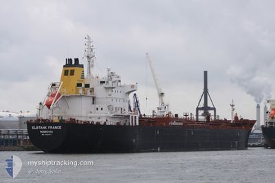
Oil/Chemical Tanker

Current Trip
JM PEV
| Time Travelled | 2 days |
|---|---|
| Remaining Time | --- |
| Distance Travelled | 172.10 nm |
| Remaining Distance | --- |
| AVG Speed | 10.3 Noeuds |
| MAX Speed | 11.7 Noeuds |
| AVG Wind | 10.8 knots |
| MAX Wind | 18 knots |
| MIN Temp | 26.1°C / 78.98°F |
| MAX Temp | 31.8°C / 89.24°F |
| Tirant d eau | 11 m |
| Position reçue | 10 d depuis |
Current Position
| Longitude | --- |
|---|---|
| Latitude | --- |
| Etat | Under way using engine |
| Vitesse | 10.2 Noeuds |
| Parcours | 239.5° |
| Zone | Caribbean Sea |
| Station | T-AIS |
| Position reçue | 10 d depuis |
Information
The current position of PATRICK C is in Caribbean Sea with coordinates 17.48654° / -63.04644° as reported on 2025-02-22 20:53 by AIS to our vessel tracker app. The vessel's current speed is 10.2 Noeuds
The vessel PATRICK C (IMO: 9425497, MMSI: 636016315) is a Oil/Chemical Tanker that was built in 2009 ( 16 Age ). It's sailing under the flag of [LR] Liberia.
In this page you can find informations about the vessels current position, last detected port calls, and current voyage information. If the vessels is not in coverage by AIS you will find the latest position.
The current position of PATRICK C is detected by our AIS receivers and we are not responsible for the reliability of the data. The last position was recorded while the vessel was in Coverage by the Ais receivers of our vessel tracking app.
The current draught of PATRICK C as reported by AIS is 11 meters
Weather
| Temperature | 27.2°C / 80.96°F |
|---|---|
| Wind Speed | 11 knots |
| Direction | 84° E |
| Pressure | 1012.2 hPa |
| Humidity | 67.6 % |
| Cloud Coverage | --- |


Featured Company
Last Port Calls
| Port | Arrival | Departure | Time In Port |
|---|---|---|---|
| 2025-02-28 14:31 | 2025-03-02 17:15 | 2 d | |
| 2025-02-20 17:39 | 2025-02-22 20:37 | 2 d | |
| 2025-01-30 17:14 | 2025-01-31 17:39 | 1 d | |
| 2025-01-06 00:51 | 2025-01-09 12:58 | 3 d | |
| 2025-01-01 01:09 | 2025-01-01 01:42 | 32 m |
Most Visited Ports (Last year)
| Port | Arrivals | |
|---|---|---|
| 3 | ||
| 3 | ||
| 2 | ||
| 2 | ||
| 2 | ||
| 1 |
Last Trips
| Origin | Departure | Destination | Arrival | Distance | |
|---|---|---|---|---|---|
| 2025-02-22 16:37 | 2025-02-28 09:31 | 860.26 nm | |||
| 2025-01-31 12:39 | 2025-02-20 13:39 | 3031.89 nm | |||
| 2025-01-09 06:58 | 2025-01-30 12:14 | 3728.53 nm | |||
| 2024-12-31 19:42 | 2025-01-05 18:51 | 312.46 nm | |||
| 2024-12-09 05:04 | 2024-12-31 19:09 | 2718.14 nm |
Events
| Heure | Evenement | Détails | Position/ Destination | Info |
|---|---|---|---|---|
| 2025-03-04 22:30 | Arret |
17.10972 / -76.55385
JM PEV
|
Vitesse: 0.3 kn Parcours: 167° |
|
| 2025-03-02 17:15 | PORT DE DEPART |
|
17.88333 / -77.12337
JM PEV
|
Vitesse: 4.8 kn Parcours: 134° |
| 2025-03-02 17:12 | Démarrage |
17.88729 / -77.12922
[JM] ESQUIVEL
|
Vitesse: 4.8 kn Parcours: 134° |
|
| 2025-02-28 14:51 | Arret |
17.89014 / -77.13109
[JM] ESQUIVEL
|
Vitesse: Parcours: 145° |
|
| 2025-02-28 14:31 | Port d'arrivée |
|
17.88810 / -77.13071
[JM] ESQUIVEL
|
Vitesse: 2 kn Parcours: 325° |
| 2025-02-28 13:36 | Démarrage | 2.49 nm, South East of ESQUIVEL |
17.86644 / -77.09386
JM PEV
|
Vitesse: 3.7 kn Parcours: 304° |
| 2025-02-25 14:27 | Arret | 2.94 nm, South East of ESQUIVEL |
17.86072 / -77.08836
JM PEV
|
Vitesse: 0.3 kn Parcours: 290° |