
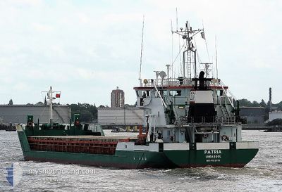
PATRIA
General Cargo
Current Trip
| Time Travelled | 3 h, 35 mins |
|---|---|
| Remaining Time | --- |
| Distance Travelled | 23.13 nm |
| Remaining Distance | --- |
| AVG Speed | 6.9 Noeuds |
| MAX Speed | 7.6 Noeuds |
| AVG Wind | 9.3 knots |
| MAX Wind | 11 knots |
| MIN Temp | 4.1°C / 39.38°F |
| MAX Temp | 6.2°C / 43.16°F |
| Tirant d eau | 5.8 m |
| Position reçue | 1 m depuis |
Current Position
| Longitude | --- |
|---|---|
| Latitude | --- |
| Etat | Under way using engine |
| Vitesse | 6.6 Noeuds |
| Parcours | 213.5° |
| Zone | Baltic Sea |
| Station | T-AIS |
| Position reçue | 1 m depuis |
Information
The current position of PATRIA is in Baltic Sea with coordinates 54.22250° / 9.59752° as reported on 2025-03-26 05:15 by AIS to our vessel tracker app. The vessel's current speed is 6.6 Noeuds and is heading at the port of SHARPNESS. The estimated time of arrival as calculated by MyShipTracking vessel tracking app is 2025-03-30 06:00 LT
The vessel PATRIA (IMO: 9123312, MMSI: 209734000) is a General Cargo that was built in 1995 ( 30 Age ). It's sailing under the flag of [CY] Cyprus.
In this page you can find informations about the vessels current position, last detected port calls, and current voyage information. If the vessels is not in coverage by AIS you will find the latest position.
The current position of PATRIA is detected by our AIS receivers and we are not responsible for the reliability of the data. The last position was recorded while the vessel was in Coverage by the Ais receivers of our vessel tracking app.
The current draught of PATRIA as reported by AIS is 5.8 meters
Weather
| Temperature | 6.3°C / 43.34°F |
|---|---|
| Wind Speed | 7 knots |
| Direction | 313° NW |
| Pressure | 1018.2 hPa |
| Humidity | 83 % |
| Cloud Coverage | 86 % |
Featured Company
Last Port Calls
| Port | Arrival | Departure | Time In Port |
|---|---|---|---|
| 2025-03-26 00:59 | 2025-03-26 01:42 | 42 m | |
| 2025-03-23 09:38 | 2025-03-24 04:54 | 19 h | |
| 2025-03-18 04:10 | 2025-03-19 11:45 | 1 d | |
| 2025-03-12 13:29 | 2025-03-13 18:35 | 1 d | |
| 2025-03-10 15:44 | 2025-03-11 10:45 | 19 h | |
| 2025-02-25 06:08 | 2025-03-01 13:57 | 4 d | |
| 2025-02-18 17:22 | 2025-02-19 20:50 | 1 d | |
| 2025-02-14 07:33 | 2025-02-15 14:33 | 1 d | |
| 2025-02-11 13:33 | 2025-02-12 04:05 | 14 h | |
| 2025-01-31 05:50 | 2025-02-04 09:45 | 4 d |
Most Visited Ports (Last year)
| Port | Arrivals | |
|---|---|---|
| 5 | ||
| 4 | ||
| 4 | ||
| 3 | ||
| 3 | ||
| 3 |
Last Trips
| Origin | Departure | Destination | Arrival | Distance | |
|---|---|---|---|---|---|
| 2025-03-24 06:54 | 2025-03-26 01:59 | 414.77 nm | |||
| 2025-03-19 12:45 | 2025-03-23 11:38 | 569.43 nm | |||
| 2025-03-13 19:35 | 2025-03-18 05:10 | 896.70 nm | |||
| 2025-03-11 11:45 | 2025-03-12 14:29 | 266.31 nm | |||
| 2025-03-01 14:57 | 2025-03-10 16:44 | 2003.45 nm | |||
| 2025-02-19 21:50 | 2025-02-25 07:08 | 1000.41 nm | |||
| 2025-02-15 15:33 | 2025-02-18 18:22 | 687.92 nm | |||
| 2025-02-12 05:05 | 2025-02-14 08:33 | 254.19 nm | |||
| 2025-02-04 11:45 | 2025-02-11 14:33 | 908.61 nm | |||
| 2025-01-27 23:21 | 2025-01-31 07:50 | 608.74 nm |
Events
| Heure | Evenement | Détails | Position/ Destination | Info |
|---|---|---|---|---|
| 2025-03-26 01:42 | PORT DE DEPART |
|
54.36658 / 10.13573
SHARPNESS VIA NOK
|
Vitesse: 5.7 kn Parcours: 297° |
| 2025-03-26 01:40 | Démarrage |
54.36573 / 10.14023
[DE] KIEL
|
Vitesse: 3.7 kn Parcours: 284° |
|
| 2025-03-26 01:15 | Arret |
54.36519 / 10.14323
[DE] KIEL
|
Vitesse: 0.3 kn Parcours: 285° |
|
| 2025-03-26 00:59 | Port d'arrivée |
|
54.36278 / 10.16719
[DE] KIEL
|
Vitesse: 7 kn Parcours: 232.9° |
| 2025-03-26 00:48 | Démarrage | 0.53 nm, North West of MOELTENORT |
54.37996 / 10.18253
SHARPNESS VIA NOK
|
Vitesse: 3.1 kn Parcours: 217° |
| 2025-03-26 00:07 | Arret | 0.52 nm, North West of MOELTENORT |
54.38184 / 10.18541
SHARPNESS VIA NOK
|
Vitesse: 0.3 kn Parcours: 225° |
| 2025-03-25 21:55 | Changement de zone | German part of the Baltic Sea Danish part of the Baltic Sea |
54.56324 / 10.56157
Baltic Sea
SHARPNESS VIA NOK
|
Vitesse: 9.9 kn Parcours: 249.2° |
| 2025-03-25 21:01 | Detecté en mer | Danish part of the Baltic Sea |
54.58582 / 10.80886
Baltic Sea
SHARPNESS VIA NOK
|
Vitesse: 9.5 kn Parcours: 263.9° |
| 2025-03-25 18:58 | Changement de zone | German part of the Baltic Sea Danish part of the Baltic Sea |
54.54866 / 11.35691
Baltic Sea
SHARPNESS VIA NOK
|
Vitesse: 9.7 kn Parcours: 297.3° |
| 2025-03-25 12:13 | Changement de zone | Danish part of the Baltic Sea German part of the Baltic Sea |
54.78966 / 12.80735
Baltic Sea
SHARPNESS VIA NOK
|
Vitesse: 9.1 kn Parcours: 270.9° |