
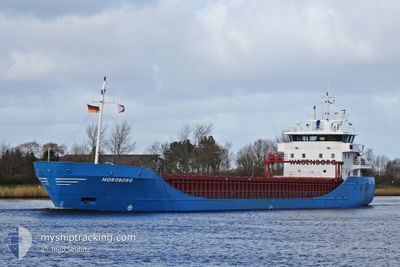
NORDBORG
General Cargo
Current Trip
| Time Travelled | 2 days |
|---|---|
| Remaining Time | --- |
| Distance Travelled | 687.90 nm |
| Remaining Distance | --- |
| AVG Speed | 11.6 Noeuds |
| MAX Speed | 14.8 Noeuds |
| AVG Wind | 27.9 knots |
| MAX Wind | 40.4 knots |
| MIN Temp | 2.8°C / 37.04°F |
| MAX Temp | 13.8°C / 56.84°F |
| Tirant d eau | 6.1 m |
| Position reçue | 4 h, 40 m depuis |
Current Position
| Longitude | --- |
|---|---|
| Latitude | --- |
| Etat | Under way using engine |
| Vitesse | 10.3 Noeuds |
| Parcours | 43.1° |
| Zone | North Sea |
| Station | T-AIS |
| Position reçue | 4 h, 40 m depuis |
Info
Information
The current position of NORDBORG is in North Sea with coordinates 52.04509° / 2.98750° as reported on 2024-11-24 00:20 by AIS to our vessel tracker app. The vessel's current speed is 10.3 Noeuds and is heading at the port of HARGSHAMN. The estimated time of arrival as calculated by MyShipTracking vessel tracking app is 2024-11-28 03:30 LT
The vessel NORDBORG (IMO: 9148180, MMSI: 245157000) is a General Cargo that was built in 1999 ( 25 Age ). It's sailing under the flag of [NL] Netherlands.
In this page you can find informations about the vessels current position, last detected port calls, and current voyage information. If the vessels is not in coverage by AIS you will find the latest position.
The current position of NORDBORG is detected by our AIS receivers and we are not responsible for the reliability of the data. The last position was recorded while the vessel was in Coverage by the Ais receivers of our vessel tracking app.
The current draught of NORDBORG as reported by AIS is 6.1 meters
Weather
| Temperature | 13.2°C / 55.76°F |
|---|---|
| Wind Speed | 33 knots |
| Direction | 206° SSW |
| Pressure | 999.9 hPa |
| Humidity | 79.9 % |
| Cloud Coverage | 100 % |
Featured Company
Last Port Calls
| Port | Arrival | Departure | Time In Port |
|---|---|---|---|
| 2024-11-16 11:02 | 2024-11-21 11:10 | 5 d | |
| 2024-11-14 09:27 | 2024-11-15 20:51 | 1 d | |
| 2024-11-06 08:20 | 2024-11-07 18:36 | 1 d | |
| 2024-11-04 12:52 | 2024-11-05 19:24 | 1 d | |
| 2024-10-31 18:51 | 2024-10-31 20:25 | 1 h | |
| 2024-10-30 19:44 | 2024-10-31 18:09 | 22 h | |
| 2024-10-02 14:51 | 2024-10-25 15:22 | 23 d | |
| 2024-09-30 09:34 | 2024-10-01 20:47 | 1 d | |
| 2024-09-21 15:42 | 2024-09-24 07:24 | 2 d | |
| 2024-09-18 17:55 | 2024-09-20 10:39 | 1 d |
Last Trips
| Origin | Departure | Destination | Arrival | Distance | |
|---|---|---|---|---|---|
| 2024-11-15 20:51 | 2024-11-16 11:02 | 34.07 nm | |||
| 2024-11-07 20:36 | 2024-11-14 09:27 | 1391.30 nm | |||
| 2024-11-05 21:24 | 2024-11-06 10:20 | 70.68 nm | |||
| 2024-10-31 21:25 | 2024-11-04 14:52 | 777.83 nm | |||
| 2024-10-31 19:09 | 2024-10-31 19:51 | 2.17 nm | |||
| 2024-10-25 17:22 | 2024-10-30 20:44 | 190.29 nm | |||
| 2024-10-01 22:47 | 2024-10-02 16:51 | 192.93 nm | |||
| 2024-09-24 08:24 | 2024-09-30 11:34 | 1231.30 nm | |||
| 2024-09-20 12:39 | 2024-09-21 16:42 | 288.32 nm | |||
| 2024-09-11 11:33 | 2024-09-18 19:55 | 1710.79 nm |
Events
| Heure | Evenement | Détails | Position/ Destination | Info |
|---|---|---|---|---|
| 2024-11-24 00:24 | Etat Changé | Default Under way using engine |
52.05434 / 3.00151
HARGSHAMN SWEDEN
|
Vitesse: 10.3 kn Parcours: 43.1° |
| 2024-11-24 00:20 | Hors de la zone couverte |
52.04509 / 2.98750
North Sea
HARGSHAMN SWEDEN
|
Vitesse: 10.3 kn Parcours: 43.1° |
|
| 2024-11-23 22:32 | Changement de zone | Dutch part of the North Sea Belgian part of the North Sea |
51.80714 / 2.65502
North Sea
HARGSHAMN SWEDEN
|
Vitesse: 10.8 kn Parcours: 44.6° |
| 2024-11-23 20:35 | Changement de zone | Belgian part of the North Sea French part of the North Sea |
51.52542 / 2.26889
North Sea
HARGSHAMN SWEDEN
|
Vitesse: 11.8 kn Parcours: 41.2° |
| 2024-11-23 20:29 | Etat Changé | Under way using engine Default |
51.51118 / 2.24837
HARGSHAMN SWEDEN
|
Vitesse: 11.8 kn Parcours: 39° |
| 2024-11-23 20:20 | Etat Changé | Default Under way using engine |
51.48982 / 2.21956
HARGSHAMN SWEDEN
|
Vitesse: 12.1 kn Parcours: 36.2° |
| 2024-11-23 20:16 | Changement de zone | French part of the North Sea United Kingdom part of the North Sea |
51.47867 / 2.20639
North Sea
HARGSHAMN SWEDEN
|
Vitesse: 12.1 kn Parcours: 36.2° |
| 2024-11-23 20:16 | Etat Changé | Under way using engine Default |
51.47867 / 2.20639
HARGSHAMN SWEDEN
|
Vitesse: 12.4 kn Parcours: 37° |
| 2024-11-23 19:24 | Etat Changé | Default Under way using engine |
51.35533 / 2.02194
HARGSHAMN SWEDEN
|
Vitesse: 12.5 kn Parcours: 42.7° |
| 2024-11-23 17:50 | Changement de zone | United Kingdom part of the North Sea French part of the North Sea |
51.08461 / 1.66972
North Sea
HARGSHAMN SWEDEN
|
Vitesse: 14.2 kn Parcours: 36° |