
NG RESOLUTION
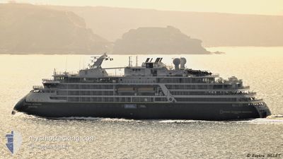
Passenger
Current Trip
TORELLNESET
| Time Travelled | 7 days |
|---|---|
| Remaining Time | --- |
| Distance Travelled | 1962.94 nm |
| Remaining Distance | --- |
| AVG Speed | 12.3 Noeuds |
| MAX Speed | 17.1 Noeuds |
| AVG Wind | 16.3 knots |
| MAX Wind | 29.9 knots |
| MIN Temp | -12.1°C / 10.22°F |
| MAX Temp | 12°C / 53.6°F |
| Tirant d eau | 5.6 m |
| Position reçue | 1 m depuis |
Current Position
| Longitude | 19.79398° |
|---|---|
| Latitude | 79.49666° |
| Etat | Under way using engine |
| Vitesse | 16 Noeuds |
| Parcours | 137.7° |
| Zone | Barentsz Sea |
| Station | T-AIS |
| Position reçue | 1 m depuis |
Info
Information
The current position of NG RESOLUTION is in Barentsz Sea with coordinates 79.49666° / 19.79398° as reported on 2024-05-05 12:38 by AIS to our vessel tracker app. The vessel's current speed is 16 Noeuds
The vessel NG RESOLUTION (IMO: 9880685, MMSI: 311000893) is a Passenger It's sailing under the flag of [BS] Bahamas.
In this page you can find informations about the vessels current position, last detected port calls, and current voyage information. If the vessels is not in coverage by AIS you will find the latest position.
The current position of NG RESOLUTION is detected by our AIS receivers and we are not responsible for the reliability of the data. The last position was recorded while the vessel was in Coverage by the Ais receivers of our vessel tracking app.
The current draught of NG RESOLUTION as reported by AIS is 5.6 meters
Weather
| Temperature | -6.4°C / 20.48°F |
|---|---|
| Wind Speed | 7 knots |
| Direction | 344° NNW |
| Pressure | 1025.8 hPa |
| Humidity | 79.1 % |
| Cloud Coverage | 27 % |
Featured Company
Last Port Calls
| Port | Arrival | Departure | Time In Port |
|---|---|---|---|
| 2024-04-14 05:10 | 2024-04-28 07:17 | 14 d | |
| 2024-04-07 05:52 | 2024-04-07 12:17 | 6 h | |
| 2024-03-15 06:51 | 2024-03-15 07:54 | 1 h | |
| 2024-03-12 00:09 | 2024-03-12 22:05 | 21 h |
Last Trips
| Origin | Departure | Destination | Arrival | Distance | |
|---|---|---|---|---|---|
| 2024-04-07 13:17 | 2024-04-14 07:10 | 2343.35 nm | |||
| 2024-03-15 04:54 | 2024-04-07 06:52 | 6512.28 nm | |||
| 2024-03-12 19:05 | 2024-03-15 03:51 | 358.20 nm | |||
| 2024-02-21 17:12 | 2024-03-11 21:09 | 3752.32 nm |
Events
| Heure | Evenement | Détails | Position/ Destination | Info |
|---|---|---|---|---|
| 2024-05-05 11:34 | Démarrage |
79.43343 / 18.90852
TORELLNESET
|
Vitesse: 6.7 kn Parcours: 42.5° |
|
| 2024-05-05 11:02 | Changement de destination | TORELLNESET ALKEFJELLET |
79.43263 / 18.89318
TORELLNESET
|
Vitesse: 0.1 kn Parcours: 165° |
| 2024-05-05 11:02 | Changement d'ETA | 2024/05/05 14:00 2024/05/05 06:00 |
79.43263 / 18.89318
TORELLNESET
|
Vitesse: 0.1 kn Parcours: 165° |
| 2024-05-05 10:46 | Arret |
79.43186 / 18.89237
ALKEFJELLET
|
Vitesse: Parcours: 181° |
|
| 2024-05-05 10:32 | Démarrage |
79.43684 / 18.90058
ALKEFJELLET
|
Vitesse: 3.1 kn Parcours: 216° |
|
| 2024-05-05 10:01 | Arret |
79.44632 / 18.96491
ALKEFJELLET
|
Vitesse: 0.3 kn Parcours: 185° |
|
| 2024-05-05 08:56 | Démarrage |
79.58922 / 18.51992
ALKEFJELLET
|
Vitesse: 5.9 kn Parcours: 136.1° |
|
| 2024-05-05 08:25 | Arret |
79.59103 / 18.50724
ALKEFJELLET
|
Vitesse: Parcours: 200° |
|
| 2024-05-05 07:25 | Démarrage |
79.67084 / 17.99413
ALKEFJELLET
|
Vitesse: 4 kn Parcours: 166° |
|
| 2024-05-05 06:22 | Arret |
79.67166 / 18.01155
ALKEFJELLET
|
Vitesse: 0.2 kn Parcours: 359° |