
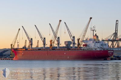
NEW ISLAND
Bulk Carrier
Current Trip
| Time Travelled | 5 days |
|---|---|
| Remaining Time | --- |
| Distance Travelled | 1372.04 nm |
| Remaining Distance | --- |
| AVG Speed | 10.1 Noeuds |
| MAX Speed | 15 Noeuds |
| AVG Wind | 9.2 knots |
| MAX Wind | 24.4 knots |
| MIN Temp | 10°C / 50°F |
| MAX Temp | 19.6°C / 67.28°F |
| Tirant d eau | 5.9 m |
| Position reçue | 16 m depuis |
Current Position
| Longitude | 41.69213° |
|---|---|
| Latitude | 41.71856° |
| Etat | At anchor |
| Vitesse | 0.4 Noeuds |
| Parcours | 230° |
| Zone | Black Sea |
| Station | T-AIS |
| Position reçue | 16 m depuis |
Info
Information
The current position of NEW ISLAND is in Black Sea with coordinates 41.71856° / 41.69213° as reported on 2024-05-05 21:25 by AIS to our vessel tracker app. The vessel's current speed is 0.4 Noeuds
The vessel NEW ISLAND (IMO: 9258349, MMSI: 249860000) is a Bulk Carrier that was built in 2002 ( 22 Age ). It's sailing under the flag of [MT] Malta.
In this page you can find informations about the vessels current position, last detected port calls, and current voyage information. If the vessels is not in coverage by AIS you will find the latest position.
The current position of NEW ISLAND is detected by our AIS receivers and we are not responsible for the reliability of the data. The last position was recorded while the vessel was in Coverage by the Ais receivers of our vessel tracking app.
The current draught of NEW ISLAND as reported by AIS is 5.9 meters
Weather
| Temperature | 10°C / 50°F |
|---|---|
| Wind Speed | 8 knots |
| Direction | 185° S |
| Pressure | 1014.6 hPa |
| Humidity | 82.4 % |
| Cloud Coverage | 97 % |
Featured Company
Last Port Calls
| Port | Arrival | Departure | Time In Port |
|---|---|---|---|
| 2024-04-20 22:41 | 2024-04-30 09:48 | 9 d | |
| 2024-04-20 10:20 | 2024-04-20 21:54 | 11 h | |
| 2024-04-03 01:51 | 2024-04-03 03:07 | 1 h | |
| 2024-03-22 10:04 | 2024-03-27 15:23 | 5 d | |
| 2024-03-07 12:25 | 2024-03-15 18:09 | 8 d |
Most Visited Ports (Last year)
| Port | Arrivals | |
|---|---|---|
| 4 | ||
| 3 | ||
| 2 | ||
| 2 | ||
| 1 | ||
| 1 |
Last Trips
| Origin | Departure | Destination | Arrival | Distance | |
|---|---|---|---|---|---|
| 2024-04-20 23:54 | 2024-04-21 00:41 | 3.93 nm | |||
| 2024-04-03 06:07 | 2024-04-20 12:20 | 1720.87 nm | |||
| 2024-03-27 18:23 | 2024-04-03 04:51 | 656.19 nm | |||
| 2024-03-15 20:09 | 2024-03-22 13:04 | 538.48 nm |
Events
| Heure | Evenement | Détails | Position/ Destination | Info |
|---|---|---|---|---|
| 2024-05-05 21:31 | Etat Changé | Default At anchor |
41.71870 / 41.69192
GE BUS
|
Vitesse: 0.4 kn Parcours: 230° |
| 2024-05-05 21:25 | Etat Changé | At anchor Default |
41.71856 / 41.69213
GE BUS
|
Vitesse: 0.2 kn Parcours: 225° |
| 2024-05-05 20:52 | Etat Changé | Default At anchor |
41.71877 / 41.69198
GE BUS
|
Vitesse: 0.3 kn Parcours: 229° |
| 2024-05-05 20:49 | Etat Changé | At anchor Default |
41.71856 / 41.69222
GE BUS
|
Vitesse: 0.5 kn Parcours: 231° |
| 2024-05-05 20:34 | Etat Changé | Default At anchor |
41.71854 / 41.69235
GE BUS
|
Vitesse: 0.4 kn Parcours: 222° |
| 2024-05-05 20:31 | Etat Changé | At anchor Default |
41.71846 / 41.69225
GE BUS
|
Vitesse: 0.4 kn Parcours: 235° |
| 2024-05-05 20:10 | Etat Changé | Default At anchor |
41.71869 / 41.69211
GE BUS
|
Vitesse: 0.1 kn Parcours: 232° |
| 2024-05-05 20:07 | Etat Changé | At anchor Default |
41.71851 / 41.69224
GE BUS
|
Vitesse: Parcours: 227° |
| 2024-05-05 19:52 | Etat Changé | Default At anchor |
41.71870 / 41.69209
GE BUS
|
Vitesse: 0.2 kn Parcours: 235° |
| 2024-05-05 19:49 | Etat Changé | At anchor Default |
41.71854 / 41.69229
GE BUS
|
Vitesse: 0.1 kn Parcours: 227° |