
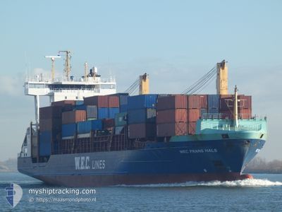
WEC FRANS HALS
Container Ship
Current Trip
| Time Travelled | 11 h, 36 mins |
|---|---|
| Remaining Time | 2 days |
| Distance Travelled | 168.70 nm |
| Remaining Distance | 771.46 nm |
| AVG Speed | 15 Noeuds |
| MAX Speed | 15.5 Noeuds |
| AVG Wind | 5.1 knots |
| MAX Wind | 9.9 knots |
| MIN Temp | 11.1°C / 51.98°F |
| MAX Temp | 13.5°C / 56.3°F |
| Tirant d eau | 6.8 m |
| Position reçue | 2 m depuis |
Current Position
| Longitude | -9.39946° |
|---|---|
| Latitude | 43.74081° |
| Etat | Under way using engine |
| Vitesse | 15.1 Noeuds |
| Parcours | 25.3° |
| Zone | North Atlantic Ocean |
| Station | T-AIS |
| Position reçue | 2 m depuis |
Info
Information
The current position of WEC FRANS HALS is in North Atlantic Ocean with coordinates 43.74081° / -9.39946° as reported on 2024-04-26 12:04 by AIS to our vessel tracker app. The vessel's current speed is 15.1 Noeuds and is heading at the port of ANTWERP. The estimated time of arrival as calculated by MyShipTracking vessel tracking app is 2024-04-28 15:17 LT
The vessel WEC FRANS HALS (IMO: 9326964, MMSI: 255806165) is a Container Ship that was built in 2005 ( 19 Age ). It's sailing under the flag of [PT] Portugal.
In this page you can find informations about the vessels current position, last detected port calls, and current voyage information. If the vessels is not in coverage by AIS you will find the latest position.
The current position of WEC FRANS HALS is detected by our AIS receivers and we are not responsible for the reliability of the data. The last position was recorded while the vessel was in Coverage by the Ais receivers of our vessel tracking app.
The current draught of WEC FRANS HALS as reported by AIS is 6.8 meters
Weather
| Temperature | 11°C / 51.8°F |
|---|---|
| Wind Speed | 10 knots |
| Direction | 87° E |
| Pressure | 1003.2 hPa |
| Humidity | 81.6 % |
| Cloud Coverage | 100 % |
Featured Company
Last Port Calls
| Port | Arrival | Departure | Time In Port |
|---|---|---|---|
| 2024-04-25 06:02 | 2024-04-26 00:31 | 18 h | |
| 2024-04-21 19:03 | 2024-04-22 14:01 | 18 h | |
| 2024-04-20 22:13 | 2024-04-21 02:27 | 4 h | |
| 2024-04-20 20:28 | 2024-04-20 20:37 | 9 m | |
| 2024-04-19 10:28 | |||
| 2024-04-18 11:33 | 2024-04-18 19:28 | 7 h | |
| 2024-04-16 10:45 | 2024-04-16 18:18 | 7 h | |
| 2024-04-15 04:06 | 2024-04-15 16:12 | 12 h | |
| 2024-04-13 16:31 | 2024-04-13 23:04 | 6 h | |
| 2024-04-11 13:00 | 2024-04-13 00:31 | 1 d |
Most Visited Ports (Last year)
| Port | Arrivals | |
|---|---|---|
| 35 | ||
| 25 | ||
| 25 | ||
| 23 | ||
| 16 | ||
| 15 |
Last Trips
| Origin | Departure | Destination | Arrival | Distance | |
|---|---|---|---|---|---|
| 2024-04-22 16:01 | 2024-04-25 07:02 | 969.99 nm | |||
| 2024-04-21 04:27 | 2024-04-21 21:03 | 113.76 nm | |||
| 2024-04-20 22:37 | 2024-04-21 00:13 | 15.99 nm | |||
| 2024-04-18 20:28 | 2024-04-20 22:28 | 158.83 nm | |||
| 2024-04-18 20:28 | 2024-04-19 12:28 | 158.45 nm | |||
| 2024-04-16 20:18 | 2024-04-18 12:33 | 587.38 nm | |||
| 2024-04-15 18:12 | 2024-04-16 12:45 | 246.40 nm | |||
| 2024-04-14 01:04 | 2024-04-15 06:06 | 401.93 nm | |||
| 2024-04-13 01:31 | 2024-04-13 18:31 | 79.64 nm | |||
| 2024-04-10 07:35 | 2024-04-11 14:00 | 476.88 nm |
Events
| Heure | Evenement | Détails | Position/ Destination | Info |
|---|---|---|---|---|
| 2024-04-26 11:32 | Changement d'ETA | 2024/04/28 15:00 2024/04/28 20:00 |
43.62167 / -9.47895
BEANR
|
Vitesse: 14.6 kn Parcours: 27° |
| 2024-04-26 11:01 | Etat Changé | Under way using engine Default |
43.50767 / -9.55833
BEANR
|
Vitesse: 15.4 kn Parcours: 25° |
| 2024-04-26 10:50 | Etat Changé | Default Under way using engine |
43.46691 / -9.58592
BEANR
|
Vitesse: 15.2 kn Parcours: 27.1° |
| 2024-04-26 10:18 | Changement de zone | Spanish part of the North Atlantic Ocean Portuguese part of the North Atlantic Ocean |
43.34453 / -9.66973
North Atlantic Ocean
BEANR
|
Vitesse: 15.3 kn Parcours: 28.5° |
| 2024-04-26 10:17 | Dans la zone couverte |
43.34453 / -9.66973
North Atlantic Ocean
BEANR
|
Vitesse: 15.3 kn Parcours: 28.5° |
|
| 2024-04-26 01:57 | Etat Changé | Default Under way using engine |
41.41184 / -9.00726
BEANR
|
Vitesse: 15.2 kn Parcours: 319.7° |
| 2024-04-26 01:49 | Etat Changé | Under way using engine Default |
41.38534 / -8.97822
BEANR
|
Vitesse: 15.1 kn Parcours: 320° |
| 2024-04-26 01:49 | Hors de la zone couverte |
41.38534 / -8.97822
North Atlantic Ocean
BEANR
|
Vitesse: 15.2 kn Parcours: 319.7° |
|
| 2024-04-26 01:43 | Etat Changé | Default Under way using engine |
41.36800 / -8.95883
BEANR
|
Vitesse: 15 kn Parcours: 319° |
| 2024-04-26 00:40 | Changement d'ETA | 2024/04/28 20:00 2024/04/29 14:00 |
41.16973 / -8.72571
BEANR
|
Vitesse: 13.5 kn Parcours: 315° |