
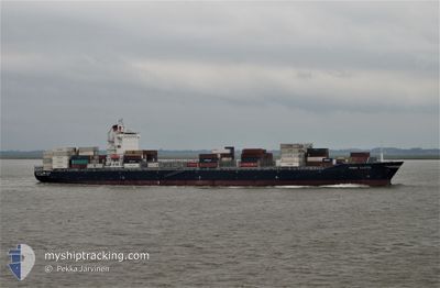
NAVIOS TEMPO
Container Ship
Current Trip
| Time Travelled | 3 days |
|---|---|
| Remaining Time | 3 days |
| Distance Travelled | 1179.74 nm |
| Remaining Distance | 1820.60 nm |
| AVG Speed | 13.4 Noeuds |
| MAX Speed | 18.2 Noeuds |
| AVG Wind | 11.3 knots |
| MAX Wind | 18.3 knots |
| MIN Temp | 23.2°C / 73.76°F |
| MAX Temp | 26.6°C / 79.88°F |
| Tirant d eau | 10.6 m |
| Position reçue | 3 d depuis |
Current Position
| Longitude | --- |
|---|---|
| Latitude | --- |
| Etat | Under way using engine |
| Vitesse | 13.6 Noeuds |
| Parcours | 85° |
| Zone | Singapore Strait |
| Station | T-AIS |
| Position reçue | 3 d depuis |
Info
Information
The current position of NAVIOS TEMPO is in Singapore Strait with coordinates 1.25713° / 104.17127° as reported on 2025-02-14 01:31 by AIS to our vessel tracker app. The vessel's current speed is 13.6 Noeuds and is heading at the port of TIANJIN. The estimated time of arrival as calculated by MyShipTracking vessel tracking app is 2025-02-20 21:42 LT
The vessel NAVIOS TEMPO (IMO: 9404209, MMSI: 636018311) is a Container Ship that was built in 2010 ( 15 Age ). It's sailing under the flag of [LR] Liberia.
In this page you can find informations about the vessels current position, last detected port calls, and current voyage information. If the vessels is not in coverage by AIS you will find the latest position.
The current position of NAVIOS TEMPO is detected by our AIS receivers and we are not responsible for the reliability of the data. The last position was recorded while the vessel was in Coverage by the Ais receivers of our vessel tracking app.
The current draught of NAVIOS TEMPO as reported by AIS is 10.6 meters
Weather
| Temperature | 23.3°C / 73.94°F |
|---|---|
| Wind Speed | 20 knots |
| Direction | 60° ENE |
| Pressure | 1018.5 hPa |
| Humidity | 80.4 % |
| Cloud Coverage | 89 % |
Featured Company
Last Port Calls
| Port | Arrival | Departure | Time In Port |
|---|---|---|---|
| 2025-02-12 14:41 | 2025-02-13 19:58 | 1 d | |
| 2025-02-09 15:53 | 2025-02-10 16:50 | 1 d | |
| 2025-01-31 08:41 | 2025-02-01 13:28 | 1 d | |
| 2025-01-22 00:37 | 2025-01-23 02:33 | 1 d | |
| 2025-01-16 11:05 | 2025-01-16 21:56 | 10 h | |
| 2024-12-10 01:52 | 2025-01-11 08:09 | ||
| 2024-12-07 14:52 | 2024-12-08 04:21 | 13 h |
Most Visited Ports (Last year)
| Port | Arrivals | |
|---|---|---|
| 24 | ||
| 14 | ||
| 11 | ||
| 3 | ||
| 3 | ||
| 2 |
Last Trips
| Origin | Departure | Destination | Arrival | Distance | |
|---|---|---|---|---|---|
| 2025-02-11 00:50 | 2025-02-12 22:41 | 279.91 nm | |||
| 2025-02-01 21:28 | 2025-02-09 23:53 | 2825.42 nm | |||
| 2025-01-23 10:33 | 2025-01-31 16:41 | 2866.91 nm | |||
| 2025-01-17 05:56 | 2025-01-22 08:37 | 2178.49 nm | |||
| 2025-01-11 16:09 | 2025-01-16 19:05 | 554.09 nm | |||
| 2024-12-08 12:21 | 2024-12-10 09:52 | 588.10 nm | |||
| 2024-11-25 20:38 | 2024-12-07 22:52 | 4678.60 nm |
Events
| Heure | Evenement | Détails | Position/ Destination | Info |
|---|---|---|---|---|
| 2025-02-14 01:41 | Etat Changé | Default Under way using engine |
1.26088 / 104.21194
CNTXG
|
Vitesse: 13.6 kn Parcours: 85° |
| 2025-02-14 01:31 | Changement de zone | Malaysian part of the Singapore Strait Indonesian part of the Singapore Strait |
1.25713 / 104.17127
Singapore Strait
CNTXG
|
Vitesse: 13.6 kn Parcours: 85° |
| 2025-02-14 01:31 | Hors de la zone couverte |
1.25713 / 104.17127
Singapore Strait
CNTXG
|
Vitesse: 13.6 kn Parcours: 85° |
|
| 2025-02-14 00:01 | Etat Changé | Under way using engine Moored |
1.20385 / 103.89424
CNTXG
|
Vitesse: 10 kn Parcours: 74.3° |
| 2025-02-13 21:34 | Changement de zone | Indonesian part of the Singapore Strait Malaysian part of the Singapore Strait |
1.11211 / 103.54838
Singapore Strait
CNTXG
|
Vitesse: 9.3 kn Parcours: 123.8° |
| 2025-02-13 21:34 | Etat Changé | Moored Default |
1.11211 / 103.54838
CNTXG
|
Vitesse: 9.2 kn Parcours: 135° |
| 2025-02-13 21:09 | Etat Changé | Default Moored |
1.17937 / 103.57865
CNTXG
|
Vitesse: 9.6 kn Parcours: 205.4° |
| 2025-02-13 20:55 | Changement de zone | Malaysian part of the Singapore Strait Indonesian part of the Singapore Strait |
1.20432 / 103.59626
Singapore Strait
CNTXG
|
Vitesse: 4.7 kn Parcours: 271.2° |
| 2025-02-13 20:29 | Changement de zone | Indonesian part of the Singapore Strait Singaporean part of the Singapore Strait |
1.19309 / 103.64562
Singapore Strait
CNTXG
|
Vitesse: 7.1 kn Parcours: 276.1° |
| 2025-02-13 19:58 | PORT DE DEPART |
|
1.25581 / 103.64562
CNTXG
|
Vitesse: 6.6 kn Parcours: 99° |