
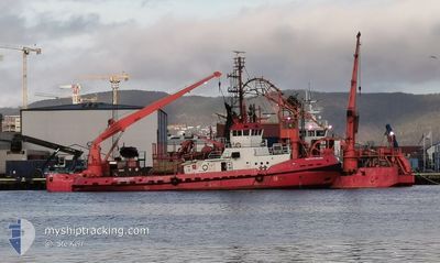
NAUTILUS BALDER
Tug
Current Trip
| Time Travelled | 17 days |
|---|---|
| Remaining Time | --- |
| Distance Travelled | 704.75 nm |
| Remaining Distance | --- |
| AVG Speed | 8.4 Noeuds |
| MAX Speed | 14.5 Noeuds |
| AVG Wind | 8.7 knots |
| MAX Wind | 23.8 knots |
| MIN Temp | 7.8°C / 46.04°F |
| MAX Temp | 18.3°C / 64.94°F |
| Tirant d eau | 5.5 m |
| Position reçue | 2 m depuis |
Current Position
| Longitude | 13.17630° |
|---|---|
| Latitude | 66.27362° |
| Etat | Moored |
| Vitesse | |
| Parcours | 234° |
| Zone | Norwegian Sea |
| Station | T-AIS |
| Position reçue | 2 m depuis |
Info
Information
The current position of NAUTILUS BALDER is in Norwegian Sea with coordinates 66.27362° / 13.17630° as reported on 2024-09-08 00:40 by AIS to our vessel tracker app. The vessel's current speed is 0 Noeuds
The vessel NAUTILUS BALDER (IMO: 8406157, MMSI: 258283000) is a Tug that was built in 1985 ( 39 Age ). It's sailing under the flag of [NO] Norway.
In this page you can find informations about the vessels current position, last detected port calls, and current voyage information. If the vessels is not in coverage by AIS you will find the latest position.
The current position of NAUTILUS BALDER is detected by our AIS receivers and we are not responsible for the reliability of the data. The last position was recorded while the vessel was in Coverage by the Ais receivers of our vessel tracking app.
The current draught of NAUTILUS BALDER as reported by AIS is 5.5 meters
Weather
| Temperature | 13.2°C / 55.76°F |
|---|---|
| Wind Speed | 9 knots |
| Direction | 91° E |
| Pressure | 1017.4 hPa |
| Humidity | 85 % |
| Cloud Coverage | 24 % |
Featured Company
Last Port Calls
| Port | Arrival | Departure | Time In Port |
|---|---|---|---|
| 2024-08-20 22:50 | 2024-08-21 19:00 | 20 h | |
| 2024-08-16 08:53 | 2024-08-20 07:16 | 3 d | |
| 2024-08-12 19:32 | 2024-08-15 13:39 | 2 d | |
| 2024-07-31 02:41 | 2024-08-02 16:38 | 2 d | |
| 2024-07-26 09:13 | 2024-07-26 09:33 | 19 m | |
| 2024-07-24 11:06 | 2024-07-25 09:16 | 22 h | |
| 2024-07-24 10:26 | 2024-07-24 10:48 | 22 m | |
| 2024-07-23 16:49 | 2024-07-24 09:53 | 17 h | |
| 2024-07-23 16:03 | 2024-07-23 16:23 | 19 m | |
| 2024-07-21 19:41 | 2024-07-23 15:35 | 1 d |
Most Visited Ports (Last year)
| Port | Arrivals | |
|---|---|---|
| 14 | ||
| 7 | ||
| 5 | ||
| 4 | ||
| 4 | ||
| 3 |
Last Trips
| Origin | Departure | Destination | Arrival | Distance | |
|---|---|---|---|---|---|
| 2024-08-20 07:16 | 2024-08-20 22:50 | 126.73 nm | |||
| 2024-08-15 13:39 | 2024-08-16 08:53 | 158.58 nm | |||
| 2024-08-02 16:38 | 2024-08-12 19:32 | 110.13 nm | |||
| 2024-07-26 09:33 | 2024-07-31 02:41 | 78.58 nm | |||
| 2024-07-25 09:16 | 2024-07-26 09:13 | 173.85 nm | |||
| 2024-07-24 10:48 | 2024-07-24 11:06 | 2.91 nm | |||
| 2024-07-24 09:53 | 2024-07-24 10:26 | 3.17 nm | |||
| 2024-07-23 16:23 | 2024-07-23 16:49 | 2.94 nm | |||
| 2024-07-23 15:35 | 2024-07-23 16:03 | 3.39 nm | |||
| 2024-07-20 21:52 | 2024-07-21 19:41 | 172.81 nm |
Events
| Heure | Evenement | Détails | Position/ Destination | Info |
|---|---|---|---|---|
| 2024-09-07 22:08 | Etat Changé | Moored Towing Astern |
66.27356 / 13.17640
NESNA
|
Vitesse: Parcours: 234° |
| 2024-09-07 22:00 | Arret | 5.81 nm, South East of STOKKVOGEN |
66.27360 / 13.17632
NESNA
|
Vitesse: Parcours: 235° |
| 2024-09-07 19:12 | Etat Changé | Towing Astern Under way using engine |
66.47022 / 12.88761
NESNA
|
Vitesse: 7.8 kn Parcours: 90.1° |
| 2024-09-07 17:51 | Démarrage | 8.96 nm, West of SELSOYA |
66.53641 / 12.62422
NESNA
|
Vitesse: 3.1 kn Parcours: 117° |
| 2024-09-07 17:27 | Changement de destination | NESNA NOSOY |
66.53895 / 12.61542
NESNA
|
Vitesse: 0.9 kn Parcours: 189° |
| 2024-09-07 17:26 | Etat Changé | Under way using engine Pushing Ahead - Towing |
66.53872 / 12.61516
NOSOY
|
Vitesse: 0.9 kn Parcours: 186° |
| 2024-09-07 13:51 | Etat Changé | Pushing Ahead - Towing Moored |
66.53845 / 12.61347
NOSOY
|
Vitesse: Parcours: 175° |
| 2024-09-07 00:55 | Etat Changé | Moored Restricted manoeuverability |
66.53846 / 12.61459
NOSOY
|
Vitesse: Parcours: 169° |
| 2024-09-06 22:34 | Etat Changé | Restricted manoeuverability Towing Astern |
66.53842 / 12.61595
NOSOY
|
Vitesse: 0.2 kn Parcours: 339° |
| 2024-09-06 22:26 | Arret | 9.14 nm, West of SELSOYA |
66.53808 / 12.61501
NOSOY
|
Vitesse: 0.2 kn Parcours: 292° |