
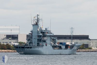
NATO WARSHIP A516
Military ops
Current Trip
Unknown
| Time Travelled | 6 days |
|---|---|
| Remaining Time | --- |
| Distance Travelled | 820.98 nm |
| Remaining Distance | --- |
| AVG Speed | 9.7 Noeuds |
| MAX Speed | 14.3 Noeuds |
| AVG Wind | 12.5 knots |
| MAX Wind | 27 knots |
| MIN Temp | 0.2°C / 32.36°F |
| MAX Temp | 13.1°C / 55.58°F |
| Tirant d eau | 3.9 m |
| Position reçue | Maintenant |
Current Position
| Longitude | 10.74984° |
|---|---|
| Latitude | 54.58481° |
| Etat | Under way using engine |
| Vitesse | 7.7 Noeuds |
| Parcours | 266.5° |
| Zone | Baltic Sea |
| Station | T-AIS |
| Position reçue | Maintenant |
Info
Information
The current position of NATO WARSHIP A516 is in Baltic Sea with coordinates 54.58481° / 10.74984° as reported on 2024-04-29 00:19 by AIS to our vessel tracker app. The vessel's current speed is 7.7 Noeuds
The vessel NATO WARSHIP A516 (MMSI: 211211520) is a Military ops It's sailing under the flag of [DE] Germany.
In this page you can find informations about the vessels current position, last detected port calls, and current voyage information. If the vessels is not in coverage by AIS you will find the latest position.
The current position of NATO WARSHIP A516 is detected by our AIS receivers and we are not responsible for the reliability of the data. The last position was recorded while the vessel was in Coverage by the Ais receivers of our vessel tracking app.
The current draught of NATO WARSHIP A516 as reported by AIS is 3.9 meters
Weather
| Temperature | 9.4°C / 48.92°F |
|---|---|
| Wind Speed | 8 knots |
| Direction | 255° WSW |
| Pressure | 1016.9 hPa |
| Humidity | 87.3 % |
| Cloud Coverage | 86 % |
Featured Company
Last Port Calls
| Port | Arrival | Departure | Time In Port |
|---|---|---|---|
| 2024-04-19 06:07 | 2024-04-22 06:09 | 3 d | |
| 2024-04-12 06:17 | 2024-04-15 05:33 | 2 d | |
| 2024-04-05 07:23 | 2024-04-08 08:03 | 3 d | |
| 2024-03-29 08:10 | 2024-04-02 09:02 | 4 d | |
| 2024-03-28 05:36 | 2024-03-28 15:57 | 10 h | |
| 2024-03-27 15:39 | 2024-03-28 05:17 | 13 h | |
| 2024-03-22 07:34 | 2024-03-25 09:11 | 3 d | |
| 2024-03-15 07:33 | 2024-03-18 10:46 | 3 d | |
| 2024-03-02 07:33 | 2024-03-13 14:28 | 11 d | |
| 2024-02-25 07:50 | 2024-02-27 09:11 | 2 d |
Most Visited Ports (Last year)
| Port | Arrivals | |
|---|---|---|
| 21 | ||
| 5 | ||
| 2 | ||
| 2 | ||
| 1 | ||
| 1 |
Last Trips
| Origin | Departure | Destination | Arrival | Distance | |
|---|---|---|---|---|---|
| 2024-04-15 08:33 | 2024-04-19 09:07 | 315.98 nm | |||
| 2024-04-08 10:03 | 2024-04-12 09:17 | 332.22 nm | |||
| 2024-04-02 11:02 | 2024-04-05 09:23 | 458.65 nm | |||
| 2024-03-28 16:57 | 2024-03-29 09:10 | 207.14 nm | |||
| 2024-03-28 06:17 | 2024-03-28 06:36 | 0.51 nm | |||
| 2024-03-25 10:11 | 2024-03-27 16:39 | 565.96 nm | |||
| 2024-03-18 11:46 | 2024-03-22 08:34 | 733.42 nm | |||
| 2024-03-13 15:28 | 2024-03-15 08:33 | 364.20 nm | |||
| 2024-02-27 10:11 | 2024-03-02 08:33 | 782.58 nm | |||
| 2024-02-19 00:58 | 2024-02-25 08:50 | 1400.02 nm |
Events
| Heure | Evenement | Détails | Position/ Destination | Info |
|---|---|---|---|---|
| 2024-04-29 00:05 | Detecté en mer | Danish part of the Baltic Sea |
54.58683 / 10.80446
Baltic Sea
|
Vitesse: 8.2 kn Parcours: 265.8° |
| 2024-04-28 22:26 | Changement de zone | German part of the Baltic Sea Danish part of the Baltic Sea |
54.59245 / 11.24007
Baltic Sea
|
Vitesse: 10 kn Parcours: 285.7° |
| 2024-04-28 16:01 | Changement de zone | Danish part of the Baltic Sea Estonian part of the Gulf of Finland |
54.78631 / 12.68359
Baltic Sea
|
Vitesse: 10.8 kn Parcours: 240.6° |
| 2024-04-28 15:59 | Dans la zone couverte |
54.78631 / 12.68359
Baltic Sea
|
Vitesse: 10.8 kn Parcours: 240.6° |
|
| 2024-04-26 14:39 | Hors de la zone couverte |
59.56909 / 24.03064
Gulf of Finland
|
Vitesse: 11.4 kn Parcours: 247.4° |
|
| 2024-04-26 09:58 | Dans la zone couverte |
59.75498 / 25.57907
Gulf of Finland
|
Vitesse: 12.8 kn Parcours: 268.3° |
|
| 2024-04-26 08:29 | Hors de la zone couverte |
59.72556 / 26.20059
Gulf of Finland
|
Vitesse: 12.8 kn Parcours: 271.8° |
|
| 2024-04-26 05:50 | Dans la zone couverte |
59.52131 / 27.22668
Gulf of Finland
|
Vitesse: 11.6 kn Parcours: 284.9° |
|
| 2024-04-25 15:17 | Hors de la zone couverte |
59.47866 / 27.74561
Gulf of Finland
|
Vitesse: 11.1 kn Parcours: 274.7° |
|
| 2024-04-25 10:48 | Dans la zone couverte |
59.44494 / 27.54187
Gulf of Finland
|
Vitesse: 4.4 kn Parcours: 106° |