
NAGUAL
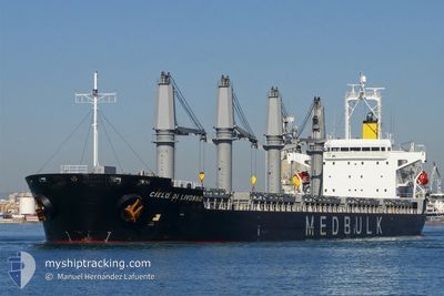
Bulk Carrier
Current Trip
| Trip Time | 26 days |
|---|---|
| Trip Distance | 6571.64 nm |
| AVG Speed | 10.7 Noeuds |
| MAX Speed | 10.7 Noeuds |
| Tirant d eau | 9.5 m |
| AVG Wind | 9.5 knots |
| MAX Wind | 23 knots |
| MIN Temp | 8°C / 46.4°F |
| MAX Temp | 30.2°C / 86.36°F |
| Position reçue | 3 m depuis |
Current Position
| Longitude | --- |
|---|---|
| Latitude | --- |
| Etat | Moored |
| Vitesse | |
| Parcours | 61° |
| Zone | Sea of Marmara |
| Station | T-AIS |
| Position reçue | 3 m depuis |
Info
Information
The current position of NAGUAL is in Sea of Marmara with coordinates 40.77727° / 29.60110° as reported on 2025-12-06 05:34 by AIS to our vessel tracker app. The vessel's current speed is 0 Noeuds and is currently inside the port of HEREKE.
The vessel NAGUAL (IMO: 9380829, MMSI: 538007314) is a Bulk Carrier that was built in 2008 ( 17 Age ). It's sailing under the flag of [MH] Marshall Is.
In this page you can find informations about the vessels current position, last detected port calls, and current voyage information. If the vessels is not in coverage by AIS you will find the latest position.
The current position of NAGUAL is detected by our AIS receivers and we are not responsible for the reliability of the data. The last position was recorded while the vessel was in Coverage by the Ais receivers of our vessel tracking app.
The current draught of NAGUAL as reported by AIS is 9.5 meters
Weather
| Temperature | 13.6°C / 56.48°F |
|---|---|
| Wind Speed | 6 knots |
| Direction | 113° ESE |
| Pressure | 1009.3 hPa |
| Humidity | 67.5 % |
| Cloud Coverage | 62 % |
Featured Company
Last Port Calls
| Port | Arrival | Departure | Time In Port |
|---|---|---|---|
| 2025-12-03 16:24 | |||
| 2025-11-28 08:16 | 2025-11-28 17:18 | 9 h | |
| 2025-10-27 20:38 | 2025-11-07 14:31 | 10 d |
Events
| Heure | Evenement | Détails | Position/ Destination | Info |
|---|---|---|---|---|
| 2025-12-04 16:55 | Etat Changé | Moored Default |
40.77730 / 29.60108
[TR] HEREKE
|
Vitesse: Parcours: 61° |
| 2025-12-04 16:49 | Etat Changé | Default Moored |
40.77737 / 29.60108
[TR] HEREKE
|
Vitesse: Parcours: 61° |
| 2025-12-04 09:28 | Etat Changé | Moored Default |
40.77728 / 29.60108
[TR] HEREKE
|
Vitesse: Parcours: 61° |
| 2025-12-04 09:16 | Etat Changé | Default Moored |
40.77730 / 29.60105
[TR] HEREKE
|
Vitesse: Parcours: 61° |
| 2025-12-03 13:43 | Etat Changé | Moored Under way using engine |
40.77726 / 29.60108
[TR] HEREKE
|
Vitesse: Parcours: 61° |
| 2025-12-03 13:35 | Arret |
40.77719 / 29.60102
[TR] HEREKE
|
Vitesse: 0.2 kn Parcours: 63° |
|
| 2025-12-03 13:24 | Port d'arrivée |
|
40.77253 / 29.59574
[TR] HEREKE
|
Vitesse: 3.8 kn Parcours: 44° |
| 2025-12-03 09:45 | Démarrage | 1.29 nm, South East of ZEYTINBURNU |
40.97072 / 28.91903
TR HER
|
Vitesse: 3.1 kn Parcours: 193° |
| 2025-12-03 09:32 | Etat Changé | Under way using engine At anchor |
40.97180 / 28.92199
TR HER
|
Vitesse: Parcours: 235° |
| 2025-12-02 05:46 | Arret | 1.01 nm, South East of ZEYTINBURNU |
40.97133 / 28.91255
TR HER
|
Vitesse: 0.1 kn Parcours: 62° |